Situation Summary
Angola remains at moderate global security rank (#51, composite threat score 45) with no verified armed conflict, mass civil unrest, or major crime incidents reported in the last 24–48 hours. The dominant current threat is environmental rather than security-driven: active wildfire activity across multiple provinces is affecting logistics, transport corridors, and mining operations. Structural risks in resource-rich border provinces (Cabinda, Lunda Norte/Sul, Cuando Cubango) persist as chronic vulnerabilities, though immediate flashpoint activity is absent from open-source reporting.
Key Developments
- Luanda, 30 June 2026 – ACHOD 2026 (African Chiefs of Defense Conference) opening with delegations from over 35 African and partner nations. Heightened military and diplomatic presence expected throughout the capital; expect elevated security protocols at conference venues and major hotels, with potential traffic disruptions on key routes.
- Multiple provinces (rural areas), 29–30 June 2026 – At least 12 distinct wildfire events detected across Angola, affecting transport corridors and mining logistics. No specific casualties or infrastructure damage reported, but travel advisories and route diversions likely in affected regions.
- Nationwide, 29–30 June 2026 – No verified armed clashes, kidnappings, mass protests, or major security breaches detected in last 24–48 hours based on open-source and social media monitoring. Limited communications from remote areas means smaller incidents may remain unreported.
- Southern/southeastern border areas, ongoing context – Regional border-security focus (linked to broader southern African dynamics) underscores persistent vulnerabilities in Cunene and Cuando Cubango provinces, though no specific new cross-border incident is corroborated for the reporting period.
Highest-Risk Areas
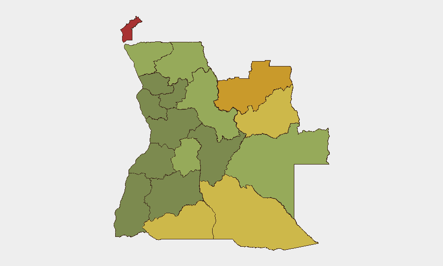
Cabinda Province (risk 78) and the two Lunda provinces (Norte, 72; Sul, 68) drive the country's sub-national threat profile, driven by historical resource-extraction conflict, limited state control, and transnational criminal networks. Cuando Cubango, Cunene, and Moxico provinces rank fifth through sixth due to remote border locations and weak governance capacity. Huambo and Uíge follow as secondary risk centers. The capital (Luanda) and central provinces (Bié, Huíla) show substantially lower composite risk scores, reflecting stronger state presence and urban infrastructure, though the ACHOD conference brings temporary concentration of high-level security assets.
How GeoBit Would Assist
Security and duty-of-care teams in Angola would benefit from AOI Monitoring & Early Warning on high-risk provinces (Cabinda, Lunda Norte/Sul, border crossing points) to detect emerging armed activity or civil unrest with minimal reporting lag. Routing & Network Analysis can identify real-time alternative logistics routes around active wildfires and assess safe travel corridors during the ACHOD conference period. Intel Sweep, OSINT fusion, and multi-language search across open web sources, X/Twitter, and local media would provide rapid corroboration of smaller-scale incidents in remote areas where mainstream reporting delays reporting by days.
7-Day Outlook
Wildfire activity is expected to remain the primary operational hazard over the next 7 days, with potential impact on mining and logistics schedules. ACHOD conference presence in Luanda will elevate security measures in the capital through early July, creating temporary traffic disruption but no increased conflict risk. No escalation of armed activity, civil unrest, or transnational crime is forecast for the immediate period based on current open-source indicators, though structural vulnerabilities in Cabinda and Lunda provinces warrant continuous monitoring.
Highest-Risk Areas — Ranked
| # | State / Region | Risk |
|---|---|---|
| 1 | Cabinda Province | 78 |
| 2 | Lunda Norte Province | 72 |
| 3 | Lunda Sul Province | 68 |
| 4 | Cuando Cubango Province | 64 |
| 5 | Cunene Province | 62 |
| 6 | Moxico Province | 58 |
| 7 | Zaire Province | 54 |
| 8 | Huambo Province | 50 |
| 9 | Uíge Province | 48 |
| 10 | Malanje Province | 42 |
| 11 | Bié Province | 35 |
| 12 | Huíla Province | 32 |
Sources
Previous Daily Briefs
A new Angola brief is written every day — each with its own risk map and downloadable CSV. Here's the last week; use the calendar to go further back.
📅 Browse every day by calendar →
Highlighted days have a brief. Tap a day for that day's map & analysis, or “csv” for that day's dataset ($5).