Situation Summary
The Bahamas presents a composite threat score of 28 globally, placing it in the lower-to-moderate range. No major security incidents, civil unrest, infrastructure failures, or travel-risk developments have been verified in open-source reporting for the 24–48 hour period ending 31 July 2026. Baseline violent crime remains endemic in Nassau and Freeport—armed robbery, burglary, and gang-related homicides—but no acute spike or new tactical pattern has emerged in the current reporting window. The security environment is characterized by persistent, localized criminality rather than destabilization or acute conflict.
Key Developments
- No verified major incidents in Bahamas, 29–31 July 2026. Open-source monitoring, social media OSINT, and specialist threat feeds confirm no discrete security events, crime spikes, conflict activity, or travel-risk alerts within the last 24–48 hours.
- U.S. State Department travel advisory renewed 28 July 2026 (baseline advisory, not new incident). Warning remains in effect for elevated violent crime risk in Nassau, Freeport, and "Over the Hill" districts south of Shirley Street; advisory reflects ongoing conditions, not a new deterioration.
- Maritime interdiction operation, Northern Exuma Cays, 27 July 2026. Royal Bahamas Defence Force and OPBAT interdicted a sailing vessel near Norman's Cay, detaining 54 Haitian migrants and seizing suspected cocaine and marijuana; incident occurred outside the 24–48h window but reflects routine counter-trafficking activity.
- Fatal shooting and stabbings, New Providence, 26 July 2026. A 37-year-old male fatally shot on Providence Avenue, Chippingham; two males stabbed in Palm Beach. Incidents are outside current 24–48h window but confirm endemic gang and street violence in Nassau.
- Power station incident, Nassau area. A lightning strike–triggered explosion at Bahamas Power and Light's Blue Hills facility caused widespread outages; timing unclear from available reporting and predates 29 July.
Highest-Risk Areas
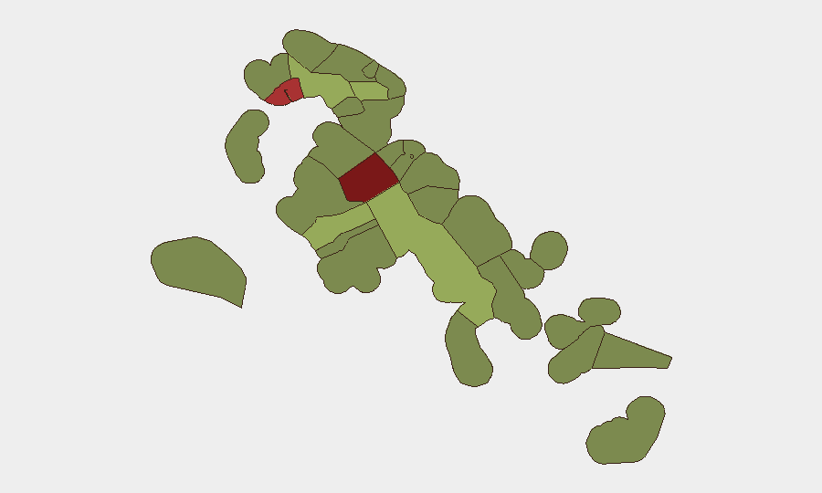
New Providence (risk 92) and City of Freeport (risk 78) dominate the national threat profile, driven by concentrated gang-affiliated homicide, armed robbery, and sexual assault in poorly lit and economically marginalized neighborhoods. Central Abaco (52) and Central Andros (48) register moderate risk, likely reflecting maritime trafficking activity and isolated violent crime. Nassau's "Over the Hill" area—south of Shirley Street—remains the single highest-risk micro-location for corporate personnel and assets. Personnel traveling to or residing in these areas should maintain heightened situational awareness and avoid night movement in target-rich commercial and entertainment zones.
How GeoBit Would Assist
A corporate security team operating in Bahamas would employ AOI Monitoring & Early Warning to establish persistent watch on New Providence and Freeport neighborhoods, triggering alerts on police activity, gang incidents, and infrastructure failures. Multi-language search, X/Twitter OSINT, and sentiment analysis would track local news and social media for emerging crime patterns, political volatility, or maritime trafficking activity ahead of media consolidation. Routing & Network Analysis would support secure personnel movement by identifying alternatives to high-risk corridors and calculating real-time threat exposure during duty-of-care evacuations.
7-Day Outlook
No acute escalation is indicated in the available intelligence for early August. Violent crime in Nassau and Freeport is expected to remain endemic but localized to specific neighborhoods; no new gang territorial conflict, political unrest, or infrastructure emergency is forecasted. Security teams should maintain standard protocols and routine monitoring without material change to travel or asset-protection posture.
Highest-Risk Areas — Ranked
| # | State / Region | Risk |
|---|---|---|
| 1 | New Providence | 92 |
| 2 | City of Freeport | 78 |
| 3 | Central Abaco | 52 |
| 4 | Central Andros | 48 |
| 5 | Exuma | 45 |
| 6 | East Grand Bahama | 42 |
| 7 | South Andros | 38 |
| 8 | North Abaco | 35 |
| 9 | North Eleuthera | 33 |
| 10 | South Abaco | 32 |
| 11 | Cat Island | 30 |
| 12 | Mangrove Cay | 28 |
Sources
Previous Daily Briefs
A new Bahamas brief is written every day — each with its own risk map and downloadable CSV. Here's the last week; use the calendar to go further back.
📅 Browse every day by calendar →
Highlighted days have a brief. Tap a day for that day's map & analysis, or “csv” for that day's dataset ($5).
Atlas — our AI intelligence desk — emails them this snapshot personally. Nothing else, no list.