Situation Summary
Barbados remains a low-threat environment with no validated acute security incidents recorded over the past 48 hours. The nation ranks #181 globally on the GeoBit composite threat index (score 2) with stable conditions reported across all parishes as of 5 August. Grand Kadooment concluded without major public-order disruptions on 4 August, and routine police activity dominates current reporting. The security trajectory is stable with no indicators of imminent escalation.
Key Developments
- Barbados (national), 4 August — Grand Kadooment festival concluded without reported security incidents or public-order flare-ups, confirming event-related risk remained within baseline.
- Bridgetown / Saint Michael, 3–5 August — Open-source monitoring confirmed stable conditions in the primary risk concentration area with no escalation in violent crime, protest activity, or infrastructure disruption during the monitoring window.
- Barbados (national), 8 August — Barbados Police Service issued routine updates including a missing-person notice and an unnatural-death investigation; no new crisis-level incidents or broader unrest indicators emerged in headline coverage.
- Bridgetown / Saint Michael, 8 August — A social-media report referenced a police "crackdown" involving two individuals; insufficient detail available to confirm operational significance or location-specific threat evolution at this time.
- Barbados (national), 3–5 August — Infrastructure monitoring detected no transport, utility, or public-services disruptions affecting normal operational continuity.
Highest-Risk Areas
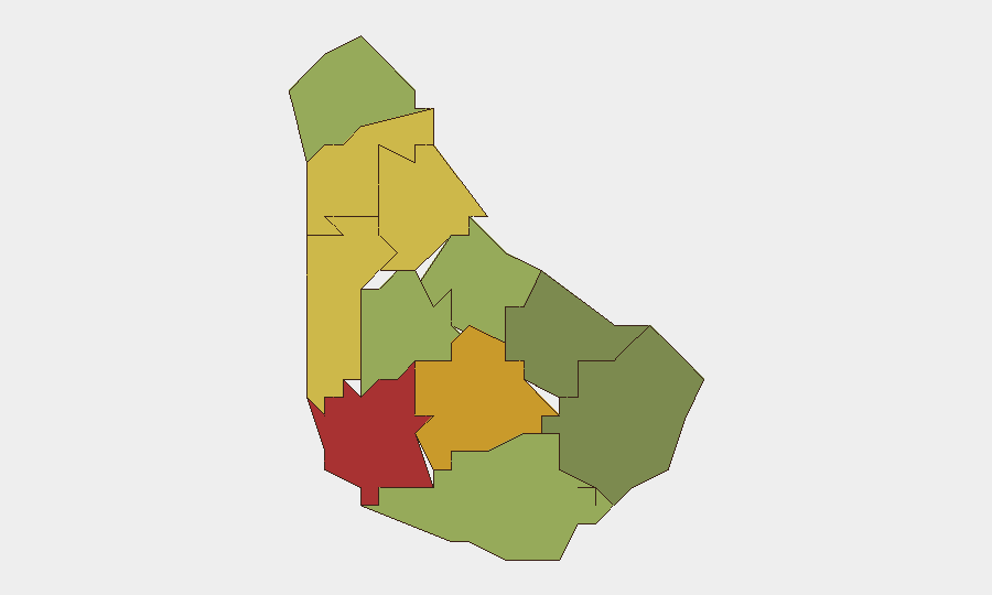
Saint Michael (risk 78) and Saint George (risk 72) drive the sub-national risk profile, with Saint James (68) and Saint Andrew (65) also elevated. Saint Michael's dominance reflects Bridgetown's concentration of commercial activity, transient populations, and historical crime distribution; Saint George's secondary ranking suggests broader western-parish vulnerability. The remaining nine parishes decline progressively in risk score, with Saint Philip (28) and Saint John (35) representing the lowest-threat zones. This geographic gradient reflects urban–rural crime patterns typical of small island economies and warrants concentration of duty-of-care monitoring on western and central parishes.
How GeoBit Would Assist
Security teams should activate Area-of-Interest (AOI) Monitoring with alerting on Saint Michael and Saint George to capture real-time incident emergence and flag escalation before it reaches crisis level. Intel Sweep and multi-language OSINT fusion capabilities enable continuous scanning of local media, police feeds, and social signals to validate or dismiss emerging rumors and maintain accurate situational awareness. For personnel movement or asset routing in higher-risk parishes, Routing & Network Analysis provides validated alternative-journey planning to avoid known crime concentrations and critical infrastructure vulnerabilities.
7-Day Outlook
No significant security disruptions are anticipated in the next seven days; seasonal and event-driven risks (e.g., festival-period crowding) have passed without incident. Barbados is forecast to remain in a stable, low-threat posture unless unexpected civil, infrastructure, or external events emerge. Routine crime monitoring and duty-of-care vigilance remain appropriate baseline practices.
Highest-Risk Areas — Ranked
| # | State / Region | Risk |
|---|---|---|
| 1 | Saint Michael | 78 |
| 2 | Saint George | 72 |
| 3 | Saint James | 68 |
| 4 | Saint Andrew | 65 |
| 5 | Saint Peter | 62 |
| 6 | Saint Joseph | 58 |
| 7 | Saint Thomas | 52 |
| 8 | Saint Lucy | 48 |
| 9 | Christ Church | 42 |
| 10 | Saint John | 35 |
| 11 | Saint Philip | 28 |
Sources
Previous Daily Briefs
A new Barbados brief is written every day — each with its own risk map and downloadable CSV. Here's the last week; use the calendar to go further back.
📅 Browse every day by calendar →
Highlighted days have a brief. Tap a day for that day's map & analysis, or “csv” for that day's dataset ($5).
Atlas — our AI intelligence desk — emails them this snapshot personally. Nothing else, no list.