Situation Summary
Belarus remains a low-frequency acute-incident environment, with composite threat score of 7 and no discrete security events recorded within the last 24–48 hours inside the country itself. Current risk derives primarily from border militarization (particularly the Latvia–Belarus frontier), spillover effects from the Russia–Ukraine conflict affecting Belarusian nationals transiting Russian territory, and persistent state-directed hybrid activity. The operational security picture is stable but contingent on regional dynamics beyond Belarus's borders.
Key Developments
- Latvia–Belarus Border (Ludza, Krāslava, Augšdaugava municipalities): Enhanced Latvian security regime extended through 31 December 2026 (decision reaffirmed 30 June; still in force). Heightened patrols, emergency powers, and tighter movement controls remain in effect in response to irregular migration and hybrid-pressure operations originating from Belarus. Cross-border transit and travel friction expected to persist.
- Russian–Belarusian Border Area, Bryansk Region (Russia): Ukrainian drone strike on Minsk–Anapa passenger bus at checkpoint near Belarus border (2 July; ongoing advisory impact). Belarusian authorities have since advised nationals against travel to Russian border regions. Illustrates elevated risk to Belarus-origin civilian transport near active conflict zone.
- No domestic security incidents, civil unrest, or major infrastructure disruptions recorded in Belarus proper within the last 24–48 hours per available open-source signals.
Highest-Risk Areas
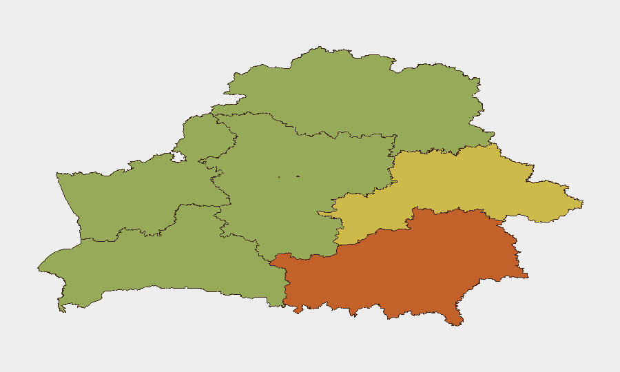
Homyel Region (risk 75) and Minsk (risk 68) dominate the sub-national ranking, driven by proximity to the Ukrainian conflict, border security operations, and concentration of state institutions and international presence respectively. Mahilyow and Brest regions (62 and 55) reflect continued exposure to cross-border hybrid activity and irregular migration pressure. Rural border zones in the north and east carry elevated risk from militarized frontier management and spillover from Russian operations; Minsk Region and Vitsebsk present lower but non-negligible exposure to secondary effects (supply-chain disruption, sanctions compliance, cyber targeting of state entities).
How GeoBit Would Assist
AOI Monitoring & Early Warning on Homyel Region and the Belarus–Ukraine/Russia border corridor would provide persistent watch for military movement, irregular-migration surges, or infrastructure disruption. Intel Sweep and multi-language OSINT fusion (including Telegram, X, and regional media) would capture emerging civil unrest, sanctions enforcement, or state-security operations before mainstream reporting. Routing & Network Analysis would support duty-of-care teams in identifying safe transit corridors and alternative travel arrangements for staff and assets, particularly given Latvia–Belarus border tightening and Russian-zone hazards.
7-Day Outlook
No acute security deterioration is forecast over the next 7 days. Risk trajectory remains dependent on (a) further escalation or de-escalation of Russia–Ukraine conflict intensity and spillover into Russian border regions, and (b) Latvian and other EU border-state responses to hybrid and migration pressure. Belarusian domestic stability is likely to persist absent major regional shock or internal policy shift.
Highest-Risk Areas — Ranked
| # | State / Region | Risk |
|---|---|---|
| 1 | Homyel Region | 75 |
| 2 | Minsk | 68 |
| 3 | Mahilyow Region | 62 |
| 4 | Brest Region | 55 |
| 5 | Hrodna Region | 52 |
| 6 | Minsk Region | 48 |
| 7 | Vitsebsk Region | 45 |
Sources
Previous Daily Briefs
A new Belarus brief is written every day — each with its own risk map and downloadable CSV. Here's the last week; use the calendar to go further back.
📅 Browse every day by calendar →
Highlighted days have a brief. Tap a day for that day's map & analysis, or “csv” for that day's dataset ($5).
Atlas — our AI intelligence desk — emails them this snapshot personally. Nothing else, no list.