Situation Summary
Belize remains at composite threat rank #105 globally, with crime and gang violence as the primary security driver. A concentrated spike in armed violence across Belize City and Cayo District during 2026-08-07 to 2026-08-11—including multiple shootings, a double homicide, armed robberies, and three minors charged with murder—signals a destabilization in the security environment, particularly affecting the Belize District. While no organized extremist or political instability indicators are active, the frequency and lethality of street-level armed crime warrant heightened vigilance for corporate and expatriate populations.
Key Developments
- Belize City, Vernon Street (2026-08-11): Three male minors charged with murder in connection with the shooting death of Ewart Josiah Hernandez Jr.; the killing itself occurred earlier in the week, indicating involvement of juveniles in armed homicides.
- Belize City, multiple locations (2026-08-08): Police reported three separate shooting incidents in a single day, including one double homicide; all cases remain under active investigation, suggesting a spike in retaliatory or gang-related violence.
- San Ignacio, Bullet Tree Road / Puma gas station (2026-08-07): Shooting incident resulted in critical injuries to Carlton McKoy and injuries to an infant; circumstances remain under investigation and details have limited independent corroboration.
- Belize City, Swift Hall (2026-08-07): Fatal shooting during an alleged robbery-related incident; police investigation ongoing.
- Belize District, Haulover Bridge / Philip Goldson Highway (2026-08-11): Search and rescue operation conducted after bee attack; a teenager subsequently reported missing was found dead in the Belize River, raising questions about incident circumstances.
- Belize City (2026-08-07): Police announced intensified operations targeting illegal firearms and narcotics, indicating law-enforcement response to acute armed-crime pressure.
Highest-Risk Areas
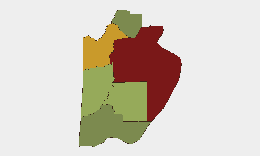
Belize District dominates threat rankings (risk score 95), driven by concentrated armed violence in Belize City and surrounding areas including Vernon Street, Swift Hall, and Lord's Bank Road. Orange Walk District (risk 72) remains elevated but secondary; Cayo District (risk 58) has emerged as a secondary concern following the Bullet Tree Road shooting. Combined, these three districts account for the vast majority of recent violent events and armed robberies. Southern districts (Stann Creek, Toledo, Corozal) show significantly lower risk profiles and remain relatively stable, suggesting violence is geographically concentrated in northern urban centers.
How GeoBit Would Assist
Corporate security teams should employ AOI Monitoring & Early Warning on high-risk neighborhoods (Belize City, Orange Walk Town, San Ignacio) to detect emerging incident clusters and receive real-time alerting when incidents occur near personnel or asset locations. Network & Actor Analysis would map gang structures and known perpetrators involved in recent homicides and robberies, improving threat profiling for movement planning. Routing & Network Analysis capabilities enable identification of lower-risk transit corridors and alternative journey planning that avoids high-incident neighborhoods during peak violence windows.
7-Day Outlook
The recent spike in armed homicides—particularly involving minors—suggests possible gang territorial disputes or retaliation cycles that may sustain elevated violence for 7–14 days. Police intensification operations may temporarily suppress street-level incidents but are unlikely to resolve underlying drivers. Duty-of-care teams should maintain heightened alertness for Belize District operations and consider temporary movement restrictions or safe-house protocols for non-essential travel.
Highest-Risk Areas — Ranked
| # | State / Region | Risk |
|---|---|---|
| 1 | Belize District | 95 |
| 2 | Orange Walk District | 72 |
| 3 | Cayo District | 58 |
| 4 | Stann Creek District | 48 |
| 5 | Toledo District | 35 |
| 6 | Corozal District | 22 |
Sources
Previous Daily Briefs
A new Belize brief is written every day — each with its own risk map and downloadable CSV. Here's the last week; use the calendar to go further back.
📅 Browse every day by calendar →
Highlighted days have a brief. Tap a day for that day's map & analysis, or “csv” for that day's dataset ($5).
Atlas — our AI intelligence desk — emails them this snapshot personally. Nothing else, no list.