Situation Summary
Benin maintains a composite global threat ranking of #54 (score 26/100), reflecting persistent but geographically concentrated security risks. The northern border departments—particularly Alibori, Atakora, Donga, and Borgou—remain the primary concern zones due to recurring extremist incursion and cross-border militant activity originating from the Sahel. No major security incidents have been independently verified inside Benin proper within the last 24–48 hours; current open-source reporting focuses on regional cooperation frameworks and historical threat patterns rather than new, time-stamped events.
Key Developments
- Nigeria–Benin–Niger Tri-Border Military Cooperation (2–3 July 2026, regional announcement). Nigeria's defence ministry announced expanded trilateral military coordination targeting jihadist infiltration routes running through Benin and Niger into Nigeria's northwest. This is a policy response to persistent JNIM and splinter-group activity in the border zone, not a new incident, but signals intensified cross-border security operations that may increase military presence and checkpoint activity in northern Benin departments.
- No internally verified security incidents detected (24–48 hour window). Open web and social-media feeds do not currently surface independently documented unrest, violence, crime, or infrastructure disruptions inside Benin dated to 5–6 July 2026. Regional and historical material (2025 extremist attacks, border talks from June 2026) provide context but fall outside the current reporting window.
- Ongoing northern border volatility (historical context, 2025 forward). JNIM remains the primary extremist actor in northern Benin, responsible for large-scale assaults on Beninese military and paramilitary units in January and April 2025. Though not a new 24–48 hour event, this pattern underpins the elevated risk scores in Alibori, Atakora, Donga, and Borgou departments and justifies heightened vigilance by companies or NGOs operating in those zones.
Highest-Risk Areas
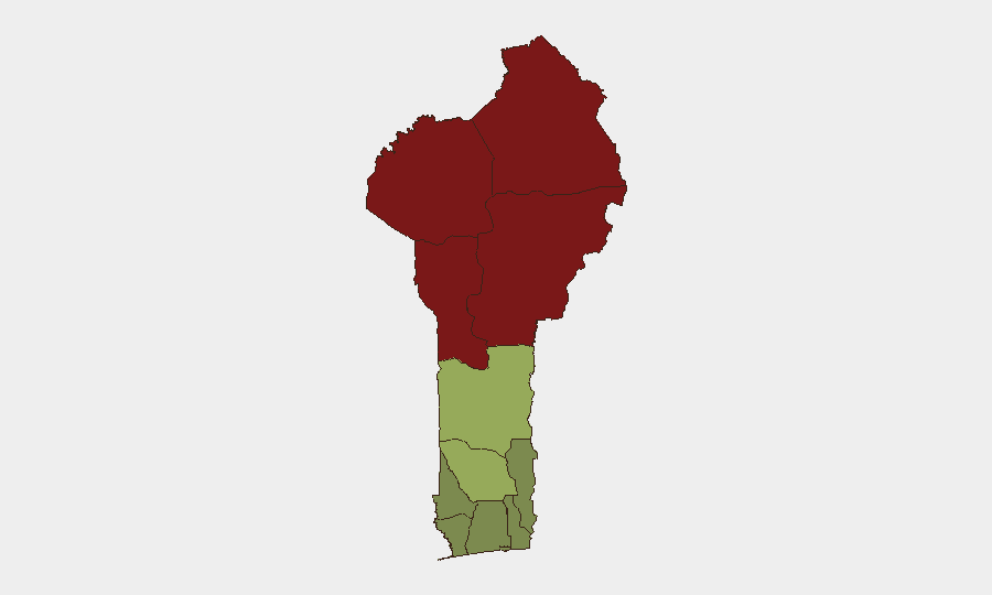
Alibori Department (risk 92) and Atakora Department (risk 88) dominate the sub-national risk profile, driven by proximity to Niger and Burkina Faso borders where JNIM and affiliated jihadist cells operate. Donga (85) and Borgou (83) departments follow closely; all four form a contiguous high-risk corridor in northern Benin where cross-border militant infiltration, military counter-operations, and occasional armed clashes create unpredictable security environments. By contrast, southern and central departments—Ouémé (22), Littoral (25), Atlantique (28)—show significantly lower risk scores and remain substantially safer for business, NGO, and expatriate operations. The gradient reflects both geography (northern border exposure) and state capacity; Cotonou and southern zones benefit from greater government presence and urban policing infrastructure.
How GeoBit Would Assist
Security teams managing personnel or assets in Benin should use AOI Monitoring & Early Warning to maintain persistent watch on Alibori, Atakora, Donga, and Borgou departments, with alert thresholds set for militant activity, armed clashes, or military operations. Network & Actor Analysis and multi-language OSINT fusion (incorporating French-language Sahel and Nigerian sources) would corroborate rumors of cross-border incursions or jihadist movement before they escalate. Routing & Network Analysis can identify safer alternative travel corridors and checkpoint patterns to protect staff transit between Cotonou and northern business sites.
7-Day Outlook
No imminent national-level security crisis is signaled; however, the expanded Nigeria–Benin–Niger military coordination may increase checkpoint density and temporary road restrictions in northern departments over the coming week. Companies and NGOs should prepare for possible temporary mobility constraints in Alibori, Atakora, Donga, and Borgou, and maintain communication with local authorities and security liaisons.
Highest-Risk Areas — Ranked
| # | State / Region | Risk |
|---|---|---|
| 1 | Alibori Department | 92 |
| 2 | Atakora Department | 88 |
| 3 | Donga Department | 85 |
| 4 | Borgou Department | 83 |
| 5 | Zou Department | 45 |
| 6 | Collines Department | 42 |
| 7 | Plateau Department | 38 |
| 8 | Kouffo Department | 35 |
| 9 | Mono Department | 32 |
| 10 | Atlantique Department | 28 |
| 11 | Littoral | 25 |
| 12 | Ouémé Department | 22 |
Sources
Previous Daily Briefs
A new Benin brief is written every day — each with its own risk map and downloadable CSV. Here's the last week; use the calendar to go further back.
📅 Browse every day by calendar →
Highlighted days have a brief. Tap a day for that day's map & analysis, or “csv” for that day's dataset ($5).
Atlas — our AI intelligence desk — emails them this snapshot personally. Nothing else, no list.