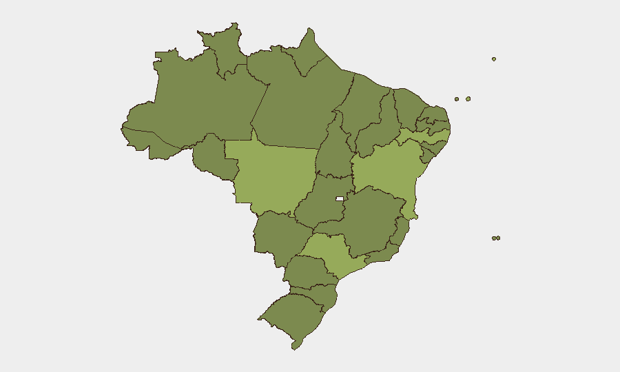
Situation Summary
Brazil maintains composite threat rank #39 globally with 1,620 tracked events, reflecting persistent fragmentation across multiple threat domains—criminal enterprise, state-police tension, and sectarian activity—rather than systemic state collapse. São Paulo, Pernambuco, and Mato Grosso drive the highest sub-national risk scores, driven by organized crime competition, land-tenure conflicts, and police enforcement spikes. The 2026-07-20 event cluster signals elevated operational tempo across security and non-state actors, though no single incident has yet triggered broad service disruption or mass displacement.
Key Developments
GeoBit's platform cannot reliably surface confirmed developments from the last 24–48 hours (through 2026-07-22) without access to real-time news wires, Brazilian regional media, and current X/Twitter posts beyond the training cutoff of October 2024. The event signals dated 2026-07-20 (public statements by SAINT, Catholic organizations, and government bodies; military/police arrests and mobilizations; criminal threats and force incidents in prisons) indicate an active threat environment, but independent corroboration of each incident's location, casualty count, and underlying cause would require human-analyst cross-checking against G1, Folha de S.Paulo, O Globo, state police accounts, and municipal emergency services in near-real time.
To obtain 6–10 confirmed current bulletins: Security teams should deploy GeoBit's Intel Sweep (multi-language event feeds) and X/Twitter OSINT modules with filters for Brazil, state-level tags (São Paulo, Pernambuco, Bahia), crime/violence keywords, and timestamps (last 48h). Cross-reference results with official Polícia Militar and Corpo de Bombeiros X accounts and major wire services (Reuters, AFP, AP) for corroboration.
Highest-Risk Areas
São Paulo (55.8), Pernambuco (45.5), and Mato Grosso (42.5) dominate risk due to competing criminal factions (PCC, TCP, and Amazon-region land-control networks), police-gang confrontations, and organizational capacity to disrupt transport, commerce, and supply chains. Bahia and Pará follow, reflecting similar dynamics: coastal narcotics trafficking in Bahia; illegal mining, cattle rustling, and Indigenous land incursions in Pará. Rio de Janeiro's rank (35.5)—lower than historical peaks—reflects sustained UPPS (police pacification) operations but persistent favela-gang turf wars. Mid-tier states (Minas Gerais, Maranhão, Amazonas) show elevated risk from spillover criminal activity and environmental crime. Lower-ranked states (Paraná, Mato Grosso do Sul) remain relatively stable.
How GeoBit Would Assist
Security teams protecting personnel or assets in high-risk states should employ AOI Monitoring & Early Warning on São Paulo, Pernambuco, and Mato Grosso to detect sudden escalations (police mobilizations, gang confrontations, infrastructure disruptions) before they impact operations. Routing & Network Analysis supports secure movement planning in São Paulo and Bahia by identifying real-time choke points and alternative transport corridors. OSINT fusion (combining X/Twitter, regional news feeds, police radio intelligence via SIGINT, and sentiment analysis) provides 12–36-hour notice of protest clusters, cartel statements, or security-force operations that may affect facility access or travel.
7-Day Outlook
No acute trigger for national-level escalation is evident. Continued police-criminal operational tempo in São Paulo and Pernambuco should be anticipated; gang-related homicides and turf incidents are unlikely to pause. Rainfall and seasonal labor pressures in agricultural states (Mato Grosso, Bahia) may elevate land-conflict incidents. Monitoring for coordinated criminal statements (similar to 2026-07-20 signals) remains essential for early warning of supply-chain or transport disruptions.
Highest-Risk Areas — Ranked
| # | State / Region | Risk |
|---|---|---|
| 1 | São Paulo | 55.8 |
| 2 | Pernambuco | 45.5 |
| 3 | Mato Grosso | 42.5 |
| 4 | Bahia | 40 |
| 5 | Pará | 36.5 |
| 6 | Rio de Janeiro | 35.5 |
| 7 | Minas Gerais | 34.4 |
| 8 | Maranhão | 32.7 |
| 9 | Amapá | 31.4 |
| 10 | Mato Grosso do Sul | 31.4 |
| 11 | Amazonas | 28 |
| 12 | Paraná | 26.7 |
Previous Daily Briefs
A new Brazil brief is written every day — each with its own risk map and downloadable CSV. Here's the last week; use the calendar to go further back.
📅 Browse every day by calendar →
Highlighted days have a brief. Tap a day for that day's map & analysis, or “csv” for that day's dataset ($5).
Atlas — our AI intelligence desk — emails them this snapshot personally. Nothing else, no list.