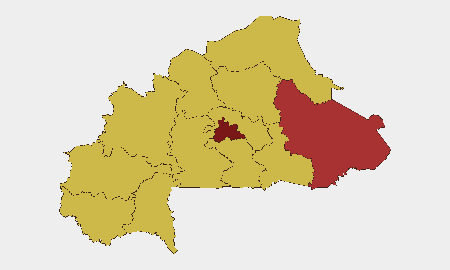
Situation Summary
Burkina Faso remains at Global Threat Rank #7 with a composite score of 100, driven by sustained armed-group activity in the eastern and central zones, acute institutional strain within the government, and rapid diplomatic isolation from Western partners. The last 48 hours have witnessed a formal diplomatic downgrade with France, a military confrontation with domestic activists, the arrest of a US citizen, and a major claimed military engagement in the northeast—all signaling concurrent pressures from armed opposition, internal governance friction, and international estrangement. The trajectory points toward tightening state control, possible further Western withdrawal, and heightened risk for Western nationals and corporate interests.
Key Developments
- Gayéri, Solhan, Sebba (Sirba/Liptako, East/Northeast) – 30 June, reported 2–3 July 2026: Burkina Faso's armed forces announced repulsion of coordinated multi-site attacks, claiming over 400 armed men killed and seizure of 250+ motorcycles and substantial ordnance. Official statements accused France of orchestrating the attacks as retaliation for the 26 June diplomatic break.
- Ouagadougou (National) – 3 July 2026: Formal diplomatic downgrade with France confirmed via official government statements, solidifying the break announced 26 June and reducing bilateral cooperation in security and political domains.
- Ouagadougou (Digital/Institutional) – 3 July 2026: A "Website vs Google" investigation flagged tensions between Burkinabè authorities and a major tech platform, reflecting state friction over online information control and foreign digital platforms in the context of perceived "information warfare."
- Ouagadougou (Parliament/Executive) – 2 July 2026: Public disagreement between Prime Minister and Parliament recorded, signaling institutional strain within the military-led government.
- Unspecified location, Burkina Faso – 2 July 2026: Conventional military forces deployed against activist(s); indicators of state security response to domestic opposition and civil unrest.
- Ouagadougou (National) – 2 July 2026: Arrest/detention of a US citizen or entity reported, escalating bilateral friction between Burkina Faso and the United States and signaling tightening toward Western actors.
- Ouagadougou (Security Institutions) – 2 July 2026: Internal conflict between Prosecutor and Police recorded, suggesting institutional dysfunction within the state security apparatus.
- International/Sectoral – 2 July 2026: UK and Bahamian parliamentary statements, plus airway-sector criticism, amplified on social media, reflecting mounting international and sectoral opposition to government posture.
Highest-Risk Areas
Centre region dominates the sub-national ranking at risk score 100, followed by East at 77.5 and a cluster of nine regions at 70. The Centre's concentration of government infrastructure and population, combined with militant pressure from surrounding zones, makes it the focal point for both armed-group activity and state counter-operations. East region, encompassing the Sirba/Liptako borderlands, remains the primary theatre of conventional military confrontation between armed groups and state forces. The remaining high-risk zones form a contiguous arc across the north, northwest, and southern tiers, indicating sustained territorial challenge to state control across much of the country's interior.
How GeoBit Would Assist
Security teams should employ AOI Monitoring & Early Warning on Centre and East regions to track militant movements, checkpoint activity, and force concentrations in near real-time. Network & Actor Analysis and multi-language OSINT (X, Telegram, Facebook, local radio SIGINT) will surface emerging activist, military, and government-faction communications and friction points before escalation. GIS & Spatial Analysis and battle mapping will correlate reported military engagements (e.g., Gayéri, Solhan) with personnel-movement risk and supply-route viability.
7-Day Outlook
Further diplomatic friction with France and Western capitals is likely, possibly including additional asset freezes, visa restrictions, or security-sector sanctions. Internal tensions between Parliament and the executive, combined with military operations against activists, suggest possible further detentions or restrictions on foreign nationals. Armed-group activity in East and Centre regions will remain persistent; no immediate large-scale de-escalation is forecast in the near term.
Highest-Risk Areas — Ranked
| # | State / Region | Risk |
|---|---|---|
| 1 | Centre | 100 |
| 2 | East | 77.5 |
| 3 | Upper-Basins | 70 |
| 4 | Boucle du Mouhoun | 70 |
| 5 | Central-West | 70 |
| 6 | Central-South | 70 |
| 7 | Central-East | 70 |
| 8 | Waterfalls | 70 |
| 9 | Southwest | 70 |
| 10 | Sahel | 70 |
| 11 | Central-North | 70 |
| 12 | North | 70 |
Sources
Previous Daily Briefs
A new Burkina Faso brief is written every day — each with its own risk map and downloadable CSV. Here's the last week; use the calendar to go further back.
📅 Browse every day by calendar →
Highlighted days have a brief. Tap a day for that day's map & analysis, or “csv” for that day's dataset ($5).