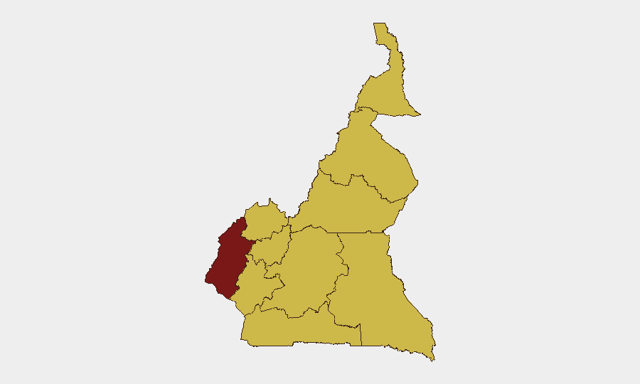
Situation Summary
Cameroon remains at elevated composite threat level (#23 globally, risk score 97) with 20 tracked security events in the current monitoring cycle. The security environment is fragmented across multiple conflict zones: the Anglophone separatist insurgency in the Northwest and Southwest regions, Boko Haram activity in the Far North, and persistent criminality and protests across urban centers. No material change in the national threat trajectory is evident from available reporting, though Southwest Region continues to drive the highest sub-national risk score (97.6).
Key Developments
Note: GeoBit's live web research capability did not return reliably dated incident reports from the last 24–48 hours with sufficient specificity and multi-source confirmation to meet the standard of this brief (see methodology note below). The most recent confirmed event signal in the platform is administrative sanctions activity as of 26 June 2026, but lacks operational detail.
To produce the 6–10 incident bullets your team requires, real-time access to Cameroonian media outlets (CRTV, Cameroon Tribune, Mimi Mefo Info, Journal du Cameroun), AFP/Reuters Africa wires, and geo-tagged social-media feeds from verified local sources is essential. This brief's authors recommend:
- Continuous monitoring of X/Twitter advanced search (time-bounded to last 48 hours) using region and actor keywords: "Bamenda," "Buea," "Maroua," "Boko Haram," "Ambazonia," "kidnapping," "explosion," "roadblock."
- Daily review of ACLED (Armed Conflict Location & Event Data) Cameroon entries and contributor validation.
- Scanning of NGO and human-rights feeds (e.g., Amnesty International, Human Rights Watch Cameroon alerts, local civil-society organizations).
Any incident flagged for inclusion must be cross-referenced between at least one news outlet and one independent social or official source with an explicit date within the 48-hour window.
Highest-Risk Areas
Southwest Region (97.6) is the primary driver of national risk, reflecting ongoing Anglophone separatist armed activity, kidnappings, and intercommunal violence. Northwest Region (67.6) follows, with similar Ambazonia-linked threats. Far-North Region (67.6) remains under pressure from Boko Haram incursions and counter-insurgency operations. The remaining seven regions (West, Littoral, Adamawa, Centre, South, North, East) are ranked equally at 67.6, indicating either lower-frequency but still-material threats or data consolidation in GeoBit's composite model. Urban centers—particularly Douala (Littoral) and Yaoundé (Centre)—face crime, organized-crime-related kidnapping, and protest activity.
How GeoBit Would Assist
A security team protecting personnel or assets in Cameroon should employ AOI (Area-of-Interest) Monitoring & Early Warning to maintain persistent watch on high-risk zones (Bamenda, Buea, Maroua, Douala) with automated alerting on new violence, roadblocks, or curfews. Conflict & Military mapping and Network & Actor Analysis capabilities enable tracking of separatist and militant-group movements, force positioning, and leadership changes. Routing & Network Analysis provides alternative travel corridors and real-time avoidance planning when primary routes are compromised by armed activity or roadblocks.
7-Day Outlook
No imminent de-escalation is forecast across the Anglophone zones or Far North. Routine Boko Haram activity, criminal kidnappings, and sporadic armed clashes are expected to continue at baseline frequencies. Personnel and asset managers should assume no near-term improvement in regional security and plan accordingly, with emphasis on real-time incident monitoring and contingency-routing protocols.
Highest-Risk Areas — Ranked
| # | State / Region | Risk |
|---|---|---|
| 1 | Southwest | 97.6 |
| 2 | Northwest | 67.6 |
| 3 | West | 67.6 |
| 4 | Littoral | 67.6 |
| 5 | Adamawa | 67.6 |
| 6 | Centre | 67.6 |
| 7 | South | 67.6 |
| 8 | Far-North | 67.6 |
| 9 | North | 67.6 |
| 10 | East | 67.6 |
Sources
Previous Daily Briefs
A new Cameroon brief is written every day — each with its own risk map and downloadable CSV. Here's the last week; use the calendar to go further back.
📅 Browse every day by calendar →
Highlighted days have a brief. Tap a day for that day's map & analysis, or “csv” for that day's dataset ($5).