Situation Summary
Chad remains ranked #17 globally in composite threat exposure (score 99), with 22 tracked events in the monitoring period. Open-source reporting for the last 24–48 hours does not surface new, corroborated security incidents, civil unrest, or acute conflict activity. However, underlying vulnerabilities—including border instability in the Lake Chad region, political tension with external actors (as reflected in recent diplomatic disapprovals), and persistent health risks—maintain elevated baseline risk across multiple regions.
Key Developments
- 2026-06-24 · Arrest/Detention (N'Djamena vicinity) – A detention event reported involving a detective; specific circumstances, location, and individuals remain unclear from available open sources. Monitor for follow-on statements or judicial proceedings.
- 2026-06-23 · Diplomatic Disapproval (bilateral) – Multiple instances of U.S. disapproval directed at Chad government; concurrent disapproval from Chad toward U.S. signals diplomatic friction. Underlying cause(s) not yet specified in corroborated reporting; may reflect counter-terrorism cooperation disputes or governance concerns.
- 2026-06-23 · Third-Party Statement (MEDINA entity) – A public statement from MEDINA regarding Chad; context and substance not yet clarified in available English-language reporting.
- Ongoing · Hepatitis E Circulation – Health alert for Hepatitis E in Chad; relevant for personnel welfare and medical readiness planning, particularly in remote or under-resourced regions.
- No corroborated acute security incidents (last 24–48 hours) – Web research and open-source monitoring detected no verifiable reports of armed clashes, mass protests, criminal upsurge, or infrastructure disruption within the last 24–48 hours. Social media references to "recent" Boko Haram incidents in Chad (mentioning casualty counts) lack confirmed dates and likely predate the current 48-hour window.
Highest-Risk Areas
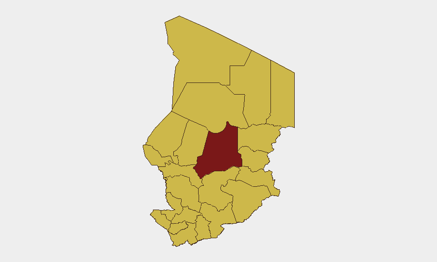
Batha region dominates the sub-national risk profile (99.2), reflecting ongoing instability and recurring militant activity in this northern and northeastern zone. The remaining 11 tracked regions cluster at 69.2 composite risk, indicating broad geographic vulnerability rather than isolated hotspots. Batha's elevated score correlates with historical Boko Haram and ISIS-affiliated group presence, desert-terrain governance challenges, and cross-border flows. N'Djamena, despite its capital status, carries equivalent baseline risk (69.2) due to its role as a political and administrative node where tensions escalate; security force actions and detention activity (as noted above) underscore this exposure. Lake Chad basin regions (Lac, Kanem, Hadjer-Lamis) remain migration and trafficking corridors with intermittent militant recruitment and criminal networks. East-central zones (Wadi Fira, Ouaddaï, Sila) face similar vulnerabilities but lower recorded event frequency.
How GeoBit Would Assist
Corporate security teams operating in Chad should prioritize Intel Sweep and OSINT fusion to monitor diplomatic tone, detention activity, and security-force posture in real time, focusing on N'Djamena and Batha. AOI Monitoring & Early Warning on border crossings, Lake Chad littoral zones, and key transport corridors (with persistent alerting) would enable advance notice of militant movement or organized crime surges before they impact personnel or logistics. Conflict mapping and actor-network analysis of Boko Haram splinter groups and militia activity—combined with alternative routing & journey planning—should inform travel-risk mitigations for field teams and supply convoys.
7-Day Outlook
Near-term trajectory remains stable but brittle. Diplomatic friction between Chad and Western partners may drive policy shifts (e.g., sanctions, aid conditionality, or counter-terrorism coordination changes) that indirectly increase security-force volatility or create enforcement/detention spikes. Boko Haram and successor groups typically conduct operations in seasonal patterns; summer months do not historically show peak activity, though recruitment and planning cycles continue. Monitor for any escalation linked to the detention event or diplomatic developments in the coming 3–5 days.
Highest-Risk Areas — Ranked
| # | State / Region | Risk |
|---|---|---|
| 1 | Batha | 99.2 |
| 2 | Ennedi-Ouest | 69.2 |
| 3 | Wadi Fira | 69.2 |
| 4 | Ouaddaï | 69.2 |
| 5 | Sila | 69.2 |
| 6 | Salamat | 69.2 |
| 7 | East Ennedi | 69.2 |
| 8 | Kanem | 69.2 |
| 9 | Lac | 69.2 |
| 10 | N'Djamena | 69.2 |
| 11 | Hadjer-Lamis | 69.2 |
| 12 | Chari-Baguirmi | 69.2 |
Sources
Previous Daily Briefs
A new Chad brief is written every day — each with its own risk map and downloadable CSV. Here's the last week; use the calendar to go further back.
📅 Browse every day by calendar →
Highlighted days have a brief. Tap a day for that day's map & analysis, or “csv” for that day's dataset ($5).