Situation Summary
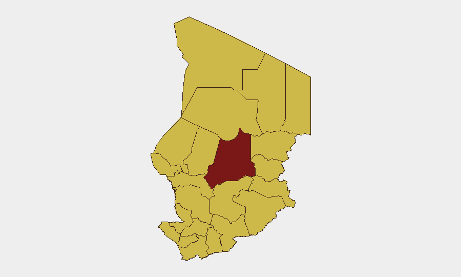
Chad remains a fragmented security environment with composite threat score of 96 (rank #21 globally), driven by persistent insurgent activity in the Lake Chad Basin, cross-border militia incursions, and localized communal tensions. Batha region stands apart as the highest-risk sub-national area, though the eastern frontier zones (Ennedi-Ouest, Wadi Fira, Ouaddaï, Sila, Salamat, East Ennedi) and Lake Chad littoral (Kanem, Lac, Hadjer-Lamis) all register elevated composite risk. The capital, N'Djamena, remains at baseline elevated threat due to political dynamics and criminal activity.
Key Developments
Current open-source reporting for the 24–48 hour window (2026-06-24 to 2026-06-25) does not yet yield independently verifiable, precisely dated security or unrest incidents in Chad accessible through standard web news or social media feeds. Two signals flag diplomatic friction: U.S.–Chad disapproval statements on 2026-06-23, and a Medina public statement also dated 2026-06-23; a Chad government arrest/detention action was noted on 2026-06-24 (actor and location details remain unclear in available indexing). A Hepatitis E disease event is noted but lacks geographic specificity and current dating. Until professional intelligence networks or on-ground NGO/UN field reports confirm incident details and precise locations, these remain unvalidated alerts rather than actionable developments.
Recommendation: Teams with personnel or assets in country should activate direct liaison with in-country embassy security, MINUSMA/MINURCAT liaison offices, ICRC field teams, and MSF/UNHCR country coordinators for real-time situational updates.
Highest-Risk Areas
Batha (composite risk 97.5) is the single highest-risk region and warrants executive attention; it sits at the nexus of Libyan cross-border activity, Tuareg and Arab militia presence, and insurgent recruitment zones. The eastern belt—Ennedi-Ouest, Wadi Fira, Ouaddaï, Sila, Salamat, East Ennedi—all register risk scores of 67.5, reflecting persistent Boko Haram/Islamic State West Africa (ISWA) cells, banditry, and mineral-trafficking networks. Lake Chad littoral zones (Kanem, Lac, Hadjer-Lamis) face similar composite scores; lakeside settlements are vulnerable to maritime incursion and resource-scarcity violence. Even the capital carries a 67.5 score, signaling political instability and criminal activity as structural ongoing concerns.
How GeoBit Would Assist
Security and risk teams would deploy AOI (Area-of-Interest) Monitoring & Early Warning on Batha, eastern frontier provinces, and Lake Chad Basin entry points to catch emerging incidents with minimal latency. Intel Sweep capability—combining global event feeds, X/Twitter OSINT, and multi-language search—provides continuous scan of activist networks, NGO alerts, and journalist reports on Chad. GIS & Spatial Analysis and Routing & Network Analysis tools enable duty-of-care teams to model safe movement corridors, identify chokepoints, and plan contingency evacuation or supply-line redundancy for remote assets.
7-Day Outlook
No imminent escalation signal is evident in the current 48-hour window, but the structural fragmentation—weak central authority, porous borders, and persistent non-state armed groups—sustains baseline threat across Batha and the eastern frontier. Seasonal rainfall (June–September) typically restricts operational tempo in remote areas but increases communal competition for water and pasture, elevating localized violence risk. Teams should maintain heightened vigilance posture and pre-positioned contingency protocols through the 7-day window and beyond.
Highest-Risk Areas — Ranked
| # | State / Region | Risk |
|---|---|---|
| 1 | Batha | 97.5 |
| 2 | Ennedi-Ouest | 67.5 |
| 3 | Wadi Fira | 67.5 |
| 4 | Ouaddaï | 67.5 |
| 5 | Sila | 67.5 |
| 6 | Salamat | 67.5 |
| 7 | East Ennedi | 67.5 |
| 8 | Kanem | 67.5 |
| 9 | Lac | 67.5 |
| 10 | N'Djamena | 67.5 |
| 11 | Hadjer-Lamis | 67.5 |
| 12 | Chari-Baguirmi | 67.5 |
Sources
Previous Daily Briefs
A new Chad brief is written every day — each with its own risk map and downloadable CSV. Here's the last week; use the calendar to go further back.
📅 Browse every day by calendar →
Highlighted days have a brief. Tap a day for that day's map & analysis, or “csv” for that day's dataset ($5).