Situation Summary
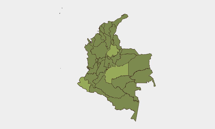
Colombia remains a composite-threat environment (#35 globally) with persistent armed-group activity, illegal economy control, and state fragmentation across rural zones, offset by functional governance and security operations in major urban centers. The 21 June 2026 presidential runoff is driving a temporary, measurable elevation in security posture—particularly in Bogotá—with 15,000+ police and civilian officials deployed to manage election-day contingencies and mitigate disruption risks. Capital District, Meta, and Nariño departments carry the highest risk profiles; rural instability in coca-producing and illegal-mining zones remains structural. No major security incidents have been reliably confirmed in open sources within the past 48 hours, though authorities are preparing defensively rather than reactively.
Key Developments
- Bogotá (Capital District) – 18–19 June 2026: Colombian authorities announced and began implementing enhanced security operations ahead of the 21 June presidential runoff, deploying approximately 12,500 national police officers and 2,500 district-level officials across the capital. A special emergency coordination center and Unified Command Post (PMU) are being activated in each of the city's 20 localities to manage potential disruptions to electricity, telecoms, transport, water, and traffic. This deployment represents a material shift in security posture and reflects institutional assessment of election-period risk, though no specific incident triggered the escalation.
- National – 19–20 June 2026: Multiple official statements from Colombian government bodies (presidential office, ministry, authorities, foreign ministry) and institutional actions (investigations referenced) indicate heightened diplomatic and administrative activity, though open-source material does not yet confirm specific operational incidents or threat reporting underlying these actions.
- Wider context (prior weeks, for operational planning): Armed-group expansion, coca-economy competition, and illegal mining remain active in Meta, Nariño, Cauca, and Catatumbo zones, creating persistent risk for overland movement and remote-area operations, but no discrete incidents have been time-anchored to 19–20 June in available public reporting.
Highest-Risk Areas
Capital District (55.2), Meta (54.5), and Nariño (52.8) departments drive the top-three risk composite scores. Bogotá's rank reflects election-period volatility, institutional activity, and urban-crime vectors; Meta and Nariño are characterized by armed-group territorial control, coca cultivation, and dispute over illegal-economy zones. Santander (43.7) and Cauca (33.9) follow, with Cauca historically linked to ethnic-armed and criminal-organization violence. Atlántico, Cundinamarca, and Antioquia remain elevated but materially lower; peripheral zones (Chocó, Amazonas, Guainía) show chronic instability but lower absolute event frequency in current tracking. For corporate operations, the Capital District elevation is temporary and election-linked; Meta and Nariño present persistent structural risk requiring long-term protective and routing measures.
How GeoBit Would Assist
Security teams can deploy AOI Monitoring & Early Warning on Capital District, Meta, and Nariño to receive real-time alerts on protest, security force activity, and transport disruptions; simultaneously, Intel Sweep and multi-language OSINT fusion (X/Twitter, local media, Telegram) will cross-confirm incident reporting and filter noise from official statements. Routing & Network Analysis can generate and update alternative travel paths for personnel and supply chains in Cauca and Catatumbo, accounting for armed-group presence and roadblock risk. Election Monitoring capabilities will track disruption vectors around the 21 June runoff in Bogotá and key provincial cities.
7-Day Outlook
The 21 June presidential runoff will remain the primary security variable; elevated police presence and command-and-control measures in Bogotá are expected to suppress major disruption, though localized protests or transport friction remain possible. Post-election stabilization or political contestation will likely determine whether current deployment levels persist. Rural armed-group and illegal-economy activity will continue unchanged, with no near-term policy or enforcement shift anticipated to reduce structural risk in Meta, Nariño, or Cauca.
Highest-Risk Areas — Ranked
| # | State / Region | Risk |
|---|---|---|
| 1 | Capital District | 55.2 |
| 2 | Meta Department | 54.5 |
| 3 | Nariño | 52.8 |
| 4 | Santander Department | 43.7 |
| 5 | Cauca | 33.9 |
| 6 | Atlántico Department | 33.2 |
| 7 | Cundinamarca Department | 32.2 |
| 8 | Antioquia Department | 28 |
| 9 | Guainía Department | 26.6 |
| 10 | Bolívar Department | 26.6 |
| 11 | Amazonas | 26.2 |
| 12 | Chocó Department | 26.2 |
Sources
Previous Daily Briefs
A new Colombia brief is written every day — each with its own risk map and downloadable CSV. Here's the last week; use the calendar to go further back.
📅 Browse every day by calendar →
Highlighted days have a brief. Tap a day for that day's map & analysis, or “csv” for that day's dataset ($5).