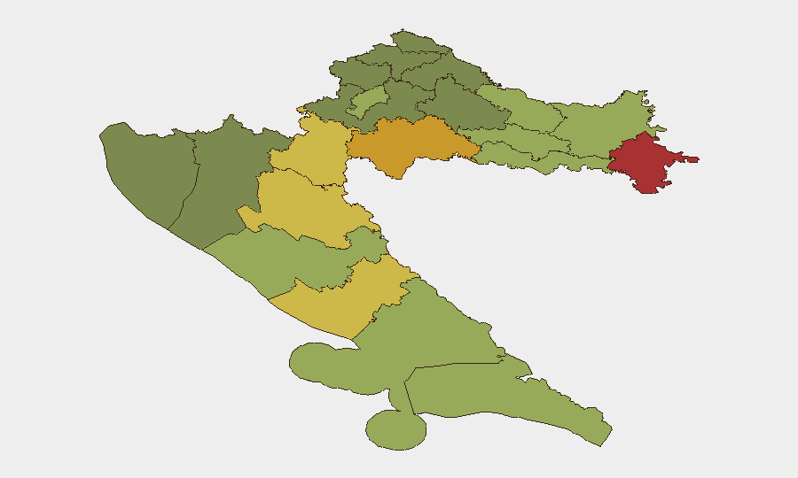
Situation Summary
Croatia remains a low-threat environment (global rank #127, composite score 6) with no major acute security incidents in the past 48 hours. The primary current risks are environmental—a contained wildfire on Korčula Island and extreme heat across the southern Adriatic—and disruptive rather than violent: an elevated frequency of bomb threats against public facilities and transport hubs. Border crossing delays linked to Schengen procedural checks present a travel friction factor, but overall security posture warrants only routine precautions.
Key Developments
- Korčula Island wildfire (Dalmatia), overnight 11–12 July 2026: Firefighters contained a blaze aided by overnight rainfall; no casualties reported. Local short-term disruption risk remains (smoke, possible road/transport closures, emergency operations strain), but no mass evacuation occurred.
- Nationwide bomb threats advisory (current as 12 July 2026): Australian Smartraveller and other official travel advisories confirm an *increasing* frequency of bomb threats against public areas, transport hubs, and facilities. Threats remain largely unverified/malicious, but trigger temporary evacuations and closures of public spaces.
- Border crossing delays (current as 12 July 2026): Schengen-area entry/exit rule changes and procedural checks are creating potential queues and delays at land, air, and sea border checkpoints; no specific incident but a systemic travel-friction factor.
- Extreme heat conditions (Dalmatian coast, 11–12 July 2026): Heat stress contributed to wildfire ignition on Korčula and poses elevated environmental/health risk for outdoor activity, power/water infrastructure strain, and potential secondary incidents across the southern Adriatic.
- Croatia–Serbia diplomatic disapprovals (11 July 2026): Routine bilateral statements of disapproval recorded; no escalation or incident cited. Background tension remains stable.
- Ministry investigations and police statements (12–13 July 2026): Official statements and investigations were announced but specific details remain opaque in open sources; no major incident implied by current advisories.
Highest-Risk Areas
Eastern and southern border regions drive the sub-national ranking. Vukovar-Srijem, Sisak-Moslavina, and Karlovac counties (ranks 1–3, risk scores 78, 72, 68) are elevated owing to proximity to the Serbian border, historical legacy of conflict, and ongoing border management and demographic sensitivities. Lika-Senj and Šibenik-Knin counties (ranks 4–5) share similar border-adjacent risk profiles. By contrast, Zagreb city and Split-Dalmatia county (ranks 9–10, scores 50, 48) show lower risk indices despite larger populations, reflecting greater institutional capacity and lower border/territorial tension. The ranking reflects geography (border proximity) and historical conflict legacies rather than acute current incidents.
How GeoBit Would Assist
Security teams would employ Intel Sweep and global event feeds to maintain real-time alerting on the 15 tracked events in Croatia and flag threshold changes in the composite score. AOI Monitoring & Early Warning on high-risk counties—particularly Vukovar-Srijem and Sisak-Moslavina—would provide persistent watch on border activity, civil unrest, or infrastructure disruptions. Satellite & Imagery analysis could corroborate wildfire status and assess transport/infrastructure impact, while Routing & Network Analysis would support duty-of-care teams in identifying safe overland and transit alternatives during border delays or environmental events.
7-Day Outlook
Heat conditions and wildfire risk are expected to persist through mid-July across the Adriatic; cooler patterns forecast by mid-to-late July may ease environmental strain. Bomb-threat frequency is unlikely to decline without operational security interventions; continued elevated vigilance at public facilities should be expected. Border procedures are stable and non-escalatory; no major political or security deterioration is forecast.
Highest-Risk Areas — Ranked
| # | State / Region | Risk |
|---|---|---|
| 1 | Vukovar-Srijem County | 78 |
| 2 | Sisak-Moslavina County | 72 |
| 3 | Karlovac County | 68 |
| 4 | Lika-Senj County | 65 |
| 5 | Šibenik-Knin County | 62 |
| 6 | Brod-Posavina County | 58 |
| 7 | Zadar County | 55 |
| 8 | Osijek-Baranja County | 52 |
| 9 | City of Zagreb | 50 |
| 10 | Split-Dalmatia County | 48 |
| 11 | Požega-Slavonia County | 45 |
| 12 | Virovitica-Podravina County | 42 |
Sources
Previous Daily Briefs
A new Croatia brief is written every day — each with its own risk map and downloadable CSV. Here's the last week; use the calendar to go further back.
📅 Browse every day by calendar →
Highlighted days have a brief. Tap a day for that day's map & analysis, or “csv” for that day's dataset ($5).
Atlas — our AI intelligence desk — emails them this snapshot personally. Nothing else, no list.