Situation Summary
Cyprus remains a low-threat environment with no reported security incidents, civil unrest, or terrorism activity in the past 24–48 hours. Current operational risk is dominated by environmental hazards—island-wide red-alert forest-fire conditions and dangerous heat—and routine transport disruptions from vehicle accidents. An ongoing terrorism investigation in Larnaca involving four detained suspects remains in the judicial phase with no new operational developments reported; the overall security trajectory is stable.
Key Developments
- Islandwide, Cyprus – July 22, 2026
Department of Labour mandated a temporary halt to outdoor manual work from 12:00–16:00 due to dangerous heat conditions, affecting worker safety and occupational continuity across multiple sectors.
- All districts, Cyprus – July 22–23, 2026
Authorities issued a red-alert forest-fire warning islandwide, citing extremely high likelihood of fire ignition and spread; public activity restrictions in forested and rural areas are in effect.
- Limassol–Paphos motorway near Paramali – July 22, 2026
Police closed the motorway in the Paphos direction following a collision between a passing vehicle and a road-marking vehicle, causing significant intercity traffic disruption; closure was non-criminal and temporary.
- Nicosia–Limassol highway – July 23, 2026 (afternoon)
Both lanes were closed after a gravel-laden lorry overturned and spilled cargo across the road, disrupting travel on a primary island artery; incident was infrastructure-related with no security indicators.
- Larnaca – ongoing as of July 23, 2026
Ongoing terrorism investigation continues with four suspects in custody; no new arrests or operational incidents reported in the last 24–48 hours beyond mid-July detentions announced previously.
Highest-Risk Areas
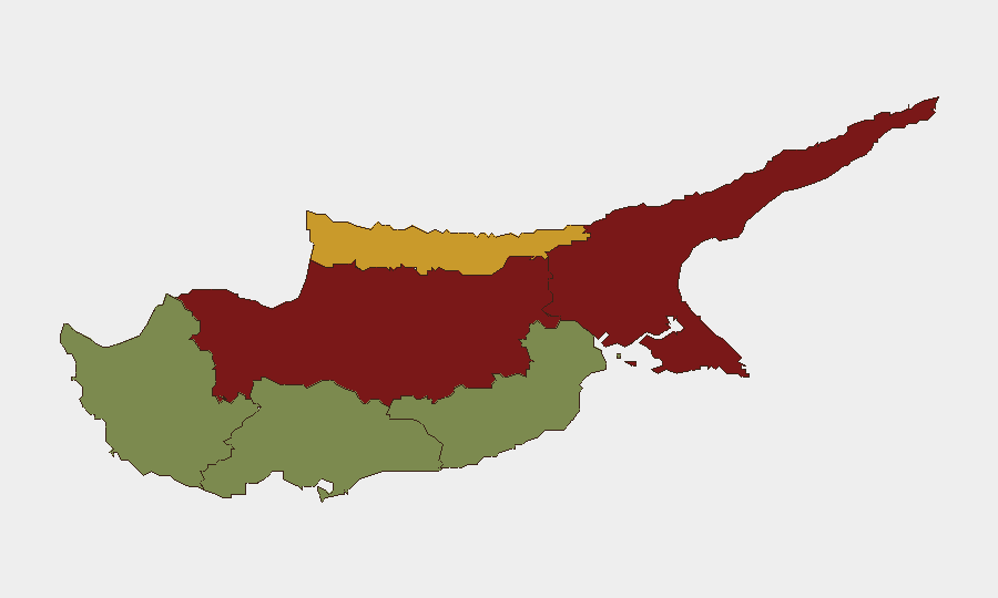
Nicosia and Famagusta dominate the sub-national risk profile (scores 92 and 88 respectively), reflecting the capital's administrative density, migrant and transient populations, and the legacy political division along the Green Line. Kyrenia (score 72) follows as a secondary concern. The gap between these three and southern coastal districts (Larnaca, Limassol, Paphos—scores 28, 22, 18) reflects concentration of policing, judicial, and investigative activity in and around Nicosia, as well as lower reported incident frequency in tourism and commercial hubs. Risk in the north remains latent rather than acute, with no active conflicts or imminent security events signaled in current reporting.
How GeoBit Would Assist
Corporate security teams should deploy AOI Monitoring & Early Warning on Nicosia, Famagusta, and the Nicosia–Limassol corridor to detect changes in protest activity, checkpoint operations, or crowd movements near the Green Line. Intel Sweep and OSINT fusion (including Telegram and X monitoring) would track emerging extremist narratives or splinter group signaling related to the ongoing Larnaca investigation. Environmental & Health data integration with GIS & Spatial Analysis enables real-time tracking of fire-risk zones and heat alerts to support duty-of-care decisions for field staff and supply-chain continuity.
7-Day Outlook
Heat and fire-alert conditions are expected to persist through the short-term planning horizon; organizations should maintain occupational-safety protocols and monitor for infrastructure disruptions on key routes (Nicosia–Limassol, Limassol–Paphos). The Larnaca terrorism investigation is unlikely to produce new on-island operational incidents; continued judicial activity and possible court proceedings should be monitored via local legal channels. Overall threat posture remains stable; no escalation to civil unrest, organized crime spikes, or cross-border incidents is anticipated in the next 7 days.
Highest-Risk Areas — Ranked
| # | State / Region | Risk |
|---|---|---|
| 1 | Nicosia | 92 |
| 2 | Famagusta | 88 |
| 3 | Kyrenia | 72 |
| 4 | Larnaca | 28 |
| 5 | Limassol | 22 |
| 6 | Paphos | 18 |
Sources
Previous Daily Briefs
A new Cyprus brief is written every day — each with its own risk map and downloadable CSV. Here's the last week; use the calendar to go further back.
📅 Browse every day by calendar →
Highlighted days have a brief. Tap a day for that day's map & analysis, or “csv” for that day's dataset ($5).
Atlas — our AI intelligence desk — emails them this snapshot personally. Nothing else, no list.