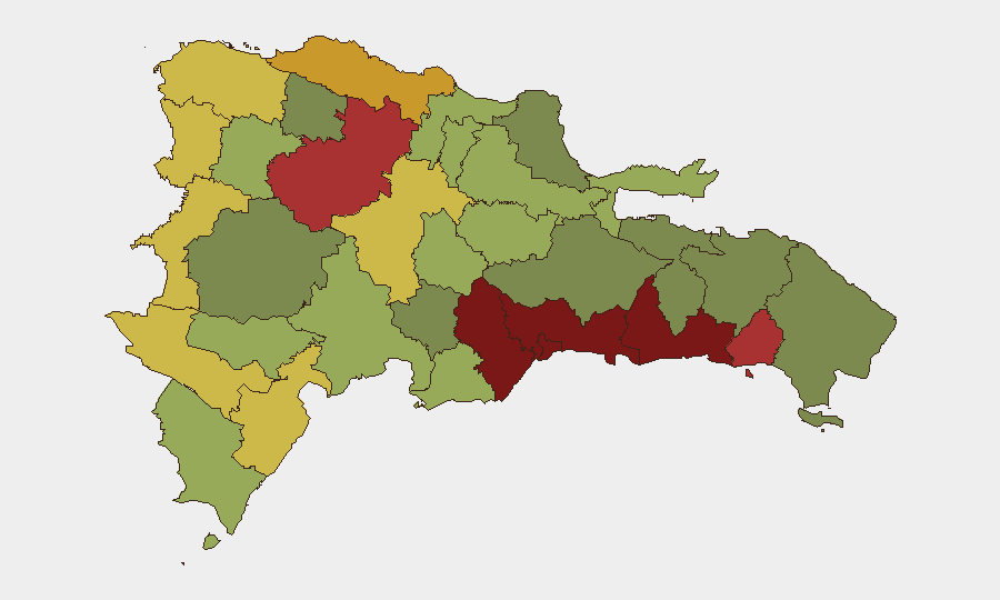
Situation Summary
Dominican Republic remains a moderate-risk jurisdiction (global rank #89, composite score 2) with localized security concerns concentrated in urban centers and border regions. Current threat activity is characterized by routine law-enforcement operations and natural hazards rather than systemic instability. The security environment is stable but fragmented by sub-national variation, with Santo Domingo and Nacional District accounting for the majority of documented risk events.
Key Developments
- 2026-07-08 · Santo Domingo region: GEOBIT platform flagged a disapproval event (COLUMBUS) without additional sourced detail; location and nature require clarification from duty officers on ground.
- 2026-07-07 · Nacional District area: Investigation event (COMMANDER) logged; specific incident type and jurisdiction not specified in current feed.
- 2026-07-08 · Miami-Dominican corridor: Deportation/expulsion event (MIAMI) recorded; consistent with routine immigration and extradition operations between the U.S. and Dominican Republic.
- 2026-07-05 · Southeast of Punta Cana: USGS recorded a magnitude 2.5+ seismic event; no reported casualties or infrastructure damage in available sources, but maritime and tourism-dependent assets in Punta Cana should monitor for aftershock risk.
- Recent (date unconfirmed) · Border waters / Haiti–Dominican Republic maritime route: U.S. Coast Guard interdicted a go-fast vessel carrying approximately 7,800 lbs of garlic from Haiti; indicative of continued trafficking activity along maritime borders, though incident date is not confirmed as within the last 48 hours.
- Recent · Wildfire event (ID 1029053): Dominican Republic experienced a wildfire; specific location, duration, and containment status not available in current summary.
Highest-Risk Areas
Santo Domingo (risk 92) and Nacional District (risk 88) drive the majority of national risk, reflecting urban crime, gang activity, and trafficking networks concentrated in the capital region. San Cristóbal, San Pedro de Macorís, and La Romana (combined risk 83–85) represent secondary urban hotspots with persistent property crime and organized-crime presence. Border provinces—Elías Piña, Dajabón, and Independencia—register elevated risk (64–70) due to Haiti-Dominican Republic cross-border trafficking, irregular migration, and limited state capacity; these areas warrant heightened vigilance for corporate teams with operations or supply-chain exposure in the north and northwest.
How GeoBit Would Assist
Security teams should deploy AOI Monitoring & Early Warning on high-risk provinces (Santo Domingo, Nacional District, San Cristóbal) with persistent alerting on protest, crime, and trafficking signals. Intel Sweep capabilities—combining local news feeds, police/civil-defense channels, and X/Twitter OSINT—enable 24/7 verification of unconfirmed events and rapid clarification of GEOBIT platform signals. Routing & Network Analysis can identify secure alternative transport corridors for personnel and assets bypassing highest-risk urban zones, while Maritime tracking supports monitoring of border-waters trafficking and coast-guard operations that may affect supply-chain timing.
7-Day Outlook
No significant escalation or nationwide instability is forecast over the next seven days. Routine law-enforcement operations, localized crime, and border-trafficking activity will likely persist in current patterns. Natural hazard monitoring (seismic aftershocks near Punta Cana, wildfire containment) should remain active, particularly for tourism and hospitality assets in southeast coastal regions.
Highest-Risk Areas — Ranked
| # | State / Region | Risk |
|---|---|---|
| 1 | Santo Domingo | 92 |
| 2 | Nacional District | 88 |
| 3 | San Cristóbal | 85 |
| 4 | San Pedro de Macorís | 83 |
| 5 | La Romana | 78 |
| 6 | Santiago | 76 |
| 7 | Puerto Plata | 72 |
| 8 | Elías Piña | 70 |
| 9 | Dajabón | 68 |
| 10 | Barahona | 65 |
| 11 | Independencia Province | 64 |
| 12 | La Vega | 62 |
Sources
Previous Daily Briefs
A new Dominican Republic brief is written every day — each with its own risk map and downloadable CSV. Here's the last week; use the calendar to go further back.
📅 Browse every day by calendar →
Highlighted days have a brief. Tap a day for that day's map & analysis, or “csv” for that day's dataset ($5).
Atlas — our AI intelligence desk — emails them this snapshot personally. Nothing else, no list.