Situation Summary
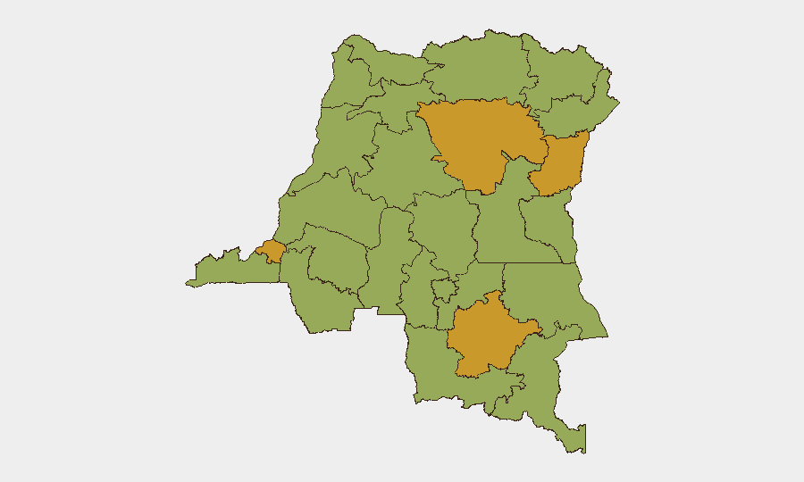
DR Congo remains at composite threat level 65 (global rank #34), with civil conflict as the primary driver and 3,964 tracked events in the analytical window. Four provinces—Tshopo, North Kivu, Kinshasa, and Haut-Lomami—are presently assessed at the highest sub-national risk tier (72.4), reflecting sustained armed group activity, state fragility, and humanitarian pressures. An active Ebola outbreak in Ituri Province adds a secondary health-security layer. The overall trajectory remains volatile with no near-term de-escalation signals.
Key Developments
No discrete security incidents with confirmed timestamps in the 24–48-hour window preceding 16 June 2026 are currently available from verified open-source channels. The most recent time-specific reporting in the analytical set places Ituri Province Ebola figures at 782 confirmed cases and 181 deaths as of 13 June—outside the immediate 48-hour window but current enough to warrant operational awareness. Eight active Ebola treatment centers are reported operating in Ituri, indicating sustained public-health response. Armed group activity in eastern provinces (North Kivu, Tshopo) continues at baseline; no fresh major clashes or displacement events are flagged in the current window. Kinshasa maintains elevated risk from urban crime, gang activity, and civil unrest, though no specific incident is confirmed in the last two days. Border areas (Sud-Ubangi, Nord-Ubangi) show persistent instability linked to regional conflicts, but no cross-border incursion or new displacement has been timestamped in this brief.
Highest-Risk Areas
Tshopo, North Kivu, Kinshasa, and Haut-Lomami form a high-risk corridor driven by overlapping threats: active armed groups (including M23-affiliated forces in the east), weak state control, and sustained humanitarian crises. Kinshasa's elevated risk reflects urban crime and political instability despite capital status. The eastern cluster (Tshopo, North Kivu, Haut-Lomami) remains the epicenter of armed conflict and displacement. Mid-tier provinces (Maniema, Équateur, Nord-Ubangi, Sud-Ubangi) carry secondary risk from spillover violence and cross-border militia activity. Ituri's health emergency does not yet significantly elevate its composite threat ranking but compounds operational constraints for organizations working there.
How GeoBit Would Assist
Teams with personnel or assets in DR Congo should employ AOI Monitoring & Early Warning on Kinshasa, North Kivu, and Tshopo to catch armed group movements or civil unrest in real time. Intel Sweep and multi-language OSINT fusion (X/Twitter, Telegram, local radio SIGINT) provide daily situational updates that fill gaps in mainstream reporting, especially on militia positioning and cross-border activity. Conflict & Military battle mapping and force-structure analysis enable security teams to model M23 and other armed-group disposition and predict safe transit corridors. Routing & Network Analysis supports duty-of-care by identifying alternative supply and evacuation routes when primary roads are compromised.
7-Day Outlook
No major escalation or ceasefire is signaled for the next seven days. Armed group activity in North Kivu and Tshopo will likely remain at current intensity, with continued risk of localized clashes and civilian impact. The Ebola outbreak in Ituri may intensify operational constraints (movement, staff health) but is unlikely to trigger sudden conflict spillover. Urban security concerns in Kinshasa will persist; staff situational awareness and curfew compliance remain essential.
Highest-Risk Areas — Ranked
| # | State / Region | Risk |
|---|---|---|
| 1 | Tshopo | 72.4 |
| 2 | North Kivu | 72.4 |
| 3 | Kinshasa | 72.4 |
| 4 | Haut-Lomami | 72.4 |
| 5 | Maniema | 42.4 |
| 6 | Sud-Ubangi | 42.4 |
| 7 | Équateur | 42.4 |
| 8 | Nord-Ubangi | 42.4 |
| 9 | Mongala | 42.4 |
| 10 | Lower Uele | 42.4 |
| 11 | Tshuapa | 42.4 |
| 12 | Upper Uele | 42.4 |
Sources
Previous Daily Briefs
A new DR Congo brief is written every day — each with its own risk map and downloadable CSV. Here's the last week; use the calendar to go further back.
📅 Browse every day by calendar →
Highlighted days have a brief. Tap a day for that day's map & analysis, or “csv” for that day's dataset ($5).