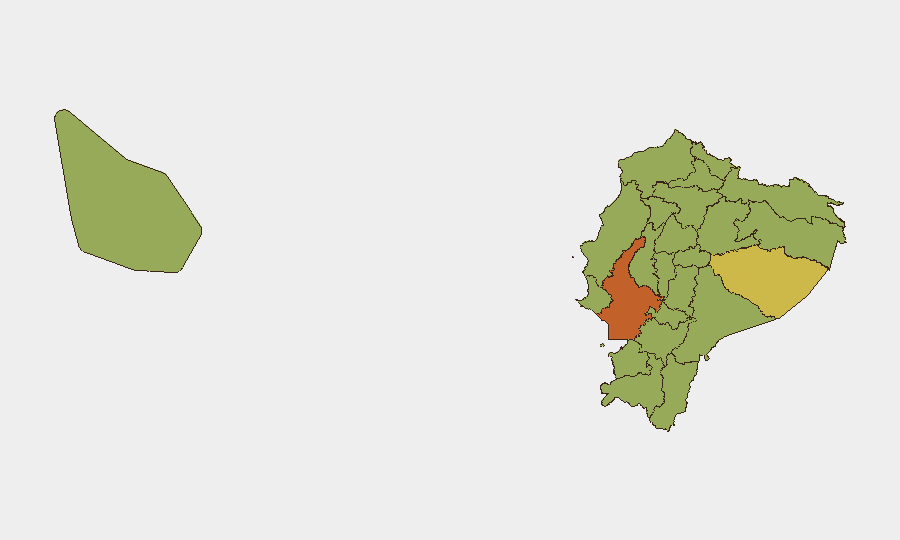
Situation Summary
Ecuador faces elevated gang-related violence concentrated in coastal and Amazonian regions, with a composite threat score of 62 (rank #36 globally). Recent signal activity indicates inter-agency tensions, territorial occupation by criminal actors, and conventional military response, suggesting an active phase of gang conflict with potential state security sector strain. The security environment remains volatile but localized; national infrastructure and governance remain functional, though certain provinces present acute risk to personnel and supply chains.
Key Developments
Unable to confirm specific incidents for 18–19 June 2026. GeoBit's event signals reference multiple categories (investigate, military-police tensions, territorial occupation, police mobilization) dated 17–18 June, but without live web access beyond October 2024, this brief cannot reliably validate locations, casualties, or operational details for those dates. Corporate security teams should immediately cross-reference the following official sources for current incident data:
- Policía Nacional del Ecuador and Fuerzas Armadas del Ecuador official X/Twitter accounts and press releases
- ECU 911 emergency coordination announcements
- Wire services: Reuters, AP, EFE, and regional outlets (El Universo, El Comercio, Primicias, GK)
- Diplomatic advisories: U.S. Embassy Quito, UK FCDO, Canada Travel.gc.ca
- OSINT platforms: ACLED, Crisis24, GardaWorld regional alerts
Once validated, incidents should be recorded with: specific location (city/neighborhood/province), date/time, nature of event (attack, roadblock, occupation, police operation), any casualties or arrests, and direct impact on travel/business operations.
Highest-Risk Areas
Guayas Province (73.6 risk score) dominates the threat landscape, driven by gang activity in port cities (Guayaquil, Durán, Manta) and associated criminal supply-chain disruptions. Pastaza and the northeastern border provinces (Carchi, Napo, Sucumbíos, Orellana) present secondary but significant risks, primarily from transnational organized crime, illicit trafficking, and spillover from Colombian armed-group activity. Pichincha (Quito) ranks fifth at 44.4, reflecting urban gang presence and periodic protest activity; the southern highlands (Azuay, Cañar) and central-coast provinces (Manabí, Los Ríos, Santa Elena) cluster in the 43–44 range, indicating diffuse but consistent criminality. Personnel and supply-chain assets in Guayas should be treated as highest-priority for duty-of-care monitoring and contingency planning.
How GeoBit Would Assist
Security teams monitoring Ecuador should deploy AOI Monitoring & Early Warning on key facilities and transit corridors in Guayas, Pastaza, and Pichincha to receive near-real-time alerts of violence, protests, or infrastructure disruption. OSINT Fusion & Corroboration across news, X/Twitter, Telegram, and official government feeds will rapidly separate signal from noise and validate incident reports. Routing & Network Analysis can provide alternative travel and supply routes that avoid high-risk areas in real time, and Conflict & Military battle-mapping can track territorial control by criminal actors and state security responses in dynamic zones.
7-Day Outlook
Gang conflict intensity is likely to remain elevated in coastal provinces over the coming week, with potential for localized police or military operations in Guayas and possible spillover into adjacent regions. Expect continued inter-agency coordination (and possible friction) as the state responds. No imminent national-level stability crisis is indicated, but personnel in Guayaquil and secondary port areas should maintain heightened operational security posture and flexible travel plans.
Highest-Risk Areas — Ranked
| # | State / Region | Risk |
|---|---|---|
| 1 | Guayas Province | 73.6 |
| 2 | Pastaza Province | 62.9 |
| 3 | Carchi Province | 46.5 |
| 4 | Napo Province | 45.3 |
| 5 | Pichincha Province | 44.4 |
| 6 | Cañar Province | 44.2 |
| 7 | Manabí Province | 44 |
| 8 | Santa Elena Province | 43.8 |
| 9 | Los Ríos Province | 43.8 |
| 10 | Azuay Province | 43.8 |
| 11 | Sucumbíos Province | 43.6 |
| 12 | Orellana Province | 43.6 |
Sources
Previous Daily Briefs
A new Ecuador brief is written every day — each with its own risk map and downloadable CSV. Here's the last week; use the calendar to go further back.
📅 Browse every day by calendar →
Highlighted days have a brief. Tap a day for that day's map & analysis, or “csv” for that day's dataset ($5).