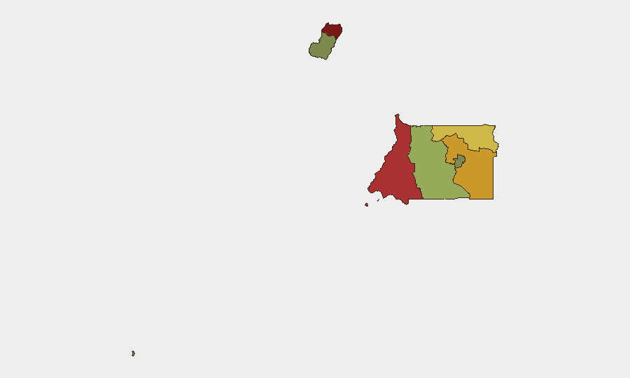
Situation Summary
Equatorial Guinea presents a composite threat level assessed at 3 (global rank: unranked), with no discrete security events tracked in the current reporting window. However, underlying risk drivers—including deteriorated urban crime in major population centers, prolonged telecommunications disruption, and epidemiological entry screening—remain operationally relevant for corporate personnel and asset security. The security posture is characterized by persistent rather than acute risk; trajectory is stable absent new triggering events.
Key Developments
- Telecommunications disruption (Countrywide, 14–21 July 2026): Prolonged BGP routing outage affecting national internet connectivity visibility, with disruption ongoing as of 21 July. Impact on corporate communications, data transfer, and remote-work resilience remains unresolved.
- Epidemiological entry screening (Countrywide, 18 July 2026): Equatorial Guinea imposed mandatory 21-day quarantine on arrivals from Ebola-affected regions in Uganda and the Democratic Republic of the Congo, effective mid-July. Relevant for personnel movement planning and medical contingency.
- Crime advisory escalation (Malabo, Bata, ongoing through 25 July 2026): Spanish government travel advisory confirms worsening crime trend, specifically increased robberies, assaults, and nighttime attacks in leisure districts. Night-time taxi use flagged as high-risk.
- Land border closure (Continental borders, 15 December 2025–present): Equatorial Guinea's overland borders remain closed for indefinite period; air and sea ports remain operational under caution advisories.
- Annobón travel restriction (Annobón Province, ongoing): Tourist visits not recommended; implications for any personnel deployed to the island require case-by-case assessment.
Highest-Risk Areas
Bioko Norte (risk 85) and Litoral Province (risk 78) drive the country's sub-national risk profile. Both regions encompass major urban centers (Malabo and Bata respectively) where crime dynamics—robbery, assault, and predatory nighttime activity—concentrate personnel exposure. Wele-Nzas (72) and Kié-Ntem (68) provinces, located along closed land borders, carry secondary risk from border-area instability and restricted movement corridors. Remaining provinces (Centro Sur, Bioko Sur, Djibloho, Annobón) present materially lower composite risk, though Annobón remains under formal travel restriction.
How GeoBit Would Assist
Corporate security teams would deploy Intel Sweep and multi-language OSINT to monitor Malabo and Bata crime trends in real time, supported by X/Twitter and Telegram OSINT for incident corroboration and emerging threats. AOI Monitoring & Early Warning with persistent watch on high-risk leisure districts and port facilities would provide automated alerting for personnel in situ. Routing & Network Analysis capabilities enable security teams to pre-plan alternative journey corridors and transportation modes (air vs. ground) to mitigate night-movement and taxi-related exposure.
7-Day Outlook
No acute security escalation is forecast over the next seven days absent new triggering events. The telecommunications outage trajectory remains unclear; if unresolved beyond 48–72 hours, contingency communication protocols should activate. Crime levels in Malabo and Bata are expected to remain elevated; personnel movement during daylight hours and use of vetted transport remain primary mitigations.
Highest-Risk Areas — Ranked
| # | State / Region | Risk |
|---|---|---|
| 1 | Bioko Norte | 85 |
| 2 | Litoral Province | 78 |
| 3 | Wele-Nzas Province | 72 |
| 4 | Kié-Ntem Province | 68 |
| 5 | Centro Sur Province | 45 |
| 6 | Bioko Sur | 38 |
| 7 | Djibloho | 15 |
| 8 | Annobón Province | 8 |
Sources
Previous Daily Briefs
A new Equatorial Guinea brief is written every day — each with its own risk map and downloadable CSV. Here's the last week; use the calendar to go further back.
📅 Browse every day by calendar →
Highlighted days have a brief. Tap a day for that day's map & analysis, or “csv” for that day's dataset ($5).
Atlas — our AI intelligence desk — emails them this snapshot personally. Nothing else, no list.