Situation Summary
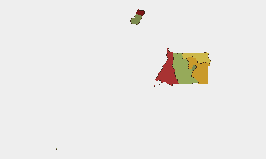
Equatorial Guinea remains a low-incident, structurally elevated-risk environment characterized by chronic urban crime (robberies, assaults) in major centers rather than acute conflict or political instability. No discrete security events have been confirmed in the last 24–48 hours. The country's overall threat trajectory is stable but fragmented by sub-national variance, with northern and coastal regions (Bioko Norte, Litoral) carrying significantly higher risk profiles than interior and island areas.
Key Developments
No verifiable security, conflict, civil-unrest, or infrastructure incidents meeting intelligence-grade standards (specific time, place, multi-source confirmation) have been identified in Equatorial Guinea during 25–27 July 2026.
Context: A national internet connectivity disruption that began 14 July 2026 and persisted through approximately 21 July 2026 has been resolved; no follow-up infrastructure incidents are reported as of 26 July. Spanish MFA advisories note deterioration in urban security conditions (robberies, aggressions) in Malabo and Bata over preceding months, but these represent chronic patterns, not dated incidents in the current window. Continental land borders remain closed since 15 December 2025; a 21-day Ebola-related quarantine for arrivals from Uganda and DRC entered force 18 July 2026—both policy measures, not events.
Highest-Risk Areas
Bioko Norte (risk 85) and Litoral Province (risk 78) dominate the sub-national threat landscape, driven by concentrated urban populations in Malabo and Bata where robbery, street crime, and assault prevalence is highest. Wele-Nzas and Kié-Ntem provinces (scores 72 and 68, respectively) sustain elevated risk, likely reflecting border dynamics, limited state presence, and trafficking activity along the Cameroon and Gabon boundaries. By contrast, Annobón Province (risk 8) and Djibloho (risk 15) present minimal reported threat surfaces, correlating with low population density and administrative remoteness. Risk concentration in the northwest and north-central regions should be the primary focus for duty-of-care and asset-protection planning.
How GeoBit Would Assist
A security team with personnel or assets in Equatorial Guinea would employ AOI Monitoring & Early Warning to establish persistent, automated watch over Malabo, Bata, and border crossings (Wele-Nzas, Kié-Ntem), configured to flag changes in crime reporting, crowd activity, or security-force movements. Intel Sweep and X/Twitter & Telegram OSINT capabilities enable continuous, multi-language monitoring of local and diaspora open sources to detect emerging incidents, unrest signals, or infrastructure disruptions before they escalate. Risk & Threat Assessment and Routing & Network Analysis would support contingency planning—alternative travel routes within the country, safe-haven identification, and real-time journey advisories for high-risk urban areas.
7-Day Outlook
No acute trigger for deterioration is evident in the current data window. Urban crime and border-control patterns are likely to remain stable through early August, absent exogenous shocks (regional conflict spillover, political friction, or health emergencies). Continued passive monitoring of Bioko Norte and Litoral via open-source and OSINT channels is prudent for early warning of any shift in baseline conditions.
Highest-Risk Areas — Ranked
| # | State / Region | Risk |
|---|---|---|
| 1 | Bioko Norte | 85 |
| 2 | Litoral Province | 78 |
| 3 | Wele-Nzas Province | 72 |
| 4 | Kié-Ntem Province | 68 |
| 5 | Centro Sur Province | 45 |
| 6 | Bioko Sur | 38 |
| 7 | Djibloho | 15 |
| 8 | Annobón Province | 8 |
Sources
Previous Daily Briefs
A new Equatorial Guinea brief is written every day — each with its own risk map and downloadable CSV. Here's the last week; use the calendar to go further back.
📅 Browse every day by calendar →
Highlighted days have a brief. Tap a day for that day's map & analysis, or “csv” for that day's dataset ($5).
Atlas — our AI intelligence desk — emails them this snapshot personally. Nothing else, no list.