Situation Summary
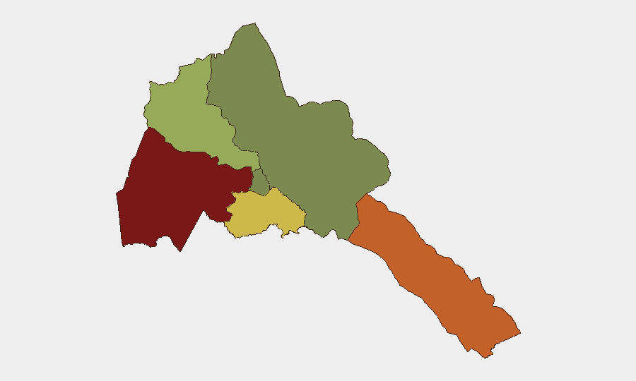
Eritrea remains a low-frequency event environment with minimal discrete security incidents in the current tracking window. The country's composite threat score (10) reflects structural constraints—limited open reporting, restricted media access, and a heavily state-controlled information environment—rather than absence of underlying risk. Diplomatic engagement with Sudan and regional Red Sea security consultations suggest active Horn of Africa positioning, but no imminent destabilizing developments are evident. Risk concentration remains geographic: border regions and the southern periphery carry substantially elevated threat profiles, while the capital region (Maekel) shows markedly lower exposure.
Key Developments
- Asmara, 17 July 2026: President Isaias Afwerki held bilateral consultations with Sudan's sovereign-council chairman Abdel Fattah al-Burhan to discuss bilateral relations and Sudan-specific developments, signaling continued diplomatic coordination in a region marked by ongoing instability in neighboring Sudan.
- Cairo (regional), 19 July 2026: Egypt and Eritrea jointly issued a statement rejecting non-littoral participation in Red Sea security arrangements, reaffirming that coastal-state primacy should govern maritime governance in the region—a position aligned with Eritrea's strategic interests as a Red Sea littoral power.
- Cairo (regional), 21 July 2026: Eritrea participated in diplomatic consultations involving Egypt, Somalia, and a senior U.S. envoy focused on Horn of Africa and Red Sea security architecture, indicating ongoing multilateral engagement on regional stability and maritime issues.
Highest-Risk Areas
Gash-Barka (92) and the Southern Red Sea Region (75) drive the country's threat profile, with Debub Region (68) also materially elevated. Gash-Barka's proximity to Sudan—a country experiencing active conflict and state fragmentation since April 2023—creates cross-border volatility risk including irregular migration, weapons proliferation, and potential spillover. The Southern Red Sea Region's score reflects maritime exposure, including piracy risk corridors, smuggling networks, and disputed maritime boundaries. Maekel Region (18), which includes Asmara, shows substantially lower composite risk, reflecting greater state control and reduced criminality in the capital zone. Northern Red Sea Region (0) remains minimally exposed in available intelligence.
How GeoBit Would Assist
For teams with personnel or assets in Eritrea, Area-of-Interest Monitoring & Early Warning paired with Border & Disputed Territory Search would provide persistent watch on Gash-Barka and cross-border Sudan dynamics, flagging irregular activity, armed-group movement, or checkpoint disruptions before operational impact. Network & Actor Analysis combined with OSINT fusion (X/Twitter, Telegram, multi-language sources) would track diplomatic and regime-stability signals, enabling early detection of policy shifts, conscription expansion, or internal repression escalation affecting workforce or travel corridors. Maritime & Aviation Tracking would monitor Red Sea shipping lanes and port activity, supporting supply-chain continuity and staff movement planning in the Southern Red Sea Region.
7-Day Outlook
No significant security deterioration is anticipated in the immediate term. Diplomatic engagement with Sudan and Egypt suggests Eritrea's current focus is regional positioning rather than internal escalation. Border volatility remains chronic but not acute; watch for any Sudan-related refugee flows or weapons movements into Gash-Barka, which could signal a shift. Continue baseline monitoring of conscription activity and transport checkpoints in high-risk regions.
Highest-Risk Areas — Ranked
| # | State / Region | Risk |
|---|---|---|
| 1 | Gash-Barka | 92 |
| 2 | Southern Red Sea Region | 75 |
| 3 | Debub Region | 68 |
| 4 | Anseba | 55 |
| 5 | Maekel Region | 18 |
| 6 | Northen Red Sea Region | 0 |
Sources
Previous Daily Briefs
A new Eritrea brief is written every day — each with its own risk map and downloadable CSV. Here's the last week; use the calendar to go further back.
📅 Browse every day by calendar →
Highlighted days have a brief. Tap a day for that day's map & analysis, or “csv” for that day's dataset ($5).
Atlas — our AI intelligence desk — emails them this snapshot personally. Nothing else, no list.