Situation Summary
Guinea-Bissau remains stable at the national level, with no verified security incidents or civil unrest reported in the last 24–48 hours. Routine ECOWAS peacekeeping rotations are proceeding normally in Bissau. Risk is concentrated in the northern and eastern regions—particularly Gabu, Oio, and Bafatá—where structural instability and cross-border dynamics maintain elevated threat profiles; the capital and southern regions show lower acute risk. The security environment is quiescent but fragile, with persistent sub-national vulnerabilities requiring sustained monitoring.
Key Developments
- Routine military rotation, Bissau, 3 August 2026: Nigerian forces completed a standard troop handover for the ECOWAS Stabilisation Support Mission; this is normal operational activity, not a security incident.
- No verified border disruptions, Senegal frontier, last 48 hours: monitoring of the São Domingos/Mpack crossing area found no closed crossings, clashes, or travel restrictions.
- No confirmed civil or political instability, nationwide, last 48 hours: open-source monitoring identified zero dated, verifiable reports of armed conflict, unrest, arrest, or government disruption.
- Unconfirmed social-media claims excluded: circulation of undated X/social posts referencing military action and "security tightening" lack independent corroboration and timestamp; excluded from this assessment per reporting standards.
Highest-Risk Areas
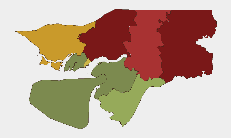
Gabu Region (risk 92) and Oio Region (risk 85) dominate the threat landscape, followed by Bafatá (78). These northern and eastern zones reflect a combination of porous borders, limited state capacity, and transnational dynamics (trafficking, irregular migration, spillover from regional instability). Cacheu Region (72) and the Bissau Autonomous Sector (68) present secondary but significant risk. Southern regions (Tombali, Quinara, Biombo, Bolama) show markedly lower composite scores, reflecting stronger governance presence and isolation from cross-border pressure points. Risk concentration in the north and east underscores the importance of border-area and sub-national monitoring for corporate and NGO operations.
How GeoBit Would Assist
Security teams should deploy AOI Monitoring & Early Warning on Gabu, Oio, and Bafatá regions with hourly alert thresholds to capture cross-border movement, military activity, or civil unrest at earliest emergence. Intel Sweep and OSINT fusion (X/Telegram, local news wires, radio SIGINT) will ensure that unconfirmed social claims are rapidly corroborated or dismissed before they affect duty-of-care decisions. GIS & Spatial Analysis and alternative routing planning enable security teams to map safe corridors for personnel and asset movement, avoiding high-risk zones identified in the sub-national ranking. These capabilities allow real-time situational awareness without reliance on outdated or unverified reporting.
7-Day Outlook
No imminent security escalation is forecast for the coming week. ECOWAS peacekeeping operations are expected to continue routine cycles. Underlying structural risks in the north will persist, but acute incident probability remains low absent new triggering events (border clashes, political upheaval, or major trafficking incidents). Corporate and NGO operations in Bissau and southern regions should continue standard protocols; northern regional operations warrant elevated vigilance and frequent check-ins with GeoBit monitoring feeds.
BRIEFING METADATA
*Date:* 2026-08-05 | *Scope:* Guinea-Bissau, nationwide + sub-national | *Confidence:* Medium (low event volume, data gaps in remote areas) | *Next scheduled update:* 2026-08-06
Highest-Risk Areas — Ranked
| # | State / Region | Risk |
|---|---|---|
| 1 | Gabu Region | 92 |
| 2 | Oio Region | 85 |
| 3 | Bafatá Region | 78 |
| 4 | Cacheu Region | 72 |
| 5 | Bissau Autonomous Sector | 68 |
| 6 | Tombali Region | 45 |
| 7 | Quinara Region | 38 |
| 8 | Biombo Region | 32 |
| 9 | Bolama Region | 15 |
Sources
Previous Daily Briefs
A new Guinea-Bissau brief is written every day — each with its own risk map and downloadable CSV. Here's the last week; use the calendar to go further back.
📅 Browse every day by calendar →
Highlighted days have a brief. Tap a day for that day's map & analysis, or “csv” for that day's dataset ($5).
Atlas — our AI intelligence desk — emails them this snapshot personally. Nothing else, no list.