Situation Summary
Guyana's overall threat environment remains elevated but static, with a composite threat score of 14 and no major incident clusters emerging in the past 48 hours. Urban crime—particularly armed robbery, firearm trafficking, and gang-related activity—continues to dominate the security landscape, concentrated in Georgetown and its coastal corridors. The volatile border situation with Venezuela, especially in the Essequibo region, remains a secondary but persistent concern for organizations with assets in the interior or western regions.
Key Developments
- No clearly time-stamped security or crime incidents with verifiable recency (Aug 2–4, 2026) are currently visible in accessible open-source feeds, major news outlets, or social media streams. Baseline risks (urban armed crime, firearm possession, border volatility) remain operationally current but are not being driven by acute incident activity in the immediate 48-hour window.
- Late July 2026 (reported Aug 1): Campbellville, Georgetown—Police are actively seeking two motorcycle-riding suspects responsible for a series of purse-snatching attacks, with at least one victim injured; heightened local crime concern in this residential area near the city center.
- Late July 2026 (late-week activity): Georgetown (Independence Boulevard and Mandela Avenue)—Police arrested three men in separate operations; a Sig Sauer 9mm pistol with 19 live rounds was seized at a bar on Independence Boulevard, and .223 ammunition plus a spent shell were recovered from a Hilux on Mandela Avenue. All three remain in custody pending charges.
- Ongoing: Canada's travel advisory remains in effect, recommending a high degree of caution due to high urban crime rates and emphasizing a volatile security environment along the Venezuela border, particularly in the Essequibo region.
Highest-Risk Areas
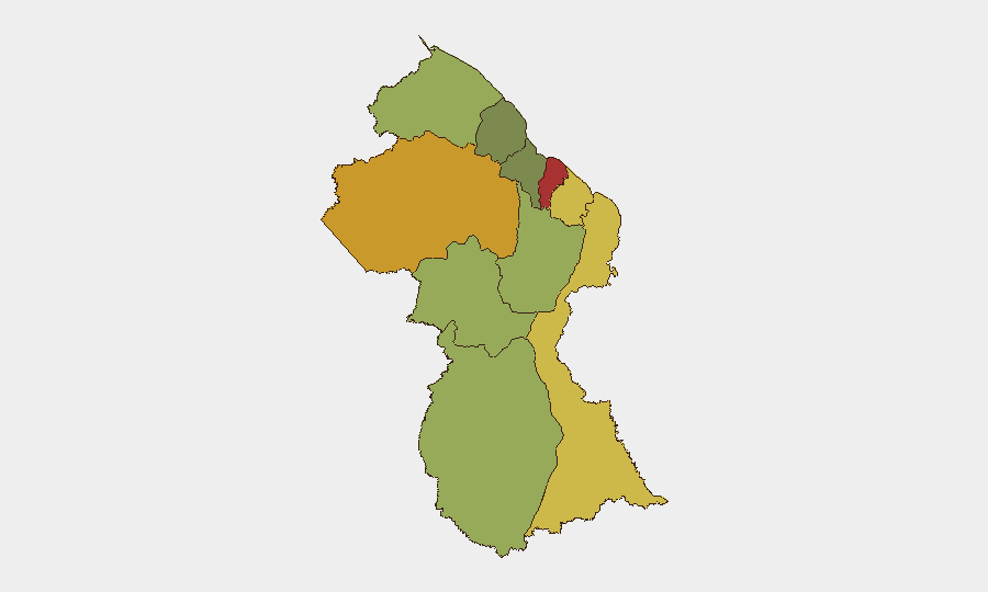
Demerara-Mahaica (risk 78) and Cuyuni-Mazaruni (risk 72) drive the majority of tracked threat activity. Demerara-Mahaica encompasses Georgetown and its immediate surroundings, where armed robbery, firearm trafficking, and gang violence remain concentrated; Cuyuni-Mazaruni, spanning the interior west and the Venezuelan border zone, faces compounded risk from both transnational smuggling networks and border instability. The top five regions (Demerara-Mahaica through Upper Demerara-Berbice) account for the bulk of national risk, with coastal urban areas significantly outweighing interior and island regions.
How GeoBit Would Assist
Security teams with people or assets in Guyana should employ AOI (Area-of-Interest) Monitoring & Early Warning to track the highest-risk coastal corridors—particularly Demerara-Mahaica—for emerging crime clusters or incident patterns that may not yet be visible in mainstream reporting. Intel Sweep and X/Twitter/Telegram OSINT capabilities enable near-real-time detection of gang activity, firearm trafficking networks, and border-related developments before official press cycles. GIS & Spatial Analysis and alternative route planning help duty-of-care teams optimize safe movement for personnel in Georgetown and plan avoidance of high-crime zones during operations.
7-Day Outlook
No major escalation is forecast for the immediate week; however, persistent ambient crime pressure in Georgetown and coastal regions will continue to pose operational friction for organizations with staff or assets on the ground. The border situation should be monitored continuously, as any uptick in Venezuelan activity or Essequibo tensions could rapidly elevate interior and western region risk profiles. Routine security protocols (curfew compliance, area avoidance, armed escort where warranted) remain the operational baseline.
Highest-Risk Areas — Ranked
| # | State / Region | Risk |
|---|---|---|
| 1 | Demerara-Mahaica | 78 |
| 2 | Cuyuni-Mazaruni | 72 |
| 3 | Mahaica-Berbice | 65 |
| 4 | East Berbice-Corentyne | 62 |
| 5 | Upper Demerara-Berbice | 58 |
| 6 | Potaro-Siparuni | 48 |
| 7 | Barima-Waini | 45 |
| 8 | Upper Takutu-Upper Essequibo | 42 |
| 9 | Pomeroon-Supenaam | 38 |
| 10 | Essequibo Islands | 35 |
Sources
Previous Daily Briefs
A new Guyana brief is written every day — each with its own risk map and downloadable CSV. Here's the last week; use the calendar to go further back.
📅 Browse every day by calendar →
Highlighted days have a brief. Tap a day for that day's map & analysis, or “csv” for that day's dataset ($5).
Atlas — our AI intelligence desk — emails them this snapshot personally. Nothing else, no list.