Situation Summary
Iraq faces a sharp, near-term escalation in kinetic activity and militia-coordinated strikes across multiple provinces, driven by intensifying U.S.–Iran proxy tensions and domestic assassination plots against state officials. The past 48 hours have seen a marked spike in small-arms combat, aerial weapons use, drone attacks on infrastructure and opposition camps, and security-force casualties concentrated in Al-Anbar, Kirkuk, and the Kurdistan Region. Diplomatic engagement between Baghdad and Erbil is elevated but reactive; the security environment is assessed as "markedly deteriorated" through at least mid-week, with commercial aviation resuming under ongoing missile and drone threat.
Key Developments
- Al-Anbar Governorate (June 14–15): Sharp spike in militia activity, weapons trafficking, and small-arms clashes with concurrent aerial weapons use; primary locus of violence in past 48 hours, significantly elevating travel risk on key routes.
- Kirkuk Governorate (June 15): Airstrike near Kirkuk killed three Popular Mobilization Forces fighters and two Iraqi police officers; incident linked to broader U.S.–Iran escalation and new force-protection postures in northern Iraq.
- Erbil / Qushtapa district (June 15): Two explosive-laden drones struck vital civilian infrastructure in Qushtapa, south of Erbil, causing extensive damage but no reported casualties; described as "terrorist operation" with no claim of responsibility. Separately, National Security Adviser Qasim al-Araji traveled to Erbil to investigate over 20 recent drone attacks in Kurdistan Region, including strikes on Iranian opposition camps east of Erbil.
- Baghdad (June 14–15): National Security Service arrested 15 individuals across multiple locations for allegedly plotting assassinations of senior security officials; broader uptick in targeted-killing activity and elevated risk to officials in and around the capital.
- U.S. Embassy, Baghdad (June 15–16): New security alert posted warning that Iran-aligned militias continue planning attacks against U.S. citizens and U.S.-associated targets throughout Iraq, including Kurdistan Region; ongoing risks from missiles, drones, and projectiles in Iraqi airspace as limited commercial flights resume.
- Baghdad–Erbil corridor (June 14–15): Intensified high-level diplomatic traffic including meetings between Kurdistan Region Prime Minister and foreign ambassadors, focused on managing cross-border tensions, drone threats, and militia activity; signals short-term concern over political stability and conflict spillover along key transport and energy corridors.
Highest-Risk Areas
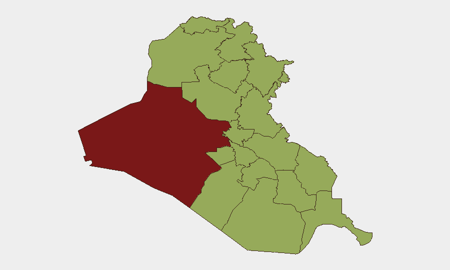
Al-Anbar Governorate (risk 81.7) dominates the threat picture, driven by sustained militia operations, weapons trafficking, and active small-arms and aerial combat in the past 48 hours. The remaining 11 tracked governorates cluster at risk 51.7–52.2, reflecting nationwide distribution of kinetic activity, assassination plots, drone strikes, and militia presence—particularly acute in Kirkuk and the Erbil area of Kurdistan Region. The concentration of U.S. diplomatic warnings, security-force casualties, and targeting of civilian infrastructure indicates that militia coordination and cross-border drone operations are now the primary drivers of elevated risk across northern and western Iraq.
How GeoBit Would Assist
Teams should deploy AOI Monitoring & Early Warning on Al-Anbar, Kirkuk, and Erbil/Qushtapa to track drone and militia activity in real time. Intel Sweep and OSINT fusion (X/Twitter, Telegram, open-source conflict reporting) will corroborate emerging militia claims, drone-attack patterns, and U.S.–Iran signaling. Routing & Network Analysis and GIS & Spatial Analysis enable duty-of-care teams to plan safer movement corridors around identified hot spots and identify safe-haven nodes for personnel.
7-Day Outlook
Kinetic activity and drone operations are expected to remain elevated through at least June 20, with particular risk concentrated in Al-Anbar, Kirkuk, and Kurdistan Region. Diplomatic engagement between Baghdad and Erbil may stabilize political tensions but is unlikely to curtail militia or Iranian drone operations in the near term. Commercial aviation remains under advisory; non-essential movement in western and northern Iraq should be treated as high-risk.
Highest-Risk Areas — Ranked
| # | State / Region | Risk |
|---|---|---|
| 1 | Al-Anbar Governorate | 81.7 |
| 2 | Al-Muthanna Governorate | 52.2 |
| 3 | Babil Governorate | 51.7 |
| 4 | Wasit Governorate | 51.7 |
| 5 | Al-Qadisiyah Governorate | 51.7 |
| 6 | Dhi Qar Governorate | 51.7 |
| 7 | Maysan Governorate | 51.7 |
| 8 | Al-Basra Governorate | 51.7 |
| 9 | Al-Najaf Governorate | 51.7 |
| 10 | Saladin Governorate | 51.7 |
| 11 | Erbil Governorate | 51.7 |
| 12 | Kirkuk Governorate | 51.7 |
Sources
Previous Daily Briefs
A new Iraq brief is written every day — each with its own risk map and downloadable CSV. Here's the last week; use the calendar to go further back.
📅 Browse every day by calendar →
Highlighted days have a brief. Tap a day for that day's map & analysis, or “csv” for that day's dataset ($5).