Situation Summary
Ivory Coast remains a stable mid-tier risk environment globally (#52 composite threat score) with no confirmed major security incidents in the last 24–48 hours. The country's overall security posture is characterized by persistent subnational vulnerabilities concentrated in the northern and western districts rather than acute, active conflict or widespread civil unrest. Open-source monitoring shows no verifiable armed clashes, significant criminal events, infrastructure failures, or travel-emergency conditions as of 11 July 2026.
Key Developments
No discrete security, conflict, civil-unrest, crime, political-instability, infrastructure, or acute travel-risk incidents meeting verification thresholds have been reported from Ivory Coast in the 24–48 hour window (9–11 July 2026) in monitored open-source feeds, X/Twitter, major news agencies, or regional OSINT channels.
Available open-source coverage for this period is sparse and dominated by non-security content (World Cup sports reporting). The absence of reported incidents does not indicate zero risk, but rather the current absence of acute triggering events or major escalations within the standard reporting window.
Highest-Risk Areas
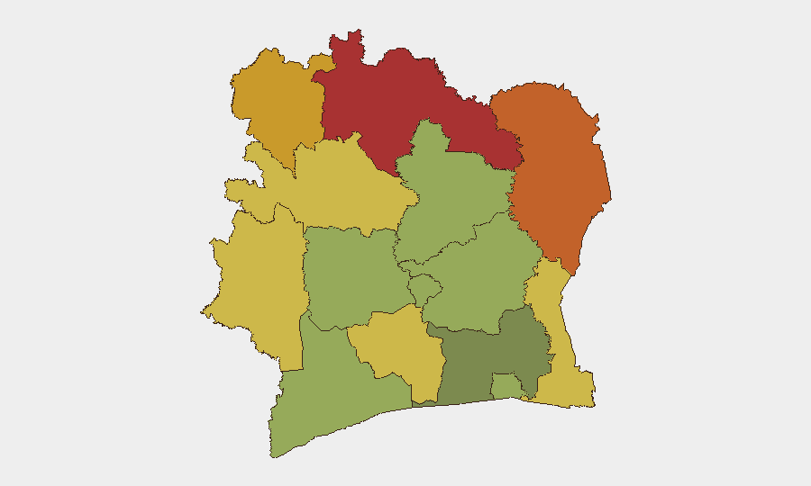
Northern districts—Savanes, Zanzan, and Denguélé (risk scores 78, 75, 72 respectively)—drive the country's composite threat profile. These regions face persistent vulnerabilities including limited state presence, cross-border movement with Mali and Burkina Faso, and historical exposure to transnational criminal and militant activity. Comoé and Montagnes districts (70, 68) present secondary elevated risk. By contrast, Abidjan and surrounding coastal districts carry lower relative risk scores (45–52), reflecting stronger institutional presence and urban security infrastructure. Northern risk does not equate to current active crisis but reflects structural fragility and geographic proximity to regional conflict zones.
How GeoBit Would Assist
Security and duty-of-care teams with personnel or assets in Ivory Coast should employ AOI (Area-of-Interest) Monitoring & Early Warning on high-risk districts—particularly Savanes and Zanzan—configured to alert on armed activity, political signaling, and unusual cross-border movement. Multi-language OSINT (X/Twitter, Telegram, regional radio SIGINT) provides real-time signal detection of emerging unrest or criminal incidents missed by English-language news. GIS & Spatial Analysis combined with Routing & Network Analysis enables rapid alternative-route planning for personnel mobility if localized incidents do materialize, ensuring teams can pivot without delay.
7-Day Outlook
No acute escalation is forecasted for the next 7 days based on current open-source signals and subnational risk profiles. Monitoring posture should remain standard: persistent watch on northern districts, routine OSINT sweeps, and standing alternative-route protocols for mobile teams. The risk environment is likely to remain stable unless external factors (Mali/Burkina Faso spillover, political calendar events, or criminal activity) trigger identifiable signals.
Highest-Risk Areas — Ranked
| # | State / Region | Risk |
|---|---|---|
| 1 | Savanes District | 78 |
| 2 | Zanzan District | 75 |
| 3 | Denguélé District | 72 |
| 4 | Comoé District | 70 |
| 5 | Montagnes District | 68 |
| 6 | Woroba District | 65 |
| 7 | Gôh-Djiboua District | 60 |
| 8 | Sassandra-Marahoué District | 58 |
| 9 | Vallée du Bandama District | 55 |
| 10 | Bas-Sassandra District | 52 |
| 11 | Lacs District | 48 |
| 12 | Abidjan | 45 |
Sources
Previous Daily Briefs
A new Ivory Coast brief is written every day — each with its own risk map and downloadable CSV. Here's the last week; use the calendar to go further back.
📅 Browse every day by calendar →
Highlighted days have a brief. Tap a day for that day's map & analysis, or “csv” for that day's dataset ($5).
Atlas — our AI intelligence desk — emails them this snapshot personally. Nothing else, no list.