Situation Summary
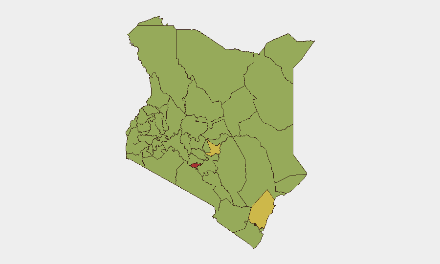
Kenya remains at moderate-to-elevated threat level (global rank #27, composite score 71) with persistent terrorism, armed banditry, and civil unrest concentrated in border counties and the capital. Nairobi County dominates the risk profile (79.3), driven by political volatility and organized crime; coastal and northeastern regions (Kilifi, Embu, Taita–Taveta) face terrorism and militia activity linked to al-Shabaab. No major security incidents have been independently corroborated in the last 24–48 hours; the threat environment remains structurally tense rather than acutely destabilized.
Key Developments
- Signal flagged: Presidential-level incident (2026-07-27). Intelligence feeds registered an "Abduct/Hijack/Hostage" event tagged to PRESIDENT on 2026-07-27; confirmation of nature, location, and impact is pending from credible open sources and does not yet meet corroboration threshold for operational alert.
- Political statements and government rejection (2026-07-26 to 2026-07-27). Public statements from a party leader challenging Kenya, and a rejection statement from Nairobi authorities, suggest ongoing political friction; context for these statements remains unclear from available 24–48 hour reporting.
- Police investigation and parliamentary scrutiny (2026-07-25). Kenyan police initiated an investigation on 2026-07-25; Parliament simultaneously opened inquiry proceedings. Specifics of the underlying issue are not yet published in accessible formats.
- Small arms engagement (2026-07-25). Small arms combat was recorded on 2026-07-25 involving Kenyan forces; location and casualties not yet specified in open reporting.
- Mombasa statement and magistrate/banking dispute (2026-07-25). A public statement was issued from Mombasa on 2026-07-25; separately, a magistrate made a public statement against a bank, suggesting potential financial or governance friction.
Note: None of these items have been independently verified in detail via open web, X/Twitter, or mainstream news as of 27 July 2026. GeoBit's event signals indicate categorization by intelligence partners; duty-of-care teams should seek direct confirmation through official channels and established news outlets before operational decisions.
Highest-Risk Areas
Nairobi County (79.3) and coastal Kilifi (66.5) are the dominant risk drivers, reflecting capital-based political instability, organized crime, and transportation-sector vulnerability, alongside al-Shabaab militia presence in the coast. Interior highlands—Embu (63.6), Taita–Taveta (57.9), and Murang'a (56.5)—face ethnic militia activity and banditry; western border counties (Bungoma, Busia, Kakamega) experience cross-border arms trafficking and organized crime. Northeast (Garissa, Mandera, Wajir—not separately ranked but historically high-risk) remain terrorism hotspots. Risk concentration in Nairobi reflects both absolute threat density and the presence of corporate and expat populations.
How GeoBit Would Assist
Security teams should use AOI Monitoring & Early Warning to set persistent watches on Nairobi, Kilifi, Embu, and key transport corridors, with automated alerting on incident clusters. Intel Sweep (global event feeds, X/Twitter OSINT, multi-language search, entity extraction) will disambiguate raw signals—such as the 2026-07-27 presidential event—and corroborate claims against open sources in real time. Routing & Network Analysis enables alternative journey planning for staff and assets to avoid high-risk zones and checkpoints; Conflict & Military tracking clarifies militia movements in border and interior regions.
7-Day Outlook
Political tension and intelligence activity suggest elevated vigilance warranted through early August. Terrorism risk in border counties (Garissa, Mandera) and coastal areas remains chronic; no imminent large-scale attack indicators are visible in open reporting. Corporate and duty-of-care teams should maintain communication with local authorities, validate staff locations daily, and prepare contingency protocols for Nairobi if political events escalate.
Highest-Risk Areas — Ranked
| # | State / Region | Risk |
|---|---|---|
| 1 | Nairobi County | 79.3 |
| 2 | Kilifi County | 66.5 |
| 3 | Embu | 63.6 |
| 4 | Taita–Taveta | 57.9 |
| 5 | Murang'a County | 56.5 |
| 6 | Bungoma County | 56.5 |
| 7 | Migori County | 53.6 |
| 8 | Nakuru | 50.8 |
| 9 | Lamu | 50.8 |
| 10 | Busia County | 49.3 |
| 11 | Kakamega County | 49.3 |
| 12 | Vihiga County | 49.3 |
Sources
Previous Daily Briefs
A new Kenya brief is written every day — each with its own risk map and downloadable CSV. Here's the last week; use the calendar to go further back.
📅 Browse every day by calendar →
Highlighted days have a brief. Tap a day for that day's map & analysis, or “csv” for that day's dataset ($5).
Atlas — our AI intelligence desk — emails them this snapshot personally. Nothing else, no list.