Situation Summary
Lesotho remains in a stable security posture with no acute incidents or civil unrest reported in the last 24–48 hours. The country's composite threat score (3/100) reflects structural vulnerabilities—particularly transnational crime and drug trafficking—rather than active conflict or organized violence. The security environment is consistent with baseline conditions; no deterioration or escalation is evident in current reporting.
Key Developments
No discrete security, conflict, protest, or infrastructure incidents were confirmed in Lesotho during the last 24–48 hours across open-source news feeds, government sources, and regional risk dashboards. Risk monitoring platforms covering Lesotho and neighboring states (Eswatini, South Africa) report no new acute events within Lesotho's borders. Routine transnational crime activity (methamphetamine trafficking, cash diversion) remains a persistent structural threat but does not constitute a new dated incident.
Highest-Risk Areas
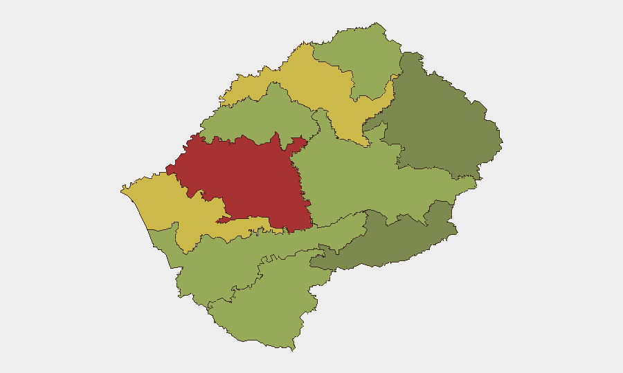
Maseru District (risk 78) and Mafeteng District (risk 65) account for the majority of documented risk and warrant prioritized monitoring. Risk concentration in the capital and southwestern regions reflects higher population density, transnational crime corridors, and historical vulnerability to organized trafficking networks. Mid-tier districts (Leribe, Berea, Mohale's Hoek) present moderate risk; eastern and southern districts (Mokhotlong, Qacha's Nek) remain relatively lower-risk. Corporate personnel and asset operations in Maseru should maintain baseline vigilance and contingency protocols.
How GeoBit Would Assist
Intel Sweep & OSINT Fusion would provide continuous, multi-language monitoring of Lesotho's news, social-media, and regional actor networks to detect early signals of protest, crime escalation, or trafficking activity before they reach mainstream reporting. AOI Monitoring & Early Warning applied to Maseru District and key border crossing points would generate real-time alerts on roadblocks, security-force deployments, or civil unrest, enabling duty-of-care teams to brief and relocate personnel ahead of disruption. Routing & Network Analysis combined with GIS & Spatial Analysis would allow security teams to map alternative travel corridors and safe zones, critical given Lesotho's terrain and the concentration of risk in northern and southwestern corridors.
7-Day Outlook
No escalation indicators are present. The security environment is forecast to remain consistent with baseline conditions through early August, barring unexpected external shocks (e.g., regional spillover from South Africa, political decisions by Lesotho's government). Routine monitoring of transnational crime networks and any signals of labor unrest in the textile and mining sectors remains warranted as a precaution.
GeoBit Daily Security Brief | Lesotho | 2026-07-28
Highest-Risk Areas — Ranked
| # | State / Region | Risk |
|---|---|---|
| 1 | Maseru District | 78 |
| 2 | Mafeteng District | 65 |
| 3 | Leribe District | 62 |
| 4 | Berea District | 58 |
| 5 | Mohale's Hoek District | 52 |
| 6 | Butha-Buthe District | 48 |
| 7 | Thaba-Tseka District | 45 |
| 8 | Quthing District | 42 |
| 9 | Mokhotlong District | 38 |
| 10 | Qacha's Nek District | 28 |
Previous Daily Briefs
A new Lesotho brief is written every day — each with its own risk map and downloadable CSV. Here's the last week; use the calendar to go further back.
📅 Browse every day by calendar →
Highlighted days have a brief. Tap a day for that day's map & analysis, or “csv” for that day's dataset ($5).
Atlas — our AI intelligence desk — emails them this snapshot personally. Nothing else, no list.