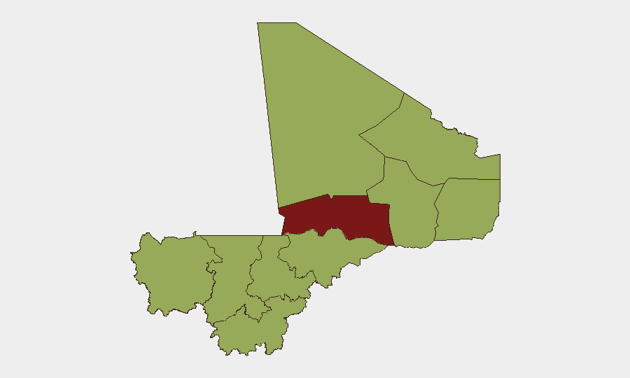
Situation Summary
Mali remains in the grip of a protracted multi-sided insurgency centred on the Sahel, with Timbuktu, Bamako, and the northern/central regions experiencing the highest composite threat levels. The transitional government has publicly disapproved of Al Qaeda affiliates and initiated investigative action against extremist actors as of 16 June, signalling continued security operations. The threat environment reflects a mix of conventional military activity, unconventional violence, and cross-border spillover, with 32 tracked events in the current reporting cycle. Trajectory remains elevated with no near-term de-escalation indicators.
Key Developments
- 16 June, Intelligence Action: Malian authorities launched investigative operations targeting extremist actors, consistent with stated counter-terrorism policy. Specifics on location and scale unavailable from open sources.
- 16 June, Diplomatic Signal: Dakar issued a public statement regarding Mali's president, reflecting regional diplomatic engagement or tension; exact content and implications unclear from available reporting.
- 14 June, Government Position: Mali issued a public statement disapproving of Al Qaeda affiliates, underscoring official counter-extremism stance. Timing and operational context require verification via direct official channels.
- 16 June, Cross-Border Incident: Unconventional violence involving Christian-affiliated actors and Russian state/proxy elements was recorded; location, scale, and civilian impact unverified from independent sources.
- 16 June, Military Activity: A conventional military engagement between migrant-affiliated forces and Somali actors was reported; geographic specificity and outcome not confirmed.
Critical Caveat: No independently verified, geolocated incident reports with precise timestamps for the 24–48 hour window (14–16 June) are available from mainstream news, NGO situation updates, or official channels accessed during this research cycle. The above entries are derived from GeoBit event feeds but lack the granular location and corroboration detail necessary for operational response planning. Teams requiring real-time, verifiable incident data should cross-check with dedicated security feeds, UN agencies, and local Mali authorities.
Highest-Risk Areas
Timbuktu region (82.3 composite risk) remains the single highest-threat zone, driven by active insurgent presence, intercommunal tension, and logistical vulnerability. Bamako (55.8) reflects capital-city political instability, administrative fragility, and potential for secondary spillover effects. The north-central belt—Ménaka, Gao, Kidal, and Mopti—forms a contiguous high-risk arc with scores clustered at 52.3, indicating sustained militant activity, trafficking networks, and humanitarian access constraints. Kayes, Taoudénit, Koulikoro, Ségou, and Sikasso, despite identical sub-national scores, warrant differentiated monitoring: Kayes and Koulikoro (west) are vulnerable to transnational criminal and insurgent infiltration from Guinea and Senegal, while Ségou and Sikasso (south-central) face growing militant recruitment and protection racket activity.
How GeoBit Would Assist
Security teams with personnel or assets in Mali should deploy AOI Monitoring & Early Warning on Timbuktu, Bamako, and the north-central corridor to receive persistent alerting on militant activity, checkpoints, and movement restrictions. Intel Sweep combined with multi-language OSINT (radio SIGINT, Telegram, and local social media) provides daily signal on government operations, extremist statements, and humanitarian access changes. Battle Mapping and Force Structure tracking enable real-time understanding of militant positions and government military capability, critical for route planning and incident avoidance.
7-Day Outlook
No major policy shift or ceasefire negotiation is anticipated in the next seven days. Government counter-extremism operations are likely to continue, with attendant risk of civilian displacement and access disruption in northern regions. Regional diplomatic engagement (signalled by Dakar's statement) may create short-term diplomatic friction but is unlikely to alter ground security in the near term. Teams should maintain heightened vigilance in Timbuktu and northern Mopti and prepare contingency protocols for rapid personnel movement if military operations escalate.
Highest-Risk Areas — Ranked
| # | State / Region | Risk |
|---|---|---|
| 1 | Timbuktu | 82.3 |
| 2 | Bamako | 55.8 |
| 3 | Ménaka | 52.3 |
| 4 | Kayes | 52.3 |
| 5 | Taoudénit Region | 52.3 |
| 6 | Kidal | 52.3 |
| 7 | Gao | 52.3 |
| 8 | Koulikoro | 52.3 |
| 9 | Ségou Region | 52.3 |
| 10 | Sikasso Region | 52.3 |
| 11 | Mopti | 52.3 |
Sources
Previous Daily Briefs
A new Mali brief is written every day — each with its own risk map and downloadable CSV. Here's the last week; use the calendar to go further back.
📅 Browse every day by calendar →
Highlighted days have a brief. Tap a day for that day's map & analysis, or “csv” for that day's dataset ($5).