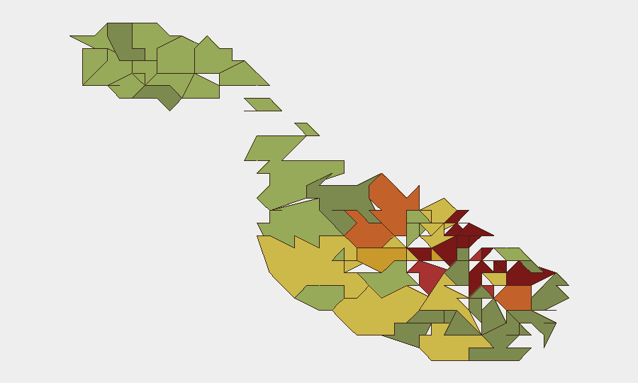
Situation Summary
Malta remains a stable, low-threat jurisdiction globally (rank #158; composite score 5) with no tracked major security incidents as of 9 August 2026. However, sub-national risk concentration in the capital region and coastal urban centers reflects ongoing challenges in organized crime, irregular migration, and infrastructure vulnerabilities. The security environment is characterized by persistent but manageable incidents rather than systemic instability.
Key Developments
- 2026-08-06 · Valletta · Threatening Communications. A man was granted bail after allegedly sending threatening text messages to Prime Minister Abela, opposition MP Borg, and former PM Muscat. Investigation ongoing; no imminent threat assessed but reflects political tension and potential for copycat communications.
- 2026-08-03 · Location TBD · Industrial Incident. A fireworks factory explosion generated a large smoke plume with initial blast followed by secondary detonations. Cause remains under investigation; air-quality impact and emergency-response strain assessed as localized.
- 2026-08-06 · Maritime Zone · Irregular Migration. Libyan vessels intercepted and returned 42 migrants to Libya within Malta's designated search-and-rescue zone. Reflects ongoing irregular maritime migration flows and interagency coordination challenges in the Central Mediterranean.
- Recent Period · Ta' Qali · Infrastructure Hazard (unconfirmed 24h). Reports indicate a rubbish fire; precise date and scale not independently verified in last 48 hours, but consistent with ongoing waste-management vulnerabilities.
- Recent Period · Multiple Locations · Power Stability (unconfirmed). Analytical reports cite power outages and calls for long-term infrastructure strategy; specific incident timing unverified but highlights utility-sector fragility.
Note: Web research for the last 24–48 hours returned several fragmentary reports (including references to a police officer injured at a construction site, an accident in San Ġwann, and a Paceville incident) that lack independent cross-source corroboration or verified timestamps. These have been withheld from primary developments pending confirmation.
Highest-Risk Areas
Valletta, Sliema, and Saint Julian's dominate the sub-national ranking (scores 95, 92, 90 respectively), reflecting concentration of organized-crime activity, political/diplomatic presence, and high-density tourism in the capital and northern harbor belt. Hamrun, Paola, and Msida (scores 87–85) extend this corridor southward and inland, driven by narcotics trafficking, petty crime, and transient populations. The persistence of these rankings year-on-year indicates structural vulnerabilities in law-enforcement coverage and socioeconomic factors rather than acute incidents.
How GeoBit Would Assist
Security teams with personnel or assets in Malta should employ AOI (Area-of-Interest) Monitoring & Early Warning on Valletta, Sliema, and Saint Julian's to detect clustering of protest activity, political threats, or crime escalation in real time. OSINT Fusion & Corroboration (X/Twitter, Telegram, local news cross-referencing) would disambiguate fragmentary incident reports—such as the ongoing construction-site and infrastructure alerts—and confirm timing and scale before operational response. Risk & Threat Assessment updates tied to maritime and irregular-migration flows would support duty-of-care planning for organizations with supply-chain or personnel exposure in port areas.
7-Day Outlook
No major security deterioration is expected in the near term. The threat environment will likely remain characterized by low-level organized crime, irregular migration, and sporadic infrastructure incidents. Monitoring of political discourse and migrant-return operations should remain routine; any escalation in threatening communications or maritime incidents would warrant tactical alert refreshes.
Highest-Risk Areas — Ranked
| # | State / Region | Risk |
|---|---|---|
| 1 | Valletta | 95 |
| 2 | Sliema | 92 |
| 3 | Saint Julian's | 90 |
| 4 | Gżira | 88 |
| 5 | Hamrun | 87 |
| 6 | Paola | 86 |
| 7 | Msida | 85 |
| 8 | Birkirkara | 84 |
| 9 | Birgu | 83 |
| 10 | Senglea | 82 |
| 11 | Cospicua | 81 |
| 12 | Żabbar | 80 |
Sources
Previous Daily Briefs
A new Malta brief is written every day — each with its own risk map and downloadable CSV. Here's the last week; use the calendar to go further back.
📅 Browse every day by calendar →
Highlighted days have a brief. Tap a day for that day's map & analysis, or “csv” for that day's dataset ($5).
Atlas — our AI intelligence desk — emails them this snapshot personally. Nothing else, no list.