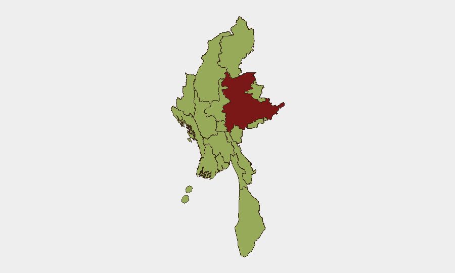
Situation Summary
Myanmar remains in active civil conflict with composite threat score 73 (#27 globally), driven by fragmented armed opposition to military rule across multiple regions. The security environment has shifted markedly in the past 48 hours following a high-level Beijing endorsement of the junta leadership and a concurrent tightening of intelligence/security operations targeting foreign analysts and advocacy professionals working on Myanmar issues. The convergence of deepened China–Myanmar strategic alignment, new detention of foreign risk professionals, and ongoing sub-national armed activity creates a compound risk profile for international personnel and assets.
Key Developments
- Beijing, China – 16 June 2026: Chinese President Xi Jinping met Myanmar junta leader Min Aung Hlaing, publicly endorsing his political leadership and pledging deeper strategic cooperation under the China–Myanmar Economic Corridor framework, with explicit emphasis on security guarantees for cross-border infrastructure projects.[1][2]
- Beijing, China – 16 June 2026: China and Myanmar signed 18 cooperation memorandums covering cross-border transportation, free trade, disaster assistance, health, and media, with Chinese officials signaling acceleration of CMEC construction across western, northern, and eastern corridors.[1][2]
- Yangon International Airport, Yangon Region – 11 June 2026 (arrest confirmed 15–16 June): Adam Castillo, former American Chamber of Commerce president and security-risk firm owner, was detained on arrival and formally arrested over alleged suspicious financial transactions; Myanmar military outlets cited a complaint from AmCham Myanmar.[3][6]
- Kunming, Yunnan Province, China – Arrest confirmed 12 June 2026 (reported last 48h): Chinese authorities arrested Min Zin, a US citizen and executive director of the Institute for Strategy and Policy (Myanmar-focused think tank), on espionage charges alleging he endangered Chinese national security, indicating expanded security perimeter around Myanmar-related research and cross-border analytical work.[4]
- Regional intelligence posture – Last 48 hours: Chinese state and affiliated channels amplified messaging that Beijing "firmly supports" Myanmar's sovereignty and the military government, while simultaneously prosecuting espionage cases against foreign analysts; this dual signal indicates a tightening security and surveillance environment around Myanmar policy work and transit via China.[2][4][5]
- Seismic activity: M 4.4 earthquake recorded 82 km ENE of Loikaw, Shan State (recent); flooding reported across Myanmar in same period, complicating access and potentially affecting supply chains and population displacement.
Highest-Risk Areas
Shan State dominates the sub-national ranking (81.4) and is the primary locus of armed conflict, ethnic insurgency, and cross-border activity; Tanintharyi, Chin, Sagaing, Kachin, and Wa State (Northern Region) follow at 51.4, each hosting armed opposition forces and criminal networks. Yangon and Naypyitaw, despite lower composite scores (51.4), carry asymmetric risk due to presence of government security apparatus and increased detention/surveillance activity targeting foreigners, as evidenced by the Castillo and Min Zin arrests. Urban centers should not be assumed safe; intelligence and law-enforcement activity is intensifying against foreign professionals in the policy, advocacy, and risk-analysis space.
How GeoBit Would Assist
Security teams should deploy AOI Monitoring & Early Warning on key transport hubs (Yangon International Airport, Mandalay) and Shan State conflict zones to track military/opposition movement and checkpoint activity. Network & Actor Analysis combined with Intel Sweep (X/Telegram OSINT, multi-language search) will surface real-time intelligence on detention trends, regime security posture, and cross-border intelligence operations affecting foreign personnel. Routing & Network Analysis will identify safer transit corridors and alternative supply/evacuation pathways given deteriorating Shan State and northern-border conditions.
7-Day Outlook
Chinese strategic alignment with the junta will likely intensify infrastructure-security operations in border zones, creating friction points for foreign nationals in northern and western regions. Expect continued selective detention of foreign analysts and advocacy professionals as the regime consolidates control under external backing. Armed conflict intensity in Shan and Kachin is forecast to remain elevated with seasonal monsoon constraints on large-scale operations.
Highest-Risk Areas — Ranked
| # | State / Region | Risk |
|---|---|---|
| 1 | Shan State | 81.4 |
| 2 | Tanintharyi Region | 51.4 |
| 3 | Chin | 51.4 |
| 4 | Sagaing Region | 51.4 |
| 5 | Kachin State | 51.4 |
| 6 | Wa State (Northern Region) | 51.4 |
| 7 | Magway | 51.4 |
| 8 | Mandalay | 51.4 |
| 9 | Rakhine | 51.4 |
| 10 | Ayeyarwady | 51.4 |
| 11 | Yangon | 51.4 |
| 12 | Naypyitaw Union Territory | 51.4 |
Sources
Previous Daily Briefs
A new Myanmar brief is written every day — each with its own risk map and downloadable CSV. Here's the last week; use the calendar to go further back.
📅 Browse every day by calendar →
Highlighted days have a brief. Tap a day for that day's map & analysis, or “csv” for that day's dataset ($5).