Situation Summary
Nigeria remains the second-highest threat environment globally, with 504 tracked security events driven primarily by active insurgency, widespread banditry, and kidnapping across multiple regions. Recent reporting indicates that the combined volume of insurgency, kidnap, and banditry incidents over the past two weeks has exceeded levels recorded across the entire 2003–2010 period, signaling a marked acceleration in nationwide insecurity. Urban crime, particularly armed robbery, continues to spike in major commercial centers. The security deterioration is occurring against a backdrop of political debate over police reform and new counterbandit measures, but operational capacity gaps remain acute.
Key Developments
- Plateau State (Kuru, 21 June 2026 – morning): NIPSS (National Institute for Policy and Strategic Studies) near Jos confirmed security incidents on or near campus this morning; security agencies responded, situation was controlled, and operations resumed. Formal investigation launched; authorities cautioned against unverified social-media reporting.
- Northwest Nigeria – Katsina/Zamfara axis (recent announcement): State governors announced newly implemented measures including a blanket ban on jerrycan sales, purchase, transportation, and storage of petroleum products, targeting disruption of bandit fuel supply chains in response to escalating kidnappings and criminal gang activity.
- Imo State – Owerri (18 June 2026, circulating in last 48 hours): Armed robbery gang of six or more conducted coordinated residential raids on seven flats in a single neighborhood overnight; residents fled; security response occurred after initial looting. Incident documented on CCTV and widely shared on Nigerian social platforms as indicator of deteriorating urban security.
- National (last 24–48 hours): Security analyst public statement asserted that combined insurgency, kidnap, and banditry incidents in the past two weeks exceed cumulative totals from 2003–2010, framing current surge as historically unprecedented in recent decades.
- National governance (morning broadcast, latest cycle): State governors reiterated push for constitutional state police reform with explicit safeguards and legal framework, tied directly to ongoing kidnapping and banditry spike. Federal-level discussion of institutional security response remains active.
Highest-Risk Areas
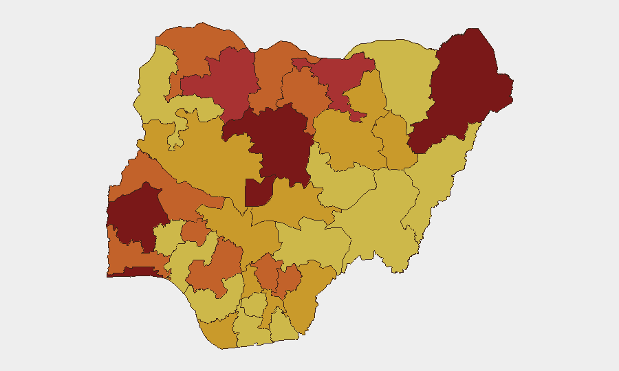
Lagos (100), Kaduna (96.3), and the Federal Capital Territory (81.8) drive the overall composite threat ranking, reflecting persistent urban crime, insurgency-adjacent activity, and kidnapping near the capital. The northern tier—Borno, Zamfara, Jigawa, Sokoto, and Kano—remains critically exposed to active banditry and jihadist operations; Borno (80.3) and Zamfara (79.7) show the highest northern threat scores, with Kaduna (96.3) positioned as a transit and high-yield kidnapping zone. Southeast states (Enugu, Ebonyi, Imo) are experiencing upward pressure from organized armed robbery and cult activity. The concentration of risk in Lagos and Kaduna reflects both population density and criminal/insurgent targeting of commercial and political assets.
How GeoBit Would Assist
Corporate security teams would deploy AOI Monitoring & Early Warning on high-density zones in Lagos, Kaduna, and Abuja to receive real-time alerts on crowd movements, armed activity, and incident clustering. OSINT Fusion & Corroboration across social media, local news, and Telegram channels would cross-verify emerging kidnap networks, bandit logistics, and supply-chain disruptions (e.g., fuel bans). Routing & Network Analysis would enable alternative route planning for personnel movement, avoiding known bandit corridors and checkpoints in the northwest and around Kaduna.
7-Day Outlook
Banditry and kidnapping activity in the northwest and north-central zones will likely persist at elevated levels despite new fuel-ban measures, which require weeks to degrade criminal logistical networks. Urban armed robbery in Lagos and secondary cities may continue short-term as criminal groups exploit police resource constraints. Security force operations and state-police reform discussions will intensify but will not produce immediate operational capacity increases.
Highest-Risk Areas — Ranked
| # | State / Region | Risk |
|---|---|---|
| 1 | Lagos State | 100 |
| 2 | Kaduna State | 96.3 |
| 3 | Federal Capital Territory | 81.8 |
| 4 | Oyo State | 81.4 |
| 5 | Borno State | 80.3 |
| 6 | Zamfara State | 79.7 |
| 7 | Jigawa State | 76.2 |
| 8 | Ekiti State | 75.6 |
| 9 | Sokoto State | 75.4 |
| 10 | Enugu State | 75 |
| 11 | Ebonyi State | 74.1 |
| 12 | Kano State | 73.7 |
Sources
Previous Daily Briefs
A new Nigeria brief is written every day — each with its own risk map and downloadable CSV. Here's the last week; use the calendar to go further back.
📅 Browse every day by calendar →
Highlighted days have a brief. Tap a day for that day's map & analysis, or “csv” for that day's dataset ($5).