Situation Summary
Panama's security environment remains volatile, with composite threat score of 35 and 7 tracked events concentrated in the past 72 hours. Urban violence, particularly gang-related shootings and road fatalities in Panama City and Colón, is driving short-term risk, while nationwide police enforcement operations (Plan Firmeza) signal sustained action against organized crime and micro-trafficking networks. The frontier regions—especially Darién and Colón—remain endemic risk zones, but current tactical pressure appears concentrated in major urban centers where corporate and expatriate presence is highest.
Key Developments
- Panama City, Panamá Viejo (Vía Cincuentenario), 23 July morning: Shootout between two vehicles resulted in one fatality and three detentions; police investigation ongoing into gang-related violence. Secondary incident—bullet-riddled vehicle recovered in Campo Lindbergh—under investigation for possible connection.
- Panama City, multiple avenues (Avenida Domingo Díaz), 27–28 July: Acute concentration of fatal and injury-causing motorcycle accidents in urban traffic corridors; specific incidents cited as short-term commute risk for logistics and personnel movement.
- Colón Province, urban neighborhoods (Río Alejandro, Alto de Los Lagos), 27–28 July: Active armed violence and homicides reported; law-enforcement operations ongoing, indicating sustained gun-violence risk in the province.
- Nationwide, Plan Firmeza operations (72 hours to 26 July): Police report 574 arrests (321 on judicial warrants), 123 search warrants executed, 23 firearms seized, plus drugs and stolen vehicles recovered; reflects coordinated counter-crime campaign across multiple provinces.
- Nationwide, Operation "Anonymus" (24–25 July, ongoing): Federal arrests of firearms-component smuggling suspects; Ministerio Público coordination active; sustained risk around weapons trafficking in transit and urban zones.
- Nationwide, 24-hour police report (to 26 July): 132 arrests for micro-trafficking and related offenses; 7 firearms and 635 rounds confiscated; 61 traffic accidents with 6 injuries, underscoring dual risk from criminal activity and road safety.
Highest-Risk Areas
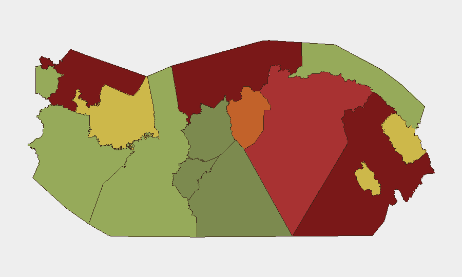
Darién (95), Colón (88), and Bocas del Toro (82) drive regional risk via trafficking routes, organized-crime presence, and limited state authority. However, Panamá Province (78) and Panamá Oeste (75) now warrant elevated attention because they encompass Panama City and its surrounding urban corridor—the operational center for gang violence, police enforcement, and corporate/diplomatic activity. The metropolitan zone's concentration of people, assets, and infrastructure means that even medium-intensity violence spikes (as seen in the past 48 hours) pose acute duty-of-care risk. Lower-ranked provinces (Chiriquí 48, Guna Yala 42, Coclé 35) remain relatively stable but should not be assumed secure; border and maritime smuggling activity persists.
How GeoBit Would Assist
Security teams would deploy AOI Monitoring & Early Warning on Panama City (Panamá Viejo, Campo Lindbergh, major avenues), Colón, and Darién to detect homicides, gang activity, and police operations in near-real time. Intel Sweep and OSINT fusion (X/Twitter, Telegram, local news, radio SIGINT) provide continuous signal on weapons trafficking, enforcement actions, and criminal network chatter. Routing & Network Analysis enables alternative journey planning around active violence zones and traffic fatality hotspots, protecting personnel and logistics.
7-Day Outlook
Plan Firmeza and Operation Anonymus momentum will likely sustain elevated enforcement activity and associated criminal-group responses through early August, increasing short-term volatility. Road-safety incidents and localized gang violence in Panama City and Colón are expected to remain elevated but manageable with real-time threat awareness. Frontier provinces (Darién, Colón, Bocas del Toro) will continue serving as trafficking transit zones, but corporate risk remains primarily urban and route-dependent rather than pervasive.
Highest-Risk Areas — Ranked
| # | State / Region | Risk |
|---|---|---|
| 1 | Darién | 95 |
| 2 | Colón | 88 |
| 3 | Bocas del Toro | 82 |
| 4 | Panamá Province | 78 |
| 5 | Panamá Oeste | 75 |
| 6 | Ngäbe-Buglé | 68 |
| 7 | Emberá-Wounaan | 62 |
| 8 | Veraguas | 58 |
| 9 | Chiriquí | 48 |
| 10 | Naso Tjër Di | 45 |
| 11 | Guna Yala | 42 |
| 12 | Coclé | 35 |
Sources
Previous Daily Briefs
A new Panama brief is written every day — each with its own risk map and downloadable CSV. Here's the last week; use the calendar to go further back.
📅 Browse every day by calendar →
Highlighted days have a brief. Tap a day for that day's map & analysis, or “csv” for that day's dataset ($5).
Atlas — our AI intelligence desk — emails them this snapshot personally. Nothing else, no list.