Situation Summary
Papua New Guinea remains a composite mid-tier risk environment (rank #68 globally) with acute regional instability concentrated in the Highlands and National Capital District. No major new security incidents have been corroborated in the past 24–48 hours; the security picture is stable at baseline, though upstream geopolitical activity and scheduled military exercises signal potential near-term disruption vectors. Underlying drivers—tribal violence in remote provinces, urban crime in Port Moresby, and infrastructure fragility—remain endemic and show no signs of acute deterioration.
Key Developments
- Port Moresby, Wewak, Lae — 8 July 2026: U.S. Embassy notification of Exercise Tamiok Strike 2026 (13–24 July), a joint PNGDF–U.S.–Australian military exercise. Expect localized airspace restrictions, road closures, and heightened military convoy activity near major urban centers and airports during the exercise window; may disrupt commercial logistics and create short-term access constraints.
- Regional security posture — 7–8 July 2026: Recent diplomatic and defense statements confirm PNG's alignment with Australia and the U.S. in regional security architecture, including joint capacity-building and counter-influence efforts. Signals ongoing foreign military presence and advisory expansion, particularly around Port Moresby and infrastructure hubs; may trigger localized protest or labor-relations friction in some areas.
- No acute incidents reported (last 24–48 hours): Web research confirms no corroborated reports of major rioting, mass-casualty violence, infrastructure failure, or political instability dated to 7–8 July 2026. Baseline crime and tribal conflict activity in the Highlands provinces continues but remains within typical patterns.
- Seismic and environmental hazards (recent, non-security): A magnitude 5.0 earthquake occurred 110 km SE of Kimbe; active wildfire detected; circulating vaccine-derived poliovirus type 2 (cVDPV2) remains in circulation. These are health and infrastructure risk vectors rather than security incidents but warrant vigilance by corporate health and supply-chain teams.
Highest-Risk Areas
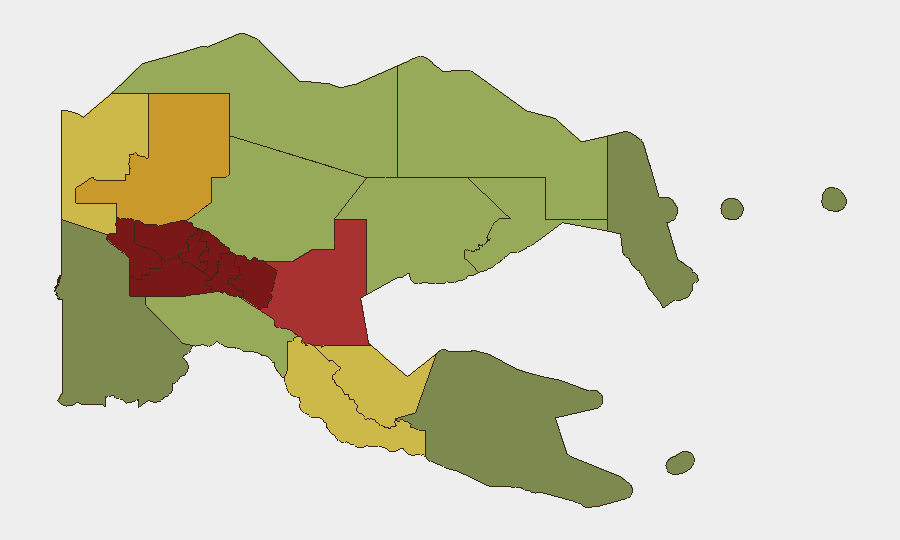
The Southern Highlands, Enga, and Hela provinces drive PNG's composite risk score, each with ratings exceeding 94. These regions are characterized by entrenched clan and tribal conflict, limited state presence, and sporadic but lethal violence; corporate assets and personnel in or transiting these areas face elevated exposure to armed confrontation and criminal activity. The National Capital District (rank 7, score 85) carries distinct urban-crime and infrastructure risks. Eastern Highlands and Western Highlands (ranks 4–5) complete the upper-tier cluster. Highlands instability is chronic and geographically isolated, whereas National Capital District risks are acute and affect logistics, expatriate security, and government/diplomatic operations.
How GeoBit Would Assist
AOI Monitoring & Early Warning on high-risk provinces (Southern Highlands, Enga, Hela) would provide persistent watch and alerting for emerging conflict, roadblock activity, or mass-movement events. Network & Actor Analysis paired with OSINT fusion (X/Twitter, local news, radio SIGINT) would track tribal faction statements and mobilization signals. Routing & Network Analysis would enable real-time alternative-route planning for personnel and cargo around blocked or unsafe corridor segments, while satellite & imagery analysis would corroborate ground reports of infrastructure damage or blockades.
7-Day Outlook
Exercise Tamiok Strike (13–24 July) will create temporary but predictable disruption in Port Moresby, Wewak, and Lae; plan logistics and travel around published exercise windows. No indicators suggest escalation in Highlands violence or Port Moresby crime over the next seven days; risk posture remains at baseline. Monitor diplomatic messaging and Australian defense-partnership announcements for signals of expanded foreign presence or localized protest.
Highest-Risk Areas — Ranked
| # | State / Region | Risk |
|---|---|---|
| 1 | Southern Highlands | 98 |
| 2 | Enga | 96 |
| 3 | Hela | 94 |
| 4 | Eastern Highlands | 92 |
| 5 | Western Highlands | 90 |
| 6 | Jiwaka | 88 |
| 7 | National Capital District | 85 |
| 8 | Simbu | 82 |
| 9 | Morobe | 78 |
| 10 | East Sepik | 72 |
| 11 | Sandaun | 68 |
| 12 | Oro | 66 |
Sources
Previous Daily Briefs
A new Papua New Guinea brief is written every day — each with its own risk map and downloadable CSV. Here's the last week; use the calendar to go further back.
📅 Browse every day by calendar →
Highlighted days have a brief. Tap a day for that day's map & analysis, or “csv” for that day's dataset ($5).
Atlas — our AI intelligence desk — emails them this snapshot personally. Nothing else, no list.