Situation Summary
Samoa remains a low-threat environment with no corroborated security incidents, violent crime, civil unrest, or infrastructure disruption reported in the last 24–48 hours. The national composite threat score reflects minimal tracked event activity. The primary operational risk remains health-related: an ongoing dengue outbreak continues to strain healthcare capacity, but has not triggered movement restrictions, public disorder, or security-driven disruptions. The security posture remains stable, with routine governance and commercial activity continuing normally across the country.
Key Developments
- Samoa (national), 26–27 July 2026: No new violent crime, protests, civil unrest, or terrorism incidents reported across multi-source monitoring feeds in the last 48 hours; all international travel advisories maintain "normal safety precautions" guidance with no recent escalations.
- Apia and provincial centers, 26–27 July 2026: No demonstrations, political gatherings, or crowd-related disturbances reported in the capital or wider provincial areas over the last 24–48 hours; normal commercial and administrative activity continues.
- Samoa (national), ongoing through 27 July 2026: Dengue outbreak remains the primary elevated operational health risk; foreign-travel advisories continue to flag pressure on healthcare services, but no public-health emergency declarations, facility closures, or systemic disruptions have been reported in the last two days.
- National University of Samoa, earlier July 2026 (background context, not current): Two student-fight incidents were recorded on social media and investigated by campus disciplinary and police units; no new university-related unrest has been reported since, and the matter remains under routine investigation with no spillover into the wider security environment.
- Samoa (national), last 24–48 hours: Cross-checked social-media and open-source monitoring streams show no widely shared, independently confirmed reports of large-scale criminal activity, politically motivated violence, or organized disturbances beyond routine, small-scale incidents that have not triggered official alerts or advisory changes.
Highest-Risk Areas
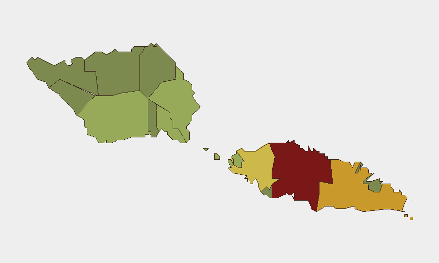
Tuamasaga (risk 85) and Ātua (risk 71) drive the sub-national ranking and warrant primary monitoring focus; both districts contain or are adjacent to Apia and carry higher population density, commercial concentration, and event frequency. Aʻana (risk 62) and Aiga-i-le-Tai (risk 55) represent secondary risk zones, while the southern and eastern districts (Palauli, Satupaʻitea, Gagaʻemauga, and below) remain low-risk. The concentration of risk in the upper-western and central districts reflects urban density and economic activity rather than acute current threats; dengue exposure is distributed nationally but most acute in areas with higher healthcare-access gaps.
How GeoBit Would Assist
Security teams with personnel or assets in Samoa would employ AOI Monitoring & Early Warning to maintain persistent watch on high-risk districts (particularly Tuamasaga and Ātua) with alerting on civil unrest, crowd activity, or crime-spike signals; Intel Sweep and global event feeds to track any sudden political, security, or health-system developments; and Environmental & Health monitoring to correlate dengue-outbreak progression with healthcare strain and any secondary operational impacts. Network & Actor Analysis would flag emerging social-media coordination of protests or unrest before they materialize as physical incidents.
7-Day Outlook
No acute security drivers are forecast to emerge in the next seven days. The dengue outbreak will likely remain the primary operational concern, with routine healthcare-capacity pressure continuing but no indication of systemic failure or secondary civil unrest. Samoa's low-threat environment is expected to persist, pending any unforeseen political, weather-related, or health-system developments.
Highest-Risk Areas — Ranked
| # | State / Region | Risk |
|---|---|---|
| 1 | Tuamasaga | 85 |
| 2 | Ātua | 71 |
| 3 | Aʻana | 62 |
| 4 | Aiga-i-le-Tai | 55 |
| 5 | Faʻasaleleaga | 48 |
| 6 | Palauli | 42 |
| 7 | Satupaʻitea | 38 |
| 8 | Gagaʻemauga | 35 |
| 9 | Gagaʻifomauga | 32 |
| 10 | Vaisigano | 28 |
| 11 | Vaʻa-o-Fonoti | 23 |
Previous Daily Briefs
A new Samoa brief is written every day — each with its own risk map and downloadable CSV. Here's the last week; use the calendar to go further back.
📅 Browse every day by calendar →
Highlighted days have a brief. Tap a day for that day's map & analysis, or “csv” for that day's dataset ($5).
Atlas — our AI intelligence desk — emails them this snapshot personally. Nothing else, no list.