Situation Summary
Solomon Islands remains in a stable security environment with no verified incidents reported in the last 24–48 hours. Underlying structural risks—violent crime, economic disruption, and limited police capacity—persist in urban centers, particularly Honiara and Guadalcanal, but these do not represent acute deterioration. The security trajectory remains flat, with no indicators of imminent escalation or systemic unrest at the national level.
Key Developments
- Honiara, prospective — Prime Minister Matthew Wale announced that a "ship rider" agreement permitting US Coast Guard patrols alongside local police will be signed in Honiara in the coming week. This represents a planned enhancement to maritime security and surveillance capacity, though operational impact remains prospective rather than immediate.
- Nationwide — As of 21–22 July 2026, official composite security briefs reported zero verified security incidents, unrest, crime disruptions, or travel-risk events in the preceding 24–48-hour window. Transport, port, and airport operations continued normal across all provinces.
- Travel advisories (Australia, New Zealand) — Current official guidance maintains that Solomon Islands faces elevated but *stable* crime and unrest risks, with potential for civil disturbance to arise with limited notice. No new specific incidents or advisory escalations were issued in the last 24–48 hours.
- Local media focus — Recent domestic reporting emphasizes infrastructure, transport projects, and positive social events (e.g., vessel handover in Honiara, Girls in ICT Day). The absence of security-related headlines in local outlets aligns with the absence of verified recent incidents.
Highest-Risk Areas
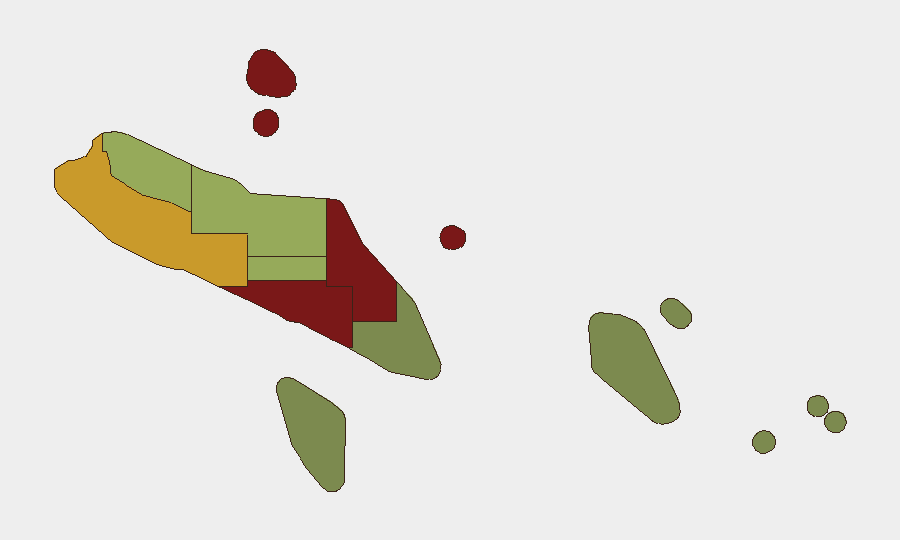
Honiara (risk 92) and Guadalcanal province (risk 88) dominate the sub-national risk landscape, driven by persistent urban violent crime, gang activity, limited police operational capacity, and economic frustration. Malaita (risk 85) follows as the third-highest-risk province, reflecting similar structural vulnerabilities. Western (risk 72) also registers elevated risk. These four regions account for the majority of recorded criminal incidents and civil unrest events; rural and eastern provinces (Temotu, Rennell and Bellona) carry substantially lower exposure. Risk in high-scoring areas is chronic rather than acute—organizational duty-of-care planning should assume ongoing baseline crime and potential for rapid community mobilization rather than imminent large-scale violence.
How GeoBit Would Assist
Teams with personnel or assets in Solomon Islands should employ Area-of-Interest Monitoring & Early Warning on Honiara and Central Guadalcanal to detect rapid sentiment shifts, protest assembly, or police/military activation via open-source feeds, social media, and local media. Multi-language OSINT fusion across local news outlets, community messaging platforms, and regional reporting would provide corroborated early notice of emerging unrest. Network & Actor Analysis can map criminal and political actor landscapes in high-risk urban zones to inform route planning and event-response protocols.
7-Day Outlook
Security conditions are expected to remain stable in the immediate term, with no indicators suggesting imminent escalation. Ongoing baseline crime and sporadic unrest in urban centers will persist; the planned ship rider agreement announcement may receive localized attention but is unlikely to drive security deterioration. Teams should maintain standard heightened awareness in Honiara and Guadalcanal while treating the broader archipelago as lower-risk for near-term operations.
Highest-Risk Areas — Ranked
| # | State / Region | Risk |
|---|---|---|
| 1 | Honiara | 92 |
| 2 | Guadalcanal | 88 |
| 3 | Malaita | 85 |
| 4 | Western | 72 |
| 5 | Choiseul | 58 |
| 6 | Isabel | 52 |
| 7 | Central Province | 48 |
| 8 | Makira-Ulawa | 38 |
| 9 | Rennell and Bellona | 22 |
| 10 | Temotu | 18 |
Sources
Previous Daily Briefs
A new Solomon Islands brief is written every day — each with its own risk map and downloadable CSV. Here's the last week; use the calendar to go further back.
📅 Browse every day by calendar →
Highlighted days have a brief. Tap a day for that day's map & analysis, or “csv” for that day's dataset ($5).
Atlas — our AI intelligence desk — emails them this snapshot personally. Nothing else, no list.