Situation Summary
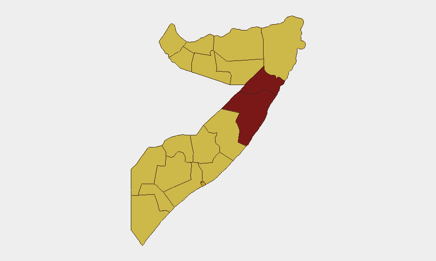
Somalia remains the 8th-highest-threat country globally (composite score 100), driven principally by active insurgency and clan-based instability across fragmented administrative regions. Recent signals include escalating diplomatic tensions with multiple ECOWAS and regional states (Zimbabwe, Nigeria, Malawi, Mozambique, Ethiopia, DRC), small-arms clashes between police and unidentified armed actors, and a U.S. aerial weapons event on 2026-07-07. The security environment is volatile and non-uniform; risk is heavily concentrated in the northeast (Mudug, Nugaal) but elevated across most peripheral states.
Key Developments
- 2026-07-07 · U.S. Aerial Weapons Event: Confirmed strike activity; no location or casualty details available in current reporting. Indicates active U.S. military engagement, likely anti-terrorism operations in coordination with or against Somali state actors.
- 2026-07-09 · Cabinet Disapproval Signal: Domestic political friction; context and affected ministry or portfolio unclear. Suggests instability in central governance.
- 2026-07-07 · Civilian Investigation: Civil casualty incident flagged; location and incident type not specified in available reporting.
- 2026-07-09 · Police vs. Armed Actors (Small Arms Combat): Localized armed clash; specific district and casualty count unknown. Consistent with ongoing clan or criminal-actor confrontations in urban or peri-urban areas.
- 2026-07-09 · Multi-State Diplomatic Demands: Coordinated pressure from five regional actors (Zimbabwe, Nigeria, Malawi, Mozambique, Ethiopia) plus DRC, all issuing demands against Somalia on the same date. Suggests unified diplomatic action, possibly related to AMISOM/ATMIS mandate, maritime claims, or refugee/migrant issues. Represents significant political isolation risk for Mogadishu.
- 2026-07-07 · Somali State Rejections (x2): Government position statements rejecting unspecified proposals or criticism.
Note on Real-Time Data Limitations: Current reporting from GeoBit event feeds provides signal metadata but lacks fine-grained geographic, casualty, and contextual detail typical of 24–48-hour operational briefs. Corporate security teams should cross-reference these signals against independent news wires (Reuters, AFP, regional outlets) and official UNDSS/diplomatic advisories for verification and granular operational detail.
Highest-Risk Areas
Mudug (risk 100) and Nugaal (risk 90.5)—both in the northeast—drive the composite country threat score; both remain Al-Shabaab strongholds with limited state capacity and ongoing inter-clan competition for territory and resources. Banaadir (Mogadishu, risk 71.6) remains elevated due to urban insurgency cells, criminal networks, and political instability; Awdal, Woqooyi Galbeed, Gedo, and the southern periphery (Bay, Middle Juba, Lower Shabelle) all register at risk 70, indicating sustained baseline threat from non-state actors, clan militias, and criminal operations. The breadth of high-risk zones reflects Somalia's lack of centralized state monopoly on force.
How GeoBit Would Assist
Teams with personnel or assets in Somalia should deploy AOI Monitoring & Early Warning on Mudug, Nugaal, and Banaadir to track incident frequency and escalation patterns in real time. Multi-language OSINT fusion (Intel Sweep, X/Telegram monitoring, Somali media scraping) combined with sentiment & temporal analysis would clarify the drivers and scope of the 2026-07-09 diplomatic demands and cabinet friction. Conflict & Military force-structure tracking and network analysis help identify which armed factions are active in proximity to specific operational sites, informing evacuation and duty-of-care protocols.
7-Day Outlook
Diplomatic tensions are likely to persist and potentially intensify absent high-level mediation; regional pressure could trigger further cabinet instability or security-force fragmentation. Insurgent activity in the northeast and urban cells in Mogadishu will continue at baseline or elevated tempo. Corporate teams should maintain heightened alertness in Banaadir and any presence in Mudug/Nugaal, and monitor official travel advisories for policy changes.
Highest-Risk Areas — Ranked
| # | State / Region | Risk |
|---|---|---|
| 1 | Mudug | 100 |
| 2 | Nugaal | 90.5 |
| 3 | Banaadir | 71.6 |
| 4 | Awdal | 70 |
| 5 | Woqooyi Galbeed | 70 |
| 6 | Gedo | 70 |
| 7 | Bakool | 70 |
| 8 | Bay | 70 |
| 9 | Middle Juba | 70 |
| 10 | Lower Shabelle | 70 |
| 11 | Sahil | 70 |
| 12 | Togdheer | 70 |
Previous Daily Briefs
A new Somalia brief is written every day — each with its own risk map and downloadable CSV. Here's the last week; use the calendar to go further back.
📅 Browse every day by calendar →
Highlighted days have a brief. Tap a day for that day's map & analysis, or “csv” for that day's dataset ($5).
Atlas — our AI intelligence desk — emails them this snapshot personally. Nothing else, no list.