Situation Summary
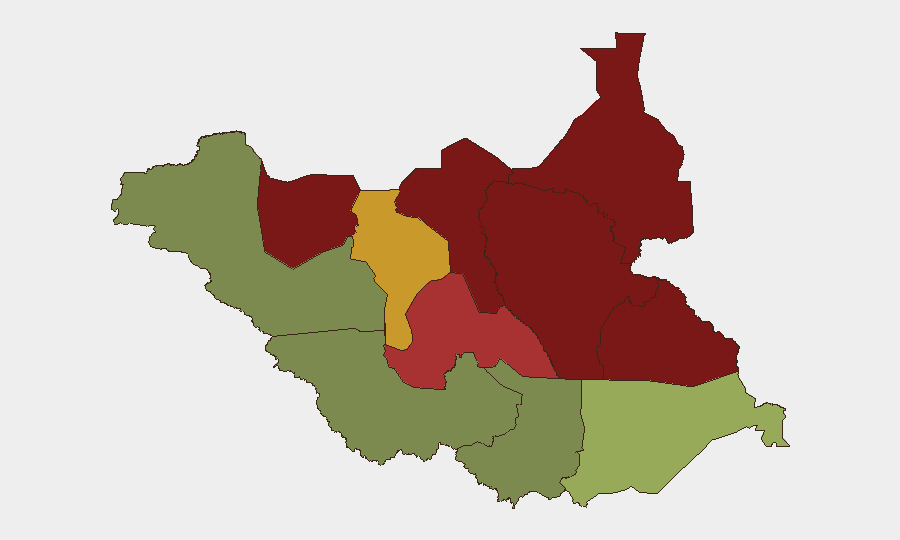
South Sudan remains a complex, fragmented operating environment with persistent inter-communal violence, localized armed group activity, and weak state authority outside the capital and major towns. Current composite threat score places the country at #38 globally, with no tracked discrete security events in the immediate reporting window. The security picture is characterized by chronic instability rather than acute crisis, though the sub-national risk distribution is highly skewed toward the oil-producing north and eastern pastoral zones.
Key Developments
No verifiable discrete security incidents have been corroborated from the last 24–48 hours. GeoBit's event tracking system has recorded no confirmed incidents in the current window. Any reporting on South Sudan incidents in this timeframe should be independently verified against multiple news outlets and local sources before operational decisions are made.
Highest-Risk Areas
Unity State (risk 95), Jonglei (93), and Upper Nile (88) account for the three highest-risk zones and are driven by competition for oil resources, cattle raiding networks, armed group presence, and weak formal security sector capacity. Greater Pibor Administrative Area (87) and Northern Bahr el Ghazal (82) reflect ongoing inter-communal conflict and criminality. These five northern and eastern states absorb nearly all organized armed activity; by contrast, Central Equatoria (35) and Western Bahr el Ghazal (28) present significantly lower risk profiles, though localized incidents remain possible. Organizations with personnel or assets in Unity, Jonglei, and Upper Nile should maintain elevated threat postures.
How GeoBit Would Assist
Organizations operating in or transiting South Sudan should employ Area-of-Interest (AOI) Monitoring & Early Warning on high-risk states (Unity, Jonglei, Upper Nile) to detect emerging armed group movement, cattle raids, or violence clusters before they affect operations. Network & Actor Analysis paired with OSINT fusion (X/Twitter, Telegram, local radio SIGINT) can provide early signals of inter-communal escalation or armed group activity 48–72 hours ahead of formal reporting. Routing & Network Analysis capabilities enable security teams to model and update safe transit corridors in real time as conditions shift, particularly for personnel moving between Juba and oil fields or humanitarian access zones. Regular conflict mapping and sentiment analysis on local language social media streams provide ground-truth context that official channels often lag.
7-Day Outlook
No acute escalation is anticipated in the next seven days based on current data. The security environment is expected to remain in a state of chronic, dispersed instability with localized flare-ups in pastoral and oil-producing areas occurring on an unpredictable cycle. Organizations should maintain standard enhanced monitoring protocols and ensure staff in northern states have updated evacuation plans and communication redundancy.
Note: This brief reflects available GeoBit data as of 2026-07-09 and absence of real-time web search data. Organizations with current field intelligence or incident reports are encouraged to share details for immediate analytical corroboration and operational impact assessment.
Highest-Risk Areas — Ranked
| # | State / Region | Risk |
|---|---|---|
| 1 | Unity | 95 |
| 2 | Jonglei | 93 |
| 3 | Upper Nile | 88 |
| 4 | Greater Pibor Administrative Area | 87 |
| 5 | Northern Bahr el Ghazal | 82 |
| 6 | Lakes | 78 |
| 7 | Warrap | 72 |
| 8 | Ruweng Administrative Area | 68 |
| 9 | Eastern Equatoria | 52 |
| 10 | Western Equatoria | 38 |
| 11 | Central Equatoria | 35 |
| 12 | Western Bahr el Ghazal State | 28 |
Previous Daily Briefs
A new South Sudan brief is written every day — each with its own risk map and downloadable CSV. Here's the last week; use the calendar to go further back.
📅 Browse every day by calendar →
Highlighted days have a brief. Tap a day for that day's map & analysis, or “csv” for that day's dataset ($5).
Atlas — our AI intelligence desk — emails them this snapshot personally. Nothing else, no list.