Situation Summary
Sudan remains the world's sixth-highest composite threat, driven by active civil war between the Sudanese Armed Forces (SAF) and Rapid Support Forces (RSF) now in its third year. The conflict is fragmenting into multiple simultaneous theaters—major offensive preparations around El Obeid in North Kordofan, SAF force repositioning in Kordofan and Darfur, and localized tribal security breakdowns in peripheral states—creating a complex, multi-front operational environment. Civilian exposure is acute: approximately 500,000 people, including over 100,000 displaced, face imminent risk in El Obeid alone should the anticipated RSF offensive proceed. The trajectory is toward escalation and territorial contestation rather than de-escalation.
Key Developments
- El Obeid, North Kordofan (18 June): The RSF redeployed several dozen armored vehicles and frontline units south and west of El Obeid, including positions near Kazgil and Um Sumeima, signaling preparation for a major offensive against the SAF-held city. Concurrent SAF drone strikes and ground operations targeted RSF positions, indicating kinetic response is underway.
- El Obeid, North Kordofan (18 June): Western and allied states issued a formal UN Human Rights Council warning of an imminent large-scale RSF offensive, citing risk of atrocities against 500,000+ civilians, including 100,000+ displaced persons—a signal that international monitoring bodies assess an offensive as operationally feasible and diplomatically likely within days.
- Kordofan and Darfur, multi-locality (18 June): The Sudanese army has begun force redeployment to Kordofan and Darfur to retake RSF-held territory, indicating a shift from defensive posture to counteroffensive operations and probable front-line volatility and civilian movement disruption.
- Al-Rataj mining area, Red Sea State (18 June): Red Sea State security forces deployed additional army units to contain tribal tensions between Bishariyin and Rashaida groups near the Sudan–Egypt border, following an emergency governor-chaired meeting; reflects law-and-order breakdown in peripheral regions amid civil war focus.
- Al Kubra, West Kordofan (18 June): A civilian protection group linked to TASIS reported restoring order after preceding unrest, suggesting secondary-order security fragmentation in secondary towns as state capacity erodes.
- Ongoing (18–19 June): Multiple international actors (UK, Norway, EU, UN bodies) issued simultaneous public statements, military force positioning warnings, and threats directed at Sudan—indicating diplomatic and monitoring pressure is rising in tandem with military escalation.
Highest-Risk Areas
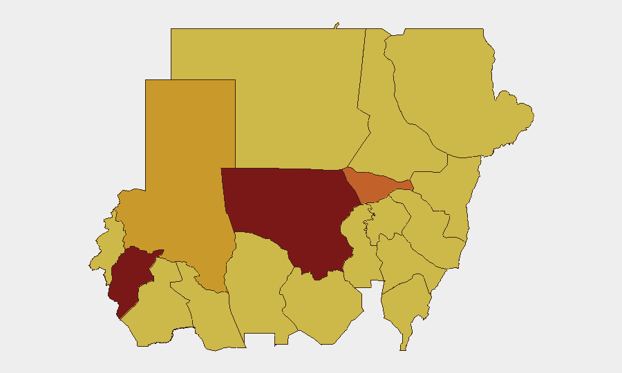
North Kordofan State (risk 100) and Central Darfur State (84.8) dominate the ranking, both epicenters of active RSF–SAF contestation and imminent offensive operations. Al Khartum (75.9) reflects capital-city instability and administrative fragmentation. The remaining high-risk tier (Blue Nile, River Nile, Aj Jazira, Red Sea, Al Qadarif, Kassala, Sennar, South Darfur—all 70+) indicates that warfare and lawlessness are now distributed across Sudan's breadth rather than localized, creating few truly safe corridors for personnel or supply chains.
How GeoBit Would Assist
Security teams should deploy Battle Mapping and Force Structure tracking to monitor SAF and RSF repositioning in real-time, coupled with GIS & Spatial Analysis for alternative routing around active conflict zones. AOI Monitoring with Early Warning on El Obeid, border regions, and secondary towns provides 24/7 alerting on offensive launches, force movements, and tribal violence spillover. OSINT fusion (Telegram, social media, radio SIGINT) captures frontline signals and civilian displacement flows ahead of formal reporting.
7-Day Outlook
An RSF offensive against El Obeid is likely imminent (within 7–10 days based on deployment patterns and diplomatic urgency). SAF counteroffensive operations in Darfur and Kordofan will proceed concurrently, creating multi-front kinetic activity and civilian displacement. Peripheral tribal and criminal violence will continue as state capacity remains absent; Red Sea and West Kordofan areas warrant sustained monitoring for secondary-order security failure.
Highest-Risk Areas — Ranked
| # | State / Region | Risk |
|---|---|---|
| 1 | North Kordofan State | 100 |
| 2 | Central Darfur State | 84.8 |
| 3 | Al Khartum | 75.9 |
| 4 | North Darfur State | 72 |
| 5 | Blue Nile | 70 |
| 6 | River Nile State | 70 |
| 7 | Aj Jazira | 70 |
| 8 | Red Sea State | 70 |
| 9 | Al Qadarif State | 70 |
| 10 | Kassala State | 70 |
| 11 | Sennar State | 70 |
| 12 | South Darfur State | 70 |
Sources
Previous Daily Briefs
A new Sudan brief is written every day — each with its own risk map and downloadable CSV. Here's the last week; use the calendar to go further back.
📅 Browse every day by calendar →
Highlighted days have a brief. Tap a day for that day's map & analysis, or “csv” for that day's dataset ($5).