Situation Summary
Suriname remains a low-to-moderate threat environment with no acute security incidents confirmed in the past 24–48 hours. Open-source monitoring and dedicated security feeds report absence of civil unrest, armed conflict, major crime spikes, or infrastructure disruption across the country. The composite national threat score of 15 reflects underlying vulnerabilities in interior mining zones and cross-border maritime areas, but these do not currently manifest as active crises affecting corporate operations or personnel in coastal districts.
Key Developments
- No verified acute security incidents in the past 24–48 hours across Suriname's ten administrative districts; routine governance, economic, and public-health activities (including chikungunya vector-control spraying in Paramaribo) dominate reporting for 20–21 July 2026.
- Political tensions between parliament and executive remain below escalation threshold; statements and friction documented around 14–19 July have not produced protests, institutional breakdown, or unrest as of 21 July.
- Public-health spraying operations ongoing in Paramaribo (Kwatta, Koewarasan) as routine dengue/chikungunya control measure; no security or civil-order disruption reported.
- Judicial and administrative developments (court cases, solar-financing initiatives, district official swearing-ins) on 20–21 July are routine governance; no linkage to security incidents.
Historical context (outside current 48-hour window but relevant to operational posture): The 14–15 July arrest of 14 armed Chinese nationals in Sarakreek (Brokopondo interior) and seizure of weapons remain the most significant recent incident; suspects were transferred to Paramaribo for prosecution. This underscores persistent illicit activity in remote mining and interior zones, but does not represent an ongoing active threat in coastal or urban areas as of 21 July.
Highest-Risk Areas
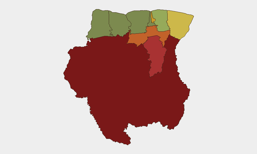
Sipaliwini (risk 92), Brokopondo (78), and Para (74) drive the national risk profile. These interior and south-central districts are characterized by limited state presence, artisanal and illegal mining activity, cross-border trafficking, and sparse infrastructure—creating environments conducive to weapons smuggling, narcotics transit, and unregulated armed groups. Paramaribo (71) carries elevated risk despite being the capital, reflecting urban crime, gang activity in peripheral neighborhoods, and governance vulnerabilities. Coastal districts (Commewijne, Wanica, Saramacca, Coronie, Nickerie) register significantly lower risk (8–42), making them substantially safer for corporate operations and personnel. Maritime boundaries with Guyana remain a secondary concern due to disputed maritime claims and occasional interdiction operations, but no active militarization is reported.
How GeoBit Would Assist
Corporate security teams operating in Suriname would deploy Intel Sweep and global event feeds for continuous incident monitoring, paired with OSINT fusion (X/Twitter, Telegram, local news aggregation) and multi-language search to surface early warnings in interior districts and cross-border zones before escalation. Area-of-interest (AOI) monitoring with persistent alerting on Sipaliwini, Brokopondo, and maritime boundaries would provide automated early warning of weapons trafficking, illegal mining incidents, or civil unrest. Conflict mapping, network/actor analysis, and maritime tracking capabilities enable teams to map supply routes, identify armed groups, and track illicit vessel movements in real time—critical for duty-of-care due diligence in high-risk interior zones.
7-Day Outlook
No acute deterioration is anticipated over the next seven days. Political tensions are expected to remain contained, and routine governance and economic activity will dominate. Interior mining zones and cross-border maritime areas will continue to pose latent risks requiring passive monitoring but do not signal imminent operational disruption for coastal or urban-based personnel.
Highest-Risk Areas — Ranked
| # | State / Region | Risk |
|---|---|---|
| 1 | Sipaliwini | 92 |
| 2 | Brokopondo | 78 |
| 3 | Para | 74 |
| 4 | Paramaribo | 71 |
| 5 | Marowijne | 68 |
| 6 | Commewijne | 42 |
| 7 | Wanica | 38 |
| 8 | Saramacca | 29 |
| 9 | Coronie | 12 |
| 10 | Nickerie | 8 |
Sources
Previous Daily Briefs
A new Suriname brief is written every day — each with its own risk map and downloadable CSV. Here's the last week; use the calendar to go further back.
📅 Browse every day by calendar →
Highlighted days have a brief. Tap a day for that day's map & analysis, or “csv” for that day's dataset ($5).
Atlas — our AI intelligence desk — emails them this snapshot personally. Nothing else, no list.