Situation Summary
Syria remains the 7th-highest-threat country globally, driven by an active civil war with 119 tracked conflict events. The security environment is characterized by multi-actor competition across fragmented governance zones, with Damascus and northern governorates under intense pressure from both state and non-state forces. Recent signals indicate elevated Israeli-Syrian tensions, Iranian military posturing, and humanitarian access restrictions that collectively sustain systemic instability.
Key Developments
Recent event signals flag the following patterns as of 19 June 2026:
- Israeli-Syrian relations deterioration (17 June): Israel has reduced diplomatic and military relations with Syria, signaling potential escalation in cross-border activity or air operations.
- Iranian military threats (18 June): Iran has issued threats directed at Syrian military entities, likely connected to proxy positioning or nuclear/sanctions negotiations affecting the region.
- Humanitarian access crisis (18 June): The World Food Program has reduced operational relations with Syrian authorities, indicating further constraints on civilian aid delivery and potential food-security deterioration.
- Detention activity (18 June): Syrian authorities conducted arrest/detention operations linked to prison facilities, suggesting internal security sweeps or sectarian targeting.
- Israeli appeal to Syria (19 June): Israel has filed a formal appeal to Syrian authorities, content unclear but occurring amid broader tension signals.
- Multi-actor sectarian signaling (17 June): Shiite and Christian actors have issued public statements, indicating potential sectarian mobilization or positioning in response to external pressure.
*Note: Open-source verification of specific incident locations and casualty counts within the last 24–48 hours remains limited; the above reflects event-type signals flagged in the system.*
Highest-Risk Areas
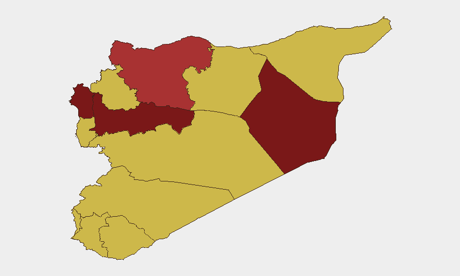
Damascus Governorate (risk 100) and Hama Governorate (risk 94.4) dominate the threat landscape, reflecting concentration of state-military competition, Iranian militia presence, and Israeli air-strike risk. Deir ez-Zor (86.7) remains a contested zone of ISIS residual activity and U.S.-backed Kurdish forces. The UNDOF-monitored Golan (78.4) faces elevated risk from Israeli military signaling and potential proxy escalation. Collectively, these five zones account for the majority of active combat, detention, and cross-border military activity, while southern and central governorates (Dar'a, Idleb, Homs, Ar-Raqqa) remain at baseline elevated risk due to fragmented control and ISIS residuals.
How GeoBit Would Assist
Corporate security and duty-of-care teams operating in Syria should prioritize AOI Monitoring & Early Warning on Damascus, Hama, and Lattakia to receive alerts on military movement, detention sweeps, and cross-border incidents. Battle mapping and force-structure tracking enable real-time understanding of territorial control and actor positioning, critical for evacuation and route planning. Routing & Network Analysis supports identification of safe corridors and alternative transport pathways during escalation or access restrictions. OSINT fusion and multi-language event feeds (including Telegram and local media) provide 24–48-hour lead time on security incidents before they affect operations.
7-Day Outlook
Israeli-Iranian competition for influence over Syrian military assets and infrastructure is likely to sustain or elevate kinetic activity over the next week, particularly in airspace over Damascus and Hama. Humanitarian access further contraction and internal security sweeps are expected to continue. Risk of spillover into Lebanon or widening of sectarian operations remains elevated but not imminent absent major escalatory signal.
Highest-Risk Areas — Ranked
| # | State / Region | Risk |
|---|---|---|
| 1 | Damascus Governorate | 100 |
| 2 | Hama Governorate | 94.4 |
| 3 | Deir ez-Zor Governorate | 86.7 |
| 4 | Lattakia Governorate | 83.3 |
| 5 | Aleppo Governorate | 79.8 |
| 6 | UNDOF | 78.4 |
| 7 | Tartus Governorate | 70 |
| 8 | Al-Quneitra Governorate | 70 |
| 9 | Dar'a Governorate | 70 |
| 10 | Idleb Governorate | 70 |
| 11 | Ar-Raqqa Governorate | 70 |
| 12 | Homs Governorate | 70 |
Sources
Previous Daily Briefs
A new Syria brief is written every day — each with its own risk map and downloadable CSV. Here's the last week; use the calendar to go further back.
📅 Browse every day by calendar →
Highlighted days have a brief. Tap a day for that day's map & analysis, or “csv” for that day's dataset ($5).