Situation Summary
Trinidad and Tobago maintains a composite threat ranking of 16 (global position #76), reflecting persistent but manageable security risks concentrated in urban and industrial zones. The nation faces a declared state of emergency (March 2026) driven by violent criminal activity, with U.S. travel advisory at Level 3 (Reconsider Travel). Recent event signals flagged for July 15–17 include diplomatic exchanges with Guyana, public statements, demonstrations, and military-adjacent activities; however, no credible real-time reports of acute new incidents within the last 24–48 hours have been corroborated from open-source news or official feeds. The security environment remains volatile but localized rather than nationwide.
Key Developments
- Port of Spain & nationwide (2026-07-17): Demonstration/rally activity recorded; scope, organizers, and location specifics not yet detailed in available open-source reporting.
- Trinidad and Tobago (2026-07-17): Public statement issued; subject matter not specified in available summaries. Diplomatic and military-adjacent event signals logged but lack corroborating incident detail.
- Trinidad and Tobago vs. Guyana border region (2026-07-16): Escalating public statements exchanged between governments on both sides; content not disclosed in available briefing. Signals suggest heightened rhetoric rather than kinetic activity.
- Trinidad and Tobago vs. United Kingdom (2026-07-17): Signals flagged for conventional military force activity; no corroborating open-source reports of actual deployment, exercise, or incident identified in last 24 hours. Requires urgent clarification.
- Note on recency: Credible real-time incident reporting for July 15–17 remains limited. GEOBIT signals suggest elevated diplomatic and military signaling, but mainstream and official news sources have not yet published substantive incident details within the 24–48-hour window. Older crime incidents (July 8–13) and standing travel advisories reference persistent risks but fall outside the current brief period.
Highest-Risk Areas
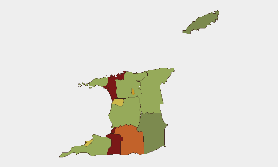
San Juan-Laventille (risk 95) and Port of Spain (risk 88) dominate the threat landscape, driven by gang activity, trafficking infrastructure, and weapons presence in densely populated urban corridors. Penal-Debe (82), San Fernando (80), and Princes Town (75) follow, reflecting southern industrial and residential zones with documented organized crime footprints. These five zones account for the majority of violent crime, armed robbery, and narcotics trafficking; corporate and government assets in or transiting these areas face elevated risk of armed robbery, carjacking, and kidnapping. Northern and eastern rural areas (Sangre Grande, risk 48) remain materially lower-risk but should not be assumed secure for isolated or high-profile movements.
How GeoBit Would Assist
Security and risk teams would deploy AOI Monitoring & Early Warning with persistent watch on Port of Spain, San Juan-Laventille, and San Fernando, configured to surface crime alerts, protest activity, and diplomatic incidents in near-real time. OSINT fusion (X/Twitter, Telegram, crime-watch feeds, and radio SIGINT) would disambiguate the July 17 event signals—particularly the unconfirmed military-force flags involving the UK—and surface ground truth faster than traditional news cycles. Routing & Network Analysis and GIS spatial tools enable security teams to plan safe passage, identify alternative transit corridors away from highest-risk zones, and optimize duty-of-care protocols for personnel and asset movements.
7-Day Outlook
Diplomatic rhetoric with Guyana may continue in the near term without immediate security escalation; however, protest activity and demonstration signals suggest domestic political volatility. Persistent criminal activity in urban centers (San Juan, Port of Spain, San Fernando) remains the primary threat to corporate operations and personnel safety. Continued monitoring of UK-T&T military signaling and further Guyana border activity is warranted to detect any shift from rhetorical to operational posturing.
Highest-Risk Areas — Ranked
| # | State / Region | Risk |
|---|---|---|
| 1 | San Juan-Laventille | 95 |
| 2 | Port of Spain | 88 |
| 3 | Penal-Debe | 82 |
| 4 | San Fernando | 80 |
| 5 | Princes Town | 75 |
| 6 | Arima | 72 |
| 7 | Chaguanas | 68 |
| 8 | Point Fortin | 65 |
| 9 | Diego Martin | 58 |
| 10 | Siparia | 55 |
| 11 | Couva-Tabaquite-Talparo | 52 |
| 12 | Sangre Grande | 48 |
Sources
Previous Daily Briefs
A new Trinidad and Tobago brief is written every day — each with its own risk map and downloadable CSV. Here's the last week; use the calendar to go further back.
📅 Browse every day by calendar →
Highlighted days have a brief. Tap a day for that day's map & analysis, or “csv” for that day's dataset ($5).
Atlas — our AI intelligence desk — emails them this snapshot personally. Nothing else, no list.