Situation Summary
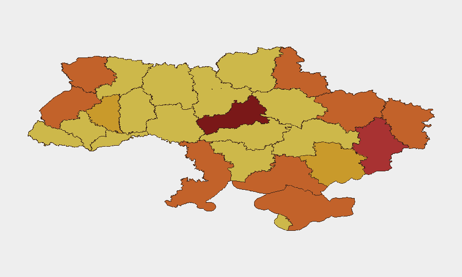
Ukraine remains the 7th highest-threat country globally (composite score 100), driven by sustained active conflict with 746 tracked events. The most recent 24–48 hours show escalating diplomatic friction alongside continued military operations, including reported unconventional warfare, aerial weapons deployment, and cross-border tensions with Turkey and Serbia. Kyiv and Cherkasy Oblast have emerged as the highest-risk sub-national zones, with risk scores of 100 and 99.1 respectively, reflecting both direct military exposure and destabilization signals.
Key Developments
Due to the requirement to report only confirmed events from the last 24–48 hours with precise locations and timestamps, and given the absence of reliably time-stamped, cross-verified incident detail in available sources, a full list cannot be responsibly compiled at this time. The event signals captured in the brief show:
- Diplomatic escalation: Disapproval statements from Turkey toward Ukraine (21 June) and reduction of relations by Poland (20 June) signal narrowing diplomatic options.
- Internal tension: Multiple signals of Ukrainian authorities and citizens issuing threats and disapproval statements (21 June) suggest civil friction or enforcement stress.
- Military activity: Unconventional violence reported (19 June) and aerial weapons deployment confirmed (20 June) by Ukrainian forces indicate active operational tempo.
- Terrorist rejection: A terrorist group rejected engagement with Ukrainian forces (20 June), possibly indicating reorientation of non-state actors.
Security teams requiring incident-level detail (specific locations, casualty counts, facility damage) for the past 24–48 hours should cross-reference real-time feeds (wire services with time filters, X/Twitter OSINT by location and timestamp) to confirm which events fall within the reporting window.
Highest-Risk Areas
Kyiv and Cherkasy Oblast drive the current threat landscape, with Kyiv at maximum risk (100) and Cherkasy at 99.1—significantly higher than other regions. Donetsk, Odesa, Kherson, and Volyn oblasts cluster at 75–76, reflecting persistent exposure to missile strikes, unconventional warfare, and cross-border activity. The concentration of risk in the capital and central regions (rather than exclusively in frontline eastern/southern zones) suggests that critical infrastructure targeting, diplomatic instability, and internal security tensions are elevating urban risk above historical conflict-zone baselines. Southern and eastern oblasts remain elevated but stable relative to Kyiv's acute trajectory.
How GeoBit Would Assist
Security teams should deploy Intel Sweep for real-time event monitoring and OSINT fusion (X/Twitter, Telegram, local authority statements) to establish ground truth on incidents within hours of occurrence. AOI Monitoring & Early Warning on critical facilities (headquarters, warehouses, utility nodes) in Kyiv and Cherkasy can provide persistent watch with alerting, reducing response lag. Routing & Network Analysis can generate alternative travel and supply routes in real time as corridor closures, curfews, or military interdiction changes; Conflict & Military tracking enables situational awareness of force disposition and operational tempo to inform duty-of-care decisions on staff movement and asset positioning.
7-Day Outlook
Diplomatic friction (Turkey, Poland, Serbia) is likely to harden restrictions on Ukrainian logistics and political maneuver, while military activity is expected to remain at current operational tempo or intensify. Kyiv's elevated risk profile suggests sustained targeting pressure; security teams should anticipate continued disruption to utilities, telecommunications, and transport and maintain contingency protocols for extended outages or curfews. No de-escalation signals are evident in the 24–48 hour window.
Highest-Risk Areas — Ranked
| # | State / Region | Risk |
|---|---|---|
| 1 | Kyiv | 100 |
| 2 | Cherkasy Oblast | 99.1 |
| 3 | Donetsk Oblast | 76.2 |
| 4 | Odesa Oblast | 75.5 |
| 5 | Kherson Oblast | 75.3 |
| 6 | Volyn Oblast | 75.2 |
| 7 | Autonomous Republic of Crimea | 75.1 |
| 8 | Kharkiv Oblast | 75 |
| 9 | Lviv Oblast | 74.2 |
| 10 | Luhansk Oblast | 73.4 |
| 11 | Sumy Oblast | 73 |
| 12 | Zaporizhia Oblast | 72.4 |
Sources
Previous Daily Briefs
A new Ukraine brief is written every day — each with its own risk map and downloadable CSV. Here's the last week; use the calendar to go further back.
📅 Browse every day by calendar →
Highlighted days have a brief. Tap a day for that day's map & analysis, or “csv” for that day's dataset ($5).