Situation Summary
Togo remains a low-threat environment globally (rank #94) with no confirmed discrete security incidents recorded in the past week. However, underlying vulnerabilities—unresolved intercommunal conflicts, cross-border criminality, and organized trafficking networks—persist across the northern and central regions, creating conditions for localized instability. Political friction continues in Lomé, though no active confrontations have been reported. The security picture reflects structural fragility rather than acute crisis.
Key Developments
- 14 October — Ghana–Togo border (Volta and Oti regions): Ghana's interior minister publicly called for strengthened community policing and cross-border cooperation, citing trafficking, smuggling, and organized crime affecting daily cross-border populations. This underscores ongoing transnational criminal flows in the border zone.
- 15 October — Savanes, Kara, and Centrale regions: A conflict-mapping assessment identified over 242 local conflicts across northern and central Togo, including land disputes, farmer–herder tensions, chiefly succession disputes, and intercommunal clashes. The report flagged unresolved tensions as vectors for violent-extremism recruitment and destabilization.
- 15 October — Lomé: The Supreme Court opened the judicial year amid continued rejection of political dialogue by opposition groups and demands for a transitional government. No new protests or confrontations were reported, but the political friction persists.
- 16 October — Lomé, Kpalimé, and Kara prisons: Authorities installed security infrastructure (walk-through detectors, parcel scanners, visitor storage) to prevent contraband weapons, knives, phones, and other prohibited items from entering prison facilities. This suggests ongoing efforts to address internal security management.
- 14 October — University of Datcha: Authorities warned of fraudulent admission offers targeting prospective students. No arrests or identified perpetrator network have been reported; the advisory indicates an active fraud risk but does not establish a broader criminal operation.
Highest-Risk Areas
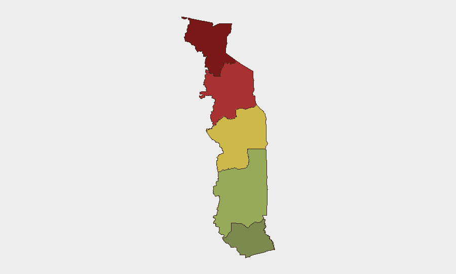
Savanes Region (risk 92) and Kara Region (risk 78) dominate the threat landscape, driven by the concentration of 242+ documented local conflicts, cross-border trafficking networks, and limited state capacity in remote areas. Centrale Region (risk 65) reflects secondary spillover from northern tensions and intercommunal disputes. Maritime Region (risk 28) and Plateaux Region (risk 45) remain comparatively stable. Northern risks are structural—rooted in land scarcity, herding pressures, weak dispute-resolution mechanisms, and proximity to cross-border criminal corridors—rather than event-driven.
How GeoBit Would Assist
Organizations with personnel or assets in Togo should leverage GeoBit's AOI Monitoring & Early Warning to track flashpoints in Savanes and Kara regions, triggering alerts if conflict indicators escalate. Multi-language OSINT and web research capabilities would provide continuous visibility on local disputes, trafficking activity, and political sentiment in Lomé. Routing & Network Analysis would identify safer cross-border transit corridors and alternative logistics paths to mitigate exposure to trafficking zones and criminal chokepoints.
7-Day Outlook
No imminent security escalation is anticipated in the near term; Togo's composite threat score remains low and incident reporting remains sparse. However, the persistence of 240+ unresolved intercommunal conflicts and ongoing political tension create a risk environment where localized flare-ups (chiefly disputes, herder clashes, or protest activity in Lomé) could occur with little advance warning. Duty-of-care teams should maintain baseline vigilance in Savanes and Kara, particularly around market days and seasonal herding transitions.
Highest-Risk Areas — Ranked
| # | State / Region | Risk |
|---|---|---|
| 1 | Savanes Region | 92 |
| 2 | Kara Region | 78 |
| 3 | Centrale Region | 65 |
| 4 | Plateaux Region | 45 |
| 5 | Maritime Region | 28 |
Sources
Previous Weekly Briefs
A new Togo brief is written every Monday, covering the week — each with its own risk map and downloadable CSV. Use the calendar to go further back.
- October 13, 2026
- October 6, 2026
- September 29, 2026
- September 22, 2026
- September 15, 2026
- September 8, 2026
- September 2, 2026
📅 Browse past briefs by calendar →
Highlighted days have a brief. Tap a day for that day's map & analysis, or “csv” for that day's dataset ($5).
Atlas — our AI intelligence desk — emails them this snapshot personally. Nothing else, no list.