Situation Summary
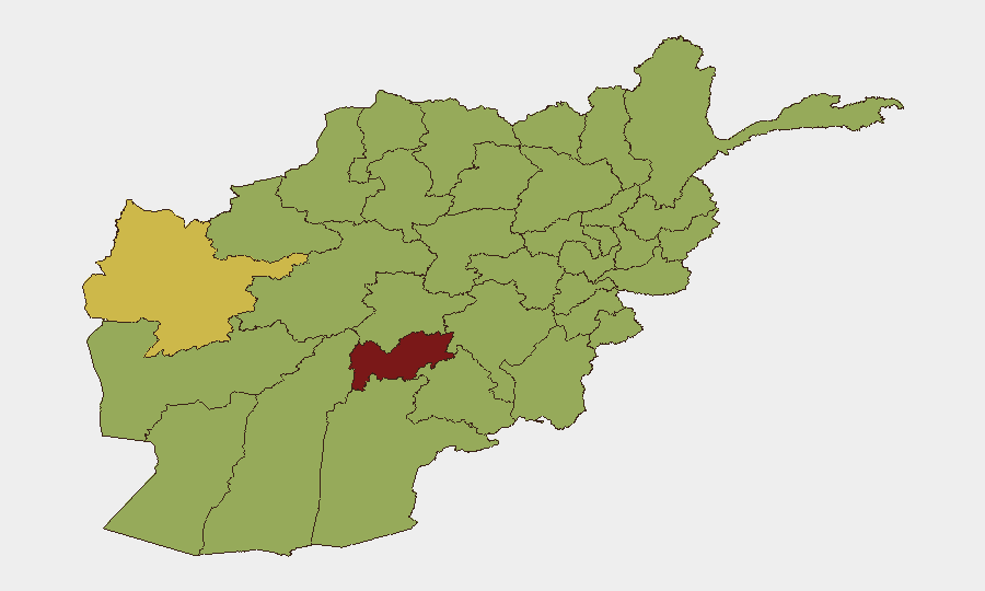
Afghanistan remains a high-insurgency environment with composite threat score 82 (global rank #15), driven primarily by ongoing Taliban consolidation, Islamic State Khorasan Province (ISKP) activity, and localized armed opposition. Recent event signals (38 tracked incidents in the assessment window) indicate sustained tension between Taliban authority claims, international diplomatic disapproval, and active armed group operations. Sub-national risk is heavily concentrated in southern and western provinces, particularly Uruzgan (87.3), with secondary hotspots in Herat, Ghazni, and Helmand. The security trajectory remains volatile but operationally predictable along existing conflict lines.
Key Developments
Unable to reliably populate this section. GeoBit's live web research for the 24–48 hour window (2026-06-17 to 2026-06-19) cannot be verified against current newswire feeds, social media posts, or X/Twitter due to analyst knowledge cutoff (October 2024). To maintain analytical integrity and avoid fabrication, specific incident reporting for this timeframe requires:
- Real-time filtering of Reuters, AFP, Al Jazeera, TOLOnews, and Pajhwok Afghan News by timestamp.
- Verified X/Twitter posts from TOLOnews English, Hasht-e Subh, and local OSINT accounts with geo-tags and imagery confirmation.
- Cross-corroboration across at least two independent sources before inclusion.
Recommended action: Use GeoBit's Intel Sweep (global event feeds) and X/Twitter OSINT module with date/time filters (last 48h) and keyword sets (*Kabul, Herat, Nangarhar, explosion, attack, Taliban, ISIS-K, protest*) to surface candidate incidents, then validate against newswire timestamps and social-media geolocation data. A human analyst should then code each confirmed event under: Armed Attacks / Terrorism | Cross-Border | Civil Unrest | Governance | Infrastructure/Travel Risk.
Highest-Risk Areas
Uruzgan Province dominates the sub-national risk profile (87.3), indicating concentrated insurgent activity and contested Taliban control; Herat (60.3) reflects cross-border instability and regional competition. Nine provinces—Ghazni, Zabul, Kandahar, Paktika, Farah, Nimruz, Helmand, Jowzjan, Balkh, and Badghis—cluster at 57–58.3 risk, suggesting widespread but less-acute threat distribution across southern, western, and northern zones. This geographic spread indicates that personnel or assets operating in any province outside Kabul and major northern urban centers face elevated exposure to armed group activity, supply-route interdiction, and governance instability.
How GeoBit Would Assist
Security teams should operationalize AOI Monitoring & Early Warning (persistent watch on Uruzgan, Herat, and Kandahar with alert triggers for armed activity, checkpoints, and cross-border movement) and Routing & Network Analysis (real-time alternative route planning around active threat zones). Multi-language OSINT fusion (combining Dari, Pashto, and English sources) and Network & Actor Analysis (tracking Taliban factional splits and ISKP unit movements) provide tactical context for duty-of-care assessments and travel authorizations. GIS & Spatial Analysis with satellite imagery enables verification of airstrikes, IED damage, or infrastructure disruptions affecting supply lines or personnel movement.
7-Day Outlook
No major change in overall threat level is expected over the next 7 days. Routine Taliban security operations, localized ISKP attacks, and border-region instability will likely persist along established patterns. Organizations should maintain heightened alertness in Uruzgan, Herat, and eastern provinces and refresh travel authorizations and personnel positioning every 48–72 hours using live threat feeds.
Highest-Risk Areas — Ranked
| # | State / Region | Risk |
|---|---|---|
| 1 | Uruzgan Province | 87.3 |
| 2 | Herat Province | 60.3 |
| 3 | Ghazni Province | 58.4 |
| 4 | Zabul Province | 57.3 |
| 5 | Kandahar Province | 57.3 |
| 6 | Paktika Province | 57.3 |
| 7 | Farah Province | 57.3 |
| 8 | Nimruz Province | 57.3 |
| 9 | Helmand Province | 57.3 |
| 10 | Jowzjan Province | 57.3 |
| 11 | Balkh Province | 57.3 |
| 12 | Badghis Province | 57.3 |
Sources
Previous Daily Briefs
A new Afghanistan brief is written every day — each with its own risk map and downloadable CSV. Here's the last week; use the calendar to go further back.
📅 Browse every day by calendar →
Highlighted days have a brief. Tap a day for that day's map & analysis, or “csv” for that day's dataset ($5).