Situation Summary
Afghanistan remains a high-risk operating environment (global rank #34, composite threat score 68) driven primarily by ongoing insurgency and militant activity. Over the past 48 hours, small-arms combat involving police, militant actors, and cross-border exchanges with Pakistan has continued, alongside unconventional violence attributed to Taliban operations. The security picture remains fragmented by geography, with southern and eastern provinces substantially more volatile than northern regions.
Key Developments
- 2026-06-20 · Cross-border small-arms combat · Afghanistan–Pakistan border. Multiple small-arms exchanges reported between Afghan and Pakistani forces; public statements from both governments indicate heightened tension along the frontier.
- 2026-06-20 · Small-arms combat · Police engagement. Afghan National Police engaged in armed conflict; no confirmed casualty or location data in available reporting.
- 2026-06-19 · Unconventional violence · Taliban operations. Taliban-attributed attacks on Afghan military/government personnel reported; specific locations and casualty counts unconfirmed in available 24-hour data.
- 2026-06-20 · Public statement · Afghan Superior Court. Official statement issued in response to security or governance matters; exact content and implications require verification through direct source review.
- 2026-06-18 · Rejection statement · Afghanistan. Government or institutional rejection of external demand or proposal; context unclear from available signals.
- 2026-06-19 · Threat statement · Afghan actor. Unspecified Afghan actor issued public threat; target and nature of threat require clarification through primary-source verification.
Note: Detailed 24–48-hour incident location and casualty data are not available in current open-source reporting. Confirmation of exact provinces, unit designations, and attack scope requires real-time OSINT collection.
Highest-Risk Areas
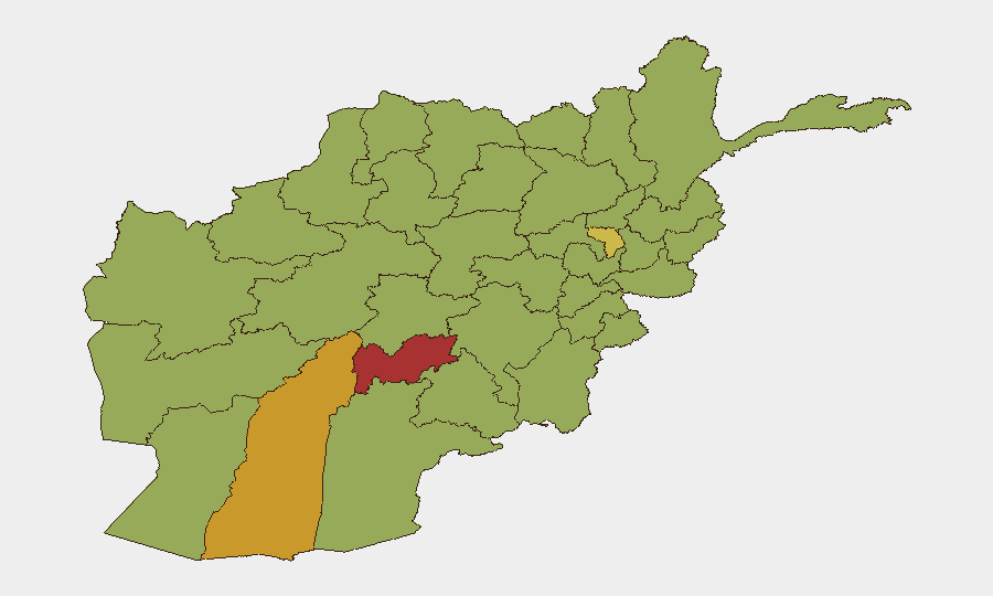
Uruzgan, Helmand, and Kapisa provinces present the most acute threat profiles (risk scores 77.8, 72.9, and 70.8 respectively), reflecting sustained Taliban and militant operational capacity in the south and east. Uruzgan's ranking is particularly elevated, indicating concentrated insurgent presence and anti-government activity. Kabul Province (48.5) and secondary provinces along the eastern and southern borders (Paktia, Zabul, Kandahar, Ghazni, Paktika, Farah) carry moderate-to-elevated risk, primarily from asymmetric attack and kidnapping threats. The cross-border tension with Pakistan adds an additional vector of unpredictability to provinces adjacent to the frontier.
How GeoBit Would Assist
Security teams with personnel or assets in Afghanistan should deploy Intel Sweep and multi-language X/Telegram OSINT collection to track militia announcements, attack claims, and cross-border escalation signals in real time. Area-of-interest (AOI) monitoring with alerting on Uruzgan, Helmand, and Kapisa provinces provides persistent early warning of combat, checkpoints, or blockades affecting travel and supply routes. Battle mapping and force-structure analysis integrated with alternative-route planning and network analysis enable duty-of-care teams to model movement corridors, identify high-risk transit zones, and develop contingency evacuation or repositioning plans if cross-border or Taliban activity escalates.
7-Day Outlook
Cross-border Pakistan–Afghanistan friction is likely to remain elevated through late June, potentially constraining movement in eastern provinces and creating checkpoint delays. Taliban and militant activity is expected to continue at baseline or slightly above in Uruzgan and Helmand; no major sustained offensive is signaled in available reporting, but localized ambush and IED risk will persist. Continued monitoring of UN Security Council statements and diplomatic channels is warranted, as regional pressure on Afghanistan's government may influence force posture or curfew announcements affecting operations.
Highest-Risk Areas — Ranked
| # | State / Region | Risk |
|---|---|---|
| 1 | Uruzgan Province | 77.8 |
| 2 | Helmand Province | 72.9 |
| 3 | Kapisa Province | 70.8 |
| 4 | Paktia Province | 49.9 |
| 5 | Kabul Province | 48.5 |
| 6 | Zabul Province | 47.8 |
| 7 | Kandahar Province | 47.8 |
| 8 | Ghazni Province | 47.8 |
| 9 | Paktika Province | 47.8 |
| 10 | Farah Province | 47.8 |
| 11 | Nimruz Province | 47.8 |
| 12 | Jowzjan Province | 47.8 |
Sources
Previous Daily Briefs
A new Afghanistan brief is written every day — each with its own risk map and downloadable CSV. Here's the last week; use the calendar to go further back.
📅 Browse every day by calendar →
Highlighted days have a brief. Tap a day for that day's map & analysis, or “csv” for that day's dataset ($5).