Situation Summary
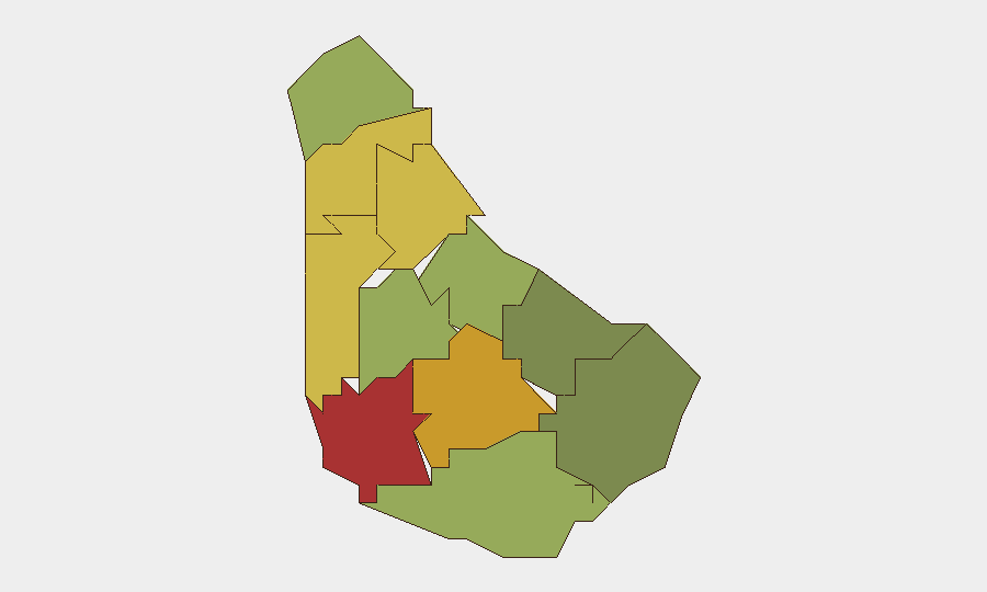
Barbados remains a low-threat environment globally (composite rank #182) with no discrete security incidents recorded in the current monitoring window. The primary risk driver in the last 24–48 hours is meteorological rather than security-related: the Barbados Meteorological Services issued small-craft and high-surf warnings on 13–14 August as a tropical wave approached, bringing high winds, excess rainfall, and thunderstorms. Sub-national risk concentration is highest in Saint Michael (78), Saint George (72), and Saint James (68), reflecting urban density and historical incident clustering in Bridgetown and western parishes.
Key Developments
- Island-wide marine/weather advisory — 2026-08-13 to 2026-08-14: Barbados Meteorological Services issued small-craft and high-surf warnings with anticipated high winds, excess rainfall, and thunderstorms as a tropical wave system approached. This affects marine operations, coastal logistics, and outdoor activities but is not a security incident.
- No corroborated security or crime incidents recorded — 2026-08-13 to 2026-08-14: Web research and event feeds yielded no verified criminal activity, civil unrest, infrastructure disruption, or political-security developments during this window.
- Persistent sub-national concentration in urban parishes: Saint Michael and Saint George continue to carry the highest composite risk scores, consistent with historical patterns of incident clustering in and near Bridgetown.
Highest-Risk Areas
Saint Michael (78), Saint George (72), and Saint James (68) account for the highest risk concentration. These are urban and semi-urban parishes encompassing Bridgetown's commercial and residential core, where population density, economic activity, and historical crime patterns drive composite risk scores. Saint Andrew (65) and Saint Peter (62) represent secondary risk zones. Christ Church, Saint John, Saint Philip, and Saint Lucy carry significantly lower scores, reflecting lower population density and incident frequency; these areas present proportionally lower exposure for corporate operations and personnel.
How GeoBit Would Assist
AOI Monitoring & Early Warning with persistent watch on Saint Michael, Saint George, and Saint James would flag emerging criminal activity, civil unrest, or infrastructure disruption within hours of occurrence. Intel Sweep and multi-source OSINT fusion—including local news, social media sentiment, and radio SIGINT—enables early detection of brewing incidents before they escalate. Routing & Network Analysis supports duty-of-care teams in planning alternative travel routes and safe corridors for personnel and supply chains, particularly during weather events or localized incidents; combined with GIS & Spatial Analysis, this enables rapid risk-aware journey re-planning around high-risk parishes.
7-Day Outlook
The tropical weather system is expected to clear within 48–72 hours, after which meteorological risk will normalize. No intelligence indicators suggest emerging security incidents, civil unrest, or political instability over the next week. The security posture is expected to remain stable; sub-national risk concentration in urban parishes will persist but remain consistent with baseline patterns.
Highest-Risk Areas — Ranked
| # | State / Region | Risk |
|---|---|---|
| 1 | Saint Michael | 78 |
| 2 | Saint George | 72 |
| 3 | Saint James | 68 |
| 4 | Saint Andrew | 65 |
| 5 | Saint Peter | 62 |
| 6 | Saint Joseph | 58 |
| 7 | Saint Thomas | 52 |
| 8 | Saint Lucy | 48 |
| 9 | Christ Church | 42 |
| 10 | Saint John | 35 |
| 11 | Saint Philip | 28 |
Sources
Previous Daily Briefs
A new Barbados brief is written every day — each with its own risk map and downloadable CSV. Here's the last week; use the calendar to go further back.
- August 12, 2026
- August 10, 2026
- August 8, 2026
- August 6, 2026
- August 5, 2026
- August 4, 2026
- August 3, 2026
📅 Browse every day by calendar →
Highlighted days have a brief. Tap a day for that day's map & analysis, or “csv” for that day's dataset ($5).
Atlas — our AI intelligence desk — emails them this snapshot personally. Nothing else, no list.