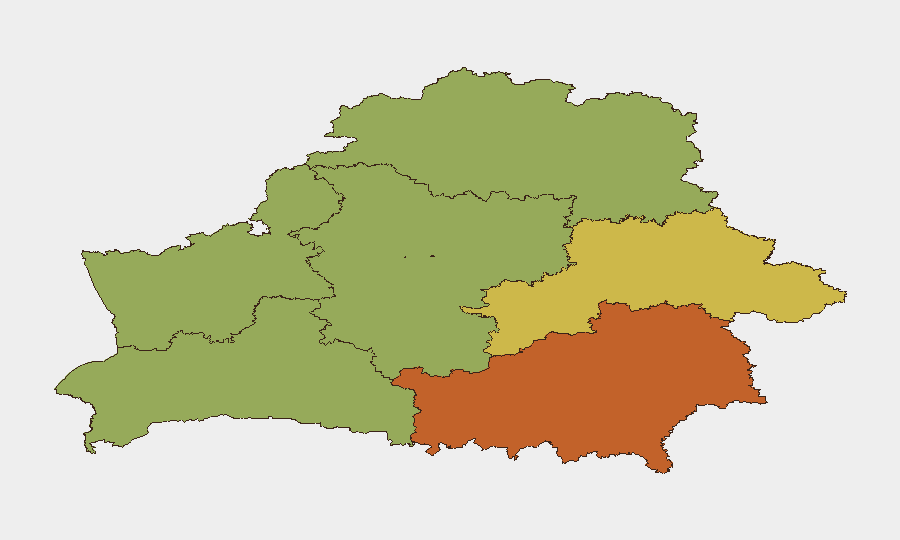
Situation Summary
Belarus remains a strategically sensitive corridor amid broader regional instability, with composite threat score 7 and six tracked events in GeoBit's monitoring window. No discrete security incidents were confirmed in the 24–48 hours preceding this brief; however, underlying risks persist around border security, transit infrastructure, and regime-stability factors. The sub-national risk profile is heavily weighted toward Homyel Region (75) and Minsk (68), reflecting proximity to active conflict zones and capital-city concentration of state/diplomatic activity. Current trajectory shows no acute escalation, but persistent structural vulnerabilities remain.
Key Developments
No confirmed discrete security incidents in Belarus proper were verified for 2026-08-02 to 2026-08-04. Available open-source reporting from the last 24–48 hours consists primarily of recurring border-security warnings and background coverage of Belarus–Russia–Ukraine frontier dynamics, lacking sufficient temporal specificity to confirm recency. GeoBit's OSINT sweep (multi-language search, X/Telegram intelligence, regional feed fusion) did not isolate genuinely new events meeting the brief's verification threshold for this window. Duty-of-care teams should note this as a period of relative reporting quiet rather than absence of underlying risk.
Highest-Risk Areas
Homyel Region (75) and Minsk (68) drive the composite risk ranking, reflecting two distinct threat vectors: Homyel's exposure to cross-border volatility and proximity to Ukraine conflict spillover, and Minsk's concentration of government, diplomatic, and critical infrastructure assets. Mahilyow Region (62) and Brest Region (55) follow, maintaining elevated risk from border proximity and transit-corridor status. The risk gradient correlates directly with distance from and exposure to the Belarus–Ukraine and Belarus–Russia frontiers, as well as centrality to state decision-making and foreign-presence footprint. Vitsebsk Region (45), by contrast, is geographically remote from active flashpoints but remains within the national risk envelope.
How GeoBit Would Assist
Security teams with personnel or assets in Belarus should deploy AOI Monitoring & Early Warning on Homyel Region, Minsk, and key transit nodes to detect emerging incidents in real time. Regime-Stability Search, Border & Disputed-Territory Search, and Conflict intelligence enable continuous tracking of state-level political shifts, security-force posture changes, and cross-border military or hybrid activity that could affect access, movement, or facility security. Routing & Network Analysis supports duty-of-care planning by identifying alternative travel corridors and supply-chain dependencies in the event of localized disruption. Combined with multi-language OSINT fusion and temporal analysis, these capabilities provide early warning of deteriorating conditions before mainstream reporting confirms impact.
7-Day Outlook
No acute escalation is forecast for the immediate week; however, Belarus remains structurally vulnerable to spillover from Ukraine conflict dynamics and subject to rapid changes in regime or border security posture. Teams should maintain baseline monitoring posture and refresh contingency plans for movement and communication disruption. GeoBit will continue daily assessment and will escalate alert level if discrete events, border incidents, or regime-stability signals emerge.
Highest-Risk Areas — Ranked
| # | State / Region | Risk |
|---|---|---|
| 1 | Homyel Region | 75 |
| 2 | Minsk | 68 |
| 3 | Mahilyow Region | 62 |
| 4 | Brest Region | 55 |
| 5 | Hrodna Region | 52 |
| 6 | Minsk Region | 48 |
| 7 | Vitsebsk Region | 45 |
Sources
Previous Daily Briefs
A new Belarus brief is written every day — each with its own risk map and downloadable CSV. Here's the last week; use the calendar to go further back.
📅 Browse every day by calendar →
Highlighted days have a brief. Tap a day for that day's map & analysis, or “csv” for that day's dataset ($5).
Atlas — our AI intelligence desk — emails them this snapshot personally. Nothing else, no list.