Situation Summary
Belize remains at moderate global risk (#95 globally, composite score 17) with crime and gang activity as the primary driver. Recent 24–48 hour reporting shows continued violent crime in urban and rural settings, alongside emerging labor-government friction and highway robbery targeting commercial transport. No major incidents, infrastructure failures, or organized unrest are documented for 20–21 August 2026, but baseline homicide and armed robbery patterns persist across Belize City and interior districts.
Key Developments
- Ranguana Caye stabbing – murder charge formalized (20–21 Aug 2026, incident 12 Aug). Belize City fisherman Mauri Gomez was formally arraigned and remanded on a murder charge for fatally stabbing Jose Arteaga aboard a sailboat near Ranguana Caye. Victim's family disputes police narrative, signaling potential confidence issues with law enforcement and continued tension within fishing communities.
- George Price Highway armed robbery (reported 20–21 Aug 2026). A truck driver was shot during an armed robbery on the George Price Highway, the primary commercial corridor linking Belize City to the interior. Details remain limited, but the incident signals heightened risk for overland transport and logistics operations.
- NTUCB labor demonstration organizing (statement 20 Aug 2026). The National Trade Union Congress of Belize formally called for removal of BTL (Belize Telemedia Limited) chairman and board members on 20 August 2026, following Cabinet rejection of a telecom acquisition. Union leaders plan demonstrations in Belize City and Belmopan with multi-district participation; crowd gatherings and traffic disruption around government and BTL facilities are likely.
- Belize City–Orange Walk highway fatality (18 Aug 2026). Fatal road traffic accident at Mile 27 (Biscayne Village) on the Belize City–Orange Walk highway forced police closure for over two hours. While a single incident, it reflects ongoing transport-corridor vulnerability.
- Pomona Village police-civilian shooting fallout (coverage through 19–21 Aug, incident 6 Aug). Cattle farmer Richard Cal remains remanded on three counts of aggravated assault with a firearm following a disputed 6 August shooting confrontation with plain-clothes officers near Pomona Village, Stann Creek District. Continued media and social coverage indicates unresolved community-police tensions in rural areas.
- German travel advisory reissued (updated 20 Aug 2026). Updated security guidance emphasizes persistent violent crime risk (armed robbery, homicide, sexual assault) in Belize City and tourist areas including San Pedro Town, Caye Caulker, and Placencia, indicating sustained baseline threat recognition by international sources.
Highest-Risk Areas
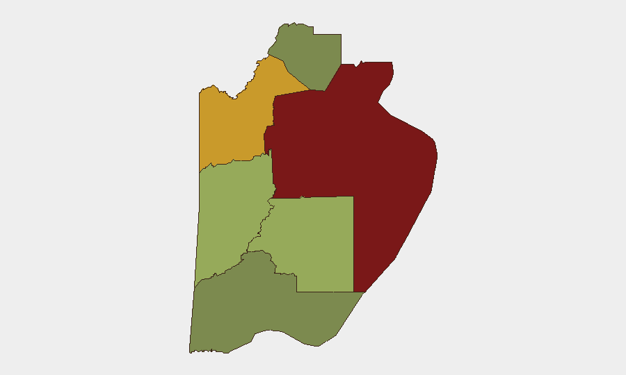
Belize District (risk 95) dominates the threat landscape, driven primarily by urban gang violence, homicides, and armed robbery in and around Belize City. Orange Walk District (risk 72) and Cayo District (risk 58) follow, reflecting spillover gang activity and property crime in secondary urban centers and interior highways. Stann Creek District (risk 48) and Toledo District (risk 35) carry moderate risk, with localized gang presence and rural crime. Corozal District (risk 22) remains the lowest-risk region. Commercial operations and personnel should maintain heightened awareness in the top three districts and along the George Price Highway corridor.
How GeoBit Would Assist
AOI Monitoring & Early Warning would provide persistent watch over Belize City, key transport corridors (George Price Highway, Belize City–Orange Walk), and government/BTL facilities to detect emerging protest activity and crime hotspots. OSINT Fusion across local news, social media, and open sources would corroborate crime reports and labor organizing activity in near-real time. Routing & Network Analysis would enable alternative-route planning for personnel and cargo movements to avoid identified robbery and gang-activity zones.
7-Day Outlook
Union demonstrations are anticipated in the coming days (possibly 24 August 2026 onward), likely triggering crowd gatherings and traffic disruption in Belize City and Belmopan. Baseline violent crime—homicide, armed robbery, and gang-related incidents—will persist, particularly in Belize District and along major highways; no de-escalation indicators are present. Commercial transport and urban movement should assume heightened risk for the next 7 days.
Highest-Risk Areas — Ranked
| # | State / Region | Risk |
|---|---|---|
| 1 | Belize District | 95 |
| 2 | Orange Walk District | 72 |
| 3 | Cayo District | 58 |
| 4 | Stann Creek District | 48 |
| 5 | Toledo District | 35 |
| 6 | Corozal District | 22 |
Sources
Previous Daily Briefs
A new Belize brief is written every day — each with its own risk map and downloadable CSV. Here's the last week; use the calendar to go further back.
- August 19, 2026
- August 17, 2026
- August 15, 2026
- August 13, 2026
- August 11, 2026
- August 9, 2026
- August 8, 2026
📅 Browse every day by calendar →
Highlighted days have a brief. Tap a day for that day's map & analysis, or “csv” for that day's dataset ($5).
Atlas — our AI intelligence desk — emails them this snapshot personally. Nothing else, no list.