Situation Summary
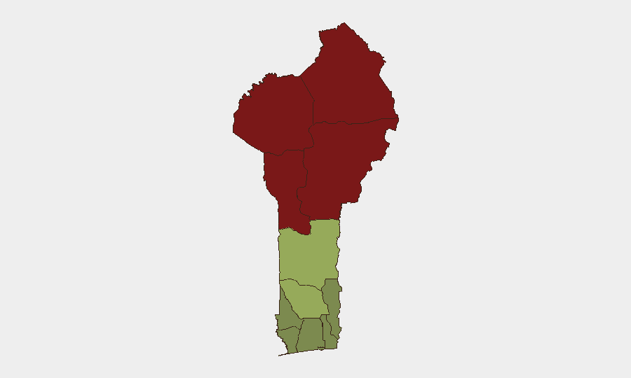
Benin remains a lower-priority global security risk (rank #59, composite score 21) but faces acute and worsening pressure in its northern departments, primarily driven by jihadist infiltration from Burkina Faso and coordinated cross-border instability in the Lake Chad Basin. Northern Benin is increasingly a transit and displacement zone rather than a primary conflict theater, but the convergence of Nigerian military operations, refugee inflows, and armed-group activity is raising operational complexity for organizations with northern assets. No major incidents were recorded in central or southern Benin in the last 24–48 hours.
Key Developments
- Nigeria–Benin–Niger Border, 3 July 2026 – Nigeria's defence minister announced creation of a new tri-border military sector specifically to counter jihadist infiltration along the Nigeria–Benin–Niger frontier. This signals a formal escalation in joint border operations and an expected increase in military presence and activity along Benin's northern boundary over coming weeks, with potential for increased checkpoint activity, temporary movement restrictions, and cross-border operations.
- Northern Benin (Alibori/Atakora Departments), Late June–3 July 2026 – UNHCR reported a deteriorating Lake Chad Basin security environment driving new displacement from northern Nigeria into Benin. Nigerian nationals fleeing armed-group attacks are arriving in northern Benin, compounding existing humanitarian strain and creating localized security dynamics in already high-risk departments.
- Public Statement Signal, 7 July 2026 – GeoBit event signals recorded a public statement flagged as "PHYSICIAN vs BENIN CITY," indicating some form of institutional or individual statement on Benin City–related security or governance. Limited detail is available; further monitoring is recommended to determine materiality.
Highest-Risk Areas
Alibori, Atakora, Donga, and Borgou departments (risk scores 92, 88, 85, 83 respectively) dominate Benin's threat profile. All four border Nigeria and Niger and sit within or adjacent to known jihadist infiltration corridors from Burkina Faso. Refugee and armed-group transit, cross-border military operations, and sporadic armed-group activity are the primary drivers. Southern and central departments (Atlantique, Littoral, Ouémé) remain substantially lower-risk and are suitable for normal business operations. Zou and Collines departments present moderate risk and warrant standard due-diligence protocols.
How GeoBit Would Assist
Organizations with personnel or assets in northern Benin should deploy AOI Monitoring & Early Warning on Alibori and Atakora to capture refugee movements, military deployments, and armed-group signals in near-real time. Network & Actor Analysis can map armed groups and military units active in the tri-border zone, while Intel Sweep (multi-language OSINT, X/Telegram, entity extraction) will provide early visibility into operational announcements, displacement reports, and security-force positioning. Routing & Network Analysis can identify alternative supply and personnel routes to mitigate exposure to high-risk northern corridors.
7-Day Outlook
Northern Benin will likely see increased military activity and checkpoint density as the Nigeria–Benin–Niger tri-border sector becomes operational. Refugee and armed-group transit is expected to persist. Central and southern regions will remain stable. Organizations should update contingency protocols for northern operations and confirm personnel communication and evacuation chains.
Highest-Risk Areas — Ranked
| # | State / Region | Risk |
|---|---|---|
| 1 | Alibori Department | 92 |
| 2 | Atakora Department | 88 |
| 3 | Donga Department | 85 |
| 4 | Borgou Department | 83 |
| 5 | Zou Department | 45 |
| 6 | Collines Department | 42 |
| 7 | Plateau Department | 38 |
| 8 | Kouffo Department | 35 |
| 9 | Mono Department | 32 |
| 10 | Atlantique Department | 28 |
| 11 | Littoral | 25 |
| 12 | Ouémé Department | 22 |
Sources
Previous Daily Briefs
A new Benin brief is written every day — each with its own risk map and downloadable CSV. Here's the last week; use the calendar to go further back.
📅 Browse every day by calendar →
Highlighted days have a brief. Tap a day for that day's map & analysis, or “csv” for that day's dataset ($5).
Atlas — our AI intelligence desk — emails them this snapshot personally. Nothing else, no list.