Situation Summary
Bhutan remains a stable, low-threat operating environment with no confirmed security incidents, civil unrest, or infrastructure disruptions reported in the last 24–48 hours. A small cluster of administrative and diplomatic signals flagged on 19–20 July (public statements from government, business disapproval notices, and diplomatic exchanges) remain unverified and lack independent corroboration across multiple sources. Overall threat trajectory is neutral; no escalation indicators are present.
Key Developments
- No independently confirmed incidents in the last 24–48 hours meeting operational reporting threshold. All current signals lack multi-source corroboration.
- Several unverified administrative/diplomatic signals (19–20 July) remain under monitoring but do not yet constitute confirmed operational events. These include public statements involving electoral bodies, government ministries, and business-sector commentary.
- No transport, energy, or communications infrastructure disruptions reported or forecast for the coming week.
- No travel-risk escalations identified for Bhutan's main corridors or urban centers (Thimphu, Paro, Phobjikha Valley).
Highest-Risk Areas
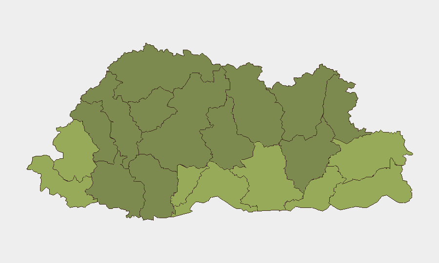
Southern and eastern border districts drive Bhutan's sub-national risk profile. Samtse, Sarpang, and Haa districts (composite scores 58, 55, and 52 respectively) form a high-risk tier, likely reflecting cross-border sensitivities with India and historical settlement tensions. Eastern districts—Pemagatshel, Samdrup Jongkhar, and Trashigang (scores 50, 48, and 40)—face elevated baseline risk from terrain, border proximity, and infrastructure gaps. By contrast, Thimphu and central highland districts remain substantially lower-risk. For corporate operations, personnel deployed to Samtse, Sarpang, or Haa should maintain heightened situational awareness; southern supply chains warrant contingency routing through central corridors.
How GeoBit Would Assist
Security teams with assets or personnel in Bhutan should deploy AOI (Area-of-Interest) Monitoring & Early Warning focused on Samtse, Sarpang, and Haa districts to catch emerging civil, border, or infrastructure signals before they escalate. Intel Sweep and multi-language OSINT fusion (including local news, social media, and radio SIGINT) will corroborate or discount unverified administrative signals and detect ground-level sentiment shifts. Alternative Route/Network Analysis (Routing & Network Mapping) enables rapid rerouting of personnel or cargo away from affected districts if conditions change. Combined, these tools reduce response lag and duty-of-care exposure.
7-Day Outlook
No material change in threat posture is forecast for the next seven days. Current unverified signals show no coherence or escalatory pattern and remain at administrative/diplomatic level. Continued low-threat assessment is warranted unless independent corroboration of the 19–20 July signals emerges or new multi-source incident reports surface. Standard corporate security protocols and regional travel advisories remain appropriate.
GeoBit Daily Security Brief | Bhutan | 2026-07-21
*Composite Threat Score: 4 | Global Rank: #null | Events Tracked: 6*
Highest-Risk Areas — Ranked
| # | State / Region | Risk |
|---|---|---|
| 1 | Samtse District | 58 |
| 2 | Sarpang District | 55 |
| 3 | Haa District | 52 |
| 4 | Pemagatshel District | 50 |
| 5 | Samdrup Jongkhar District | 48 |
| 6 | Tsirang District | 45 |
| 7 | Zhemgang District | 42 |
| 8 | Trashigang District | 40 |
| 9 | Mongar District | 38 |
| 10 | Gasa District | 35 |
| 11 | Lhuntse District | 32 |
| 12 | Wangdue Phodrang District | 30 |
Previous Daily Briefs
A new Bhutan brief is written every day — each with its own risk map and downloadable CSV. Here's the last week; use the calendar to go further back.
📅 Browse every day by calendar →
Highlighted days have a brief. Tap a day for that day's map & analysis, or “csv” for that day's dataset ($5).
Atlas — our AI intelligence desk — emails them this snapshot personally. Nothing else, no list.