Situation Summary
Bolivia is experiencing acute civil unrest driven by prolonged economic blockades and fuel shortages that have paralyzed supply chains for approximately 50 days. On June 20, President Rodrigo Paz declared a nationwide state of emergency to authorize expanded military deployment for clearing roadblocks, signaling both escalation in government response and continued pressure from protest movements affiliated with former president Evo Morales. The crisis has created acute humanitarian risks—food, fuel, and medicine shortages are widespread—and threatens to destabilize key urban centers and transit corridors. Current threat trajectory is upward, with military engagement now imminent across multiple departments.
Key Developments
- La Paz — June 20, 2026: President Rodrigo Paz declared a nationwide state of emergency to enable military deployment against blockades and restore road access; order followed announcement of a negotiated deal with the Bolivian Workers' Confederation (COB) intended to de-escalate tensions.
- Cochabamba — June 20, 2026: Major road links remained under active blockade by rural groups affiliated with Evo Morales despite the presidential emergency declaration and COB agreement, indicating fragmented protest leadership and continued supply-chain disruption.
- La Paz / Cochabamba / El Alto — June 19–20, 2026: Food, fuel, and medicine delivery chains remain severely disrupted after 50 days of blockade activity; shortages are now acute in major urban centers and pose humanitarian risk.
- Nationwide — June 20, 2026: Military deployment to clear roadblocks and restore order is now authorized under emergency powers; direct confrontation between security forces and blockade operators is probable in coming days.
Highest-Risk Areas
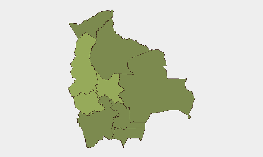
Cochabamba (risk score 53.7) and Oruro (48.8) present the highest composite threat, with Cochabamba facing ongoing blockades by rural groups and both departments serving as critical nodes in Bolivia's fuel and food supply chains. La Paz (42.3), though slightly lower-ranked, remains a political epicenter and the seat of government response; emergency declarations and military operations will be coordinated from the capital, making it a focal point for both escalation and negotiation. The remaining departments (Potosí, Tarija, Pando, Beni, Chuquisaca, Santa Cruz) carry moderate to lower risk but may experience secondary economic impact and sporadic protest activity. Risk is concentrated in western and central Bolivia along historical protest and indigenous-mobilization corridors.
How GeoBit Would Assist
Security teams should deploy AOI Monitoring & Early Warning on Cochabamba and La Paz transit corridors to track blockade locations, movement, and checkpoints in near-real-time; Network & Actor Analysis to map protest leadership, COB affiliates, and Morales-linked organizational nodes; and Routing & Network Analysis to identify alternative supply and personnel routes for corporate operations. Satellite & Imagery analysis and GIS & Spatial Analysis capabilities enable tracking of military deployment patterns and identification of safe transit windows. Conflict & Military force-structure tracking provides visibility on military unit positioning and readiness.
7-Day Outlook
Military clearing operations are expected to intensify over the next 3–5 days as emergency powers are deployed, likely producing confrontations and possible civilian casualties that will further polarize urban and rural constituencies. Negotiations between government and COB may produce temporary localized relief, but blockades by non-COB rural groups (particularly in Cochabamba) are likely to persist. Supply-chain recovery will be measured in weeks rather than days; organizations with critical dependencies on fuel, food, or medicine should prioritize alternative sourcing and personnel safety protocols now.
Highest-Risk Areas — Ranked
| # | State / Region | Risk |
|---|---|---|
| 1 | Cochabamba | 53.7 |
| 2 | Oruro | 48.8 |
| 3 | La Paz | 42.3 |
| 4 | Potosí | 24.5 |
| 5 | Tarija | 24.5 |
| 6 | Pando | 23.7 |
| 7 | Beni | 23.7 |
| 8 | Chuquisaca | 23.7 |
| 9 | Santa Cruz | 23.7 |
Sources
Previous Daily Briefs
A new Bolivia brief is written every day — each with its own risk map and downloadable CSV. Here's the last week; use the calendar to go further back.
📅 Browse every day by calendar →
Highlighted days have a brief. Tap a day for that day's map & analysis, or “csv” for that day's dataset ($5).